Trail Horseback riding Saint-Sauveur-de-Ginestoux - boucle saint sauveur 18 km - Photo

boucle saint sauveur 18 km

© OpenStreetMap contributors
Length
Length
18.3 km
Max alt
Max alt
1331 m
Uphill gradient
Uphill gradient
334 m
Km-Effort
Km-Effort  
23 km
Min alt
Min alt
1209 m
Downhill gradient
Downhill gradient
333 m
Boucle
Boucle
Yes
Creation date :
2020-01-27 12:07:48.087
Updated on :
2020-01-27 12:15:41.665

(0 Reviews)

Horseback riding
Horseback riding
2h50
Difficulty : Medium

Scan this QR Code to open this trail in the SityTrail application

FREE GPS app for hiking

Logo SityTrail SityTrail

IGN / Geographical institutes

Download SityTrail from the App Store Download SityTrail from Google Play

Logo SityTrail SityTrail World

The world is yours!

Download SityTrail from the App Store Download SityTrail from Google Play Download SityTrail on Huawei AppGallery

About

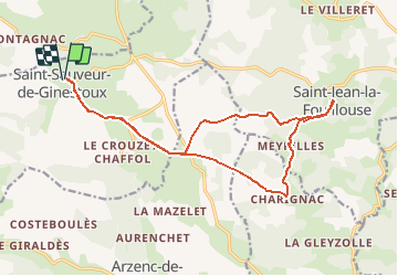
Trail Horseback riding of 18.3 km to be discovered at Occitania, Lozère, Saint-Sauveur-de-Ginestoux. This trail is proposed by Lozère Cheval.

Elevation profile

Positioning

Country:
France
Region :
Occitania
Department/Province :
Lozère
Municipality :
Saint-Sauveur-de-Ginestoux
Location:
Unknown
Start:(Dec)
Start:(UTM)
548073 ; 4950365 (31T) N.

Trails nearby

Trail Mountain bike Arzenc-de-Randon - 06 GTMC Le Giraldès-Le Pont de Monvert - Photo
Mountain bike
nicolas54230

Mountain bike

Easy
(1)
Arzenc-de-Randon, Occitania, Lozère, France
90 km | 113 km-effort
15min
No
Trail Mountain bike Arzenc-de-Randon - Fait GTMC 2022  E2 3,3 b - Photo
Mountain bike
jl77130

Mountain bike

Difficult
Arzenc-de-Randon, Occitania, Lozère, France
54 km | 69 km-effort
6h 14min
No
Trail Mountain bike Arzenc-de-Randon - GTMC de Claire - 6 - Photo
Mountain bike
tracegps

Mountain bike

Very difficult
Arzenc-de-Randon, Occitania, Lozère, France
58 km | 74 km-effort
4h 30min
No
Trail Horseback riding Arzenc-de-Randon - Circuit Petites Prairies en Margeride MAJ 2020  - Photo
Horseback riding
Lozère Cheval

Horseback riding

Medium
Arzenc-de-Randon, Occitania, Lozère, France
58 km | 74 km-effort
2h 45min
Yes
Trail Horseback riding Saint-Sauveur-de-Ginestoux - 11042391-boucle lac de charpal - Photo
Horseback riding
Lozère Cheval

Horseback riding

Difficult
Saint-Sauveur-de-Ginestoux, Occitania, Lozère, France
32 km | 41 km-effort
5h 8min
Yes
Trail Horseback riding Saint-Sauveur-de-Ginestoux - Etoile Sentier des Croix - Photo
Horseback riding
Lozère Cheval

Horseback riding

Medium
Saint-Sauveur-de-Ginestoux, Occitania, Lozère, France
16.6 km | 22 km-effort
2h 40min
Yes
Trail On foot Monts-de-Randon - COL DE LA CROIX DE BOR /MASSOUSE - Photo
On foot
FLORENSAC

On foot

Medium
Monts-de-Randon, Occitania, Lozère, France
13.4 km | 16.3 km-effort
Unknown
Yes
Trail Mountain bike Arzenc-de-Randon - Boucle Le Giraldès - Photo
Mountain bike
phcol

Mountain bike

Medium
Arzenc-de-Randon, Occitania, Lozère, France
40 km | 51 km-effort
4h 10min
Yes
Trail Other activity Monts-de-Randon - lozere col des 3 soeurs - Photo
Other activity
mijojo

Other activity

Very easy
Monts-de-Randon, Occitania, Lozère, France
19.3 km | 24 km-effort
Unknown
Yes


Close
My subscriptions