Trail Walking Malaucène - MALAUCENE  - Photo
© OpenStreetMap contributors
Length
Length
22 km
Max alt
Max alt
699 m
Uphill gradient
Uphill gradient
754 m
Km-Effort
Km-Effort  
32 km
Min alt
Min alt
299 m
Downhill gradient
Downhill gradient
754 m
Boucle
Boucle
Yes
Creation date :
2020-01-30 08:34:48.541
Updated on :
2020-02-03 11:20:29.158

(0 Reviews)

Walking
Walking
7h26
Difficulty : Difficult

Scan this QR Code to open this trail in the SityTrail application

FREE GPS app for hiking

Logo SityTrail SityTrail

IGN / Geographical institutes

Download SityTrail from the App Store Download SityTrail from Google Play

Logo SityTrail SityTrail World

The world is yours!

Download SityTrail from the App Store Download SityTrail from Google Play Download SityTrail on Huawei AppGallery

About

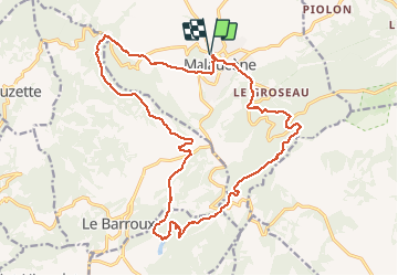
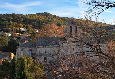
Trail Walking of 22 km to be discovered at Provence-Alpes-Côte d'Azur, Vaucluse, Malaucène. This trail is proposed by FLORENSAC.

Description

traversee de malaucene par les ruelles
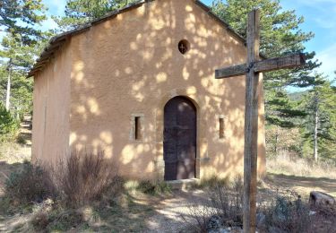
passer devant les anciennes papeterie  suivre le sentier des croix jusqu'a la chapelle de PIAUD
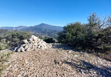
Une jolie descente vers la combe de l aze
et le sentier des crêtes (à ne pas faire par grand vent =
le lac du PATY puis retour vers Malaucene en passant par Les AMBROSIS
ET LE COL DE LA CHAINE

Elevation profile

Photos

Points of interest

Point of interest Malaucène - sentier des cretes - Photo
FLORENSAC
MALAUCÈNE 

Positioning

Country:
France
Region :
Provence-Alpes-Côte d'Azur
Department/Province :
Vaucluse
Municipality :
Malaucène
Location:
Unknown
Start:(UTM)
670209 ; 4893535 (31T) N.

Trails nearby

Trail Walking Entrechaux - Entrechaux en Vaucluse - Photo
Walking
tracegps

Walking

Medium
(1)
Entrechaux, Provence-Alpes-Côte d'Azur, Vaucluse, France
9.5 km | 13.7 km-effort
2h 40min
Yes
Trail Walking Saint-Hippolyte-le-Graveyron - Le graveron petit circuit  - Photo
Walking
Vero7684

Walking

Easy
(1)
Saint-Hippolyte-le-Graveyron, Provence-Alpes-Côte d'Azur, Vaucluse, France
5.7 km | 8.8 km-effort
2h 5min
Yes
Trail Walking Le Barroux - Lac du Barroux - Photo
Walking
alainbarrot

Walking

Very easy
(2)
Le Barroux, Provence-Alpes-Côte d'Azur, Vaucluse, France
5.8 km | 8 km-effort
1h 42min
Yes
Trail Running Le Barroux - Sortie Barroux - Photo
Running
ssi6159

Running

Very easy
(1)
Le Barroux, Provence-Alpes-Côte d'Azur, Vaucluse, France
12.9 km | 20 km-effort
1h 47min
Yes
Trail Walking Malaucène - Campagne de Malaucène - Photo
Walking
tracegps

Walking

Easy
(2)
Malaucène, Provence-Alpes-Côte d'Azur, Vaucluse, France
6.6 km | 8.1 km-effort
1h 30min
Yes
Trail Walking Malaucène - Autour de Malaucène  - Photo
Walking
GUIDE
nadinebondoux

Walking

Difficult
Malaucène, Provence-Alpes-Côte d'Azur, Vaucluse, France
18.3 km | 27 km-effort
5h 53min
Yes
Trail Walking Malaucène - Malaucène  - Photo
Walking
GUIDE
Roger Philippe Wallez

Walking

Very difficult
Malaucène, Provence-Alpes-Côte d'Azur, Vaucluse, France
18.6 km | 27 km-effort
6h 32min
Yes
Trail Walking Caromb - Les 3 Termes 449 le Groseau - Photo
Walking
supercolas

Walking

Medium
Caromb, Provence-Alpes-Côte d'Azur, Vaucluse, France
11.1 km | 16.9 km-effort
2h 56min
Yes
Trail Walking La Roque-Alric - Les 4 sommets de la Roque Alric - Photo
Walking
supercolas

Walking

Medium
La Roque-Alric, Provence-Alpes-Côte d'Azur, Vaucluse, France
10.9 km | 18 km-effort
3h 32min
Yes


Close
My subscriptions