Trail Walking Saint-Pardoux-la-Rivière - St-Pardoux-la-Rivière Dorie 13km - Photo

St-Pardoux-la-Rivière Dorie 13km

 YV24
YV24

User

© OpenStreetMap contributors
Length
Length
12.4 km
Max alt
Max alt
318 m
Uphill gradient
Uphill gradient
255 m
Km-Effort
Km-Effort  
15.8 km
Min alt
Min alt
140 m
Downhill gradient
Downhill gradient
255 m
Boucle
Boucle
Yes
Creation date :
2014-12-10 00:00:00.0
Updated on :
2014-12-10 00:00:00.0

(1 Reviews)

Walking
Walking
3h26
Difficulty : Easy

Scan this QR Code to open this trail in the SityTrail application

FREE GPS app for hiking

Logo SityTrail SityTrail

IGN / Geographical institutes

Download SityTrail from the App Store Download SityTrail from Google Play

Logo SityTrail SityTrail World

The world is yours!

Download SityTrail from the App Store Download SityTrail from Google Play Download SityTrail on Huawei AppGallery

About

Trail Walking of 12.4 km to be discovered at New Aquitaine, Dordogne, Saint-Pardoux-la-Rivière. This trail is proposed by YV24.

Description

Selon PDIPR boucle de la Dorie.
Attention, tracé balisé pour le sens anti horaire seulement. Pas mal (trop) de bitume. Chemin creux entre Chaumeille et Bon Ombre. Parcours  à éviter en période humide et de pluie récente.

Elevation profile

Positioning

Country:
France
Region :
New Aquitaine
Department/Province :
Dordogne
Municipality :
Saint-Pardoux-la-Rivière
Location:
Unknown
Start:(UTM)
323789 ; 5040151 (31T) N.

Comments

Please log in to post a review or rate the element


Trails nearby

Trail Walking Milhac-de-Nontron - Milhac de Nontron Chadeuil 12km - Photo
Walking
YV24

Walking

Easy
(1)
Milhac-de-Nontron, New Aquitaine, Dordogne, France
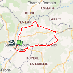
11.8 km | 14.8 km-effort
3h 11min
Yes
Trail Walking Milhac-de-Nontron - Boucle de Milhac de Nontron à Croze - Photo
Walking
CC.RIDER

Walking

Difficult
Milhac-de-Nontron, New Aquitaine, Dordogne, France
14.2 km | 17.8 km-effort
4h 2min
Yes
Trail Walking Saint-Front-la-Rivière - tour de la vierge - Photo
Walking
Patricew

Walking

Easy
Saint-Front-la-Rivière, New Aquitaine, Dordogne, France
8.9 km | 11.2 km-effort
2h 10min
No
Trail Walking Saint-Front-la-Rivière - boucle la renaudie - Photo
Walking
fab0202

Walking

Easy
Saint-Front-la-Rivière, New Aquitaine, Dordogne, France
10.1 km | 12.4 km-effort
2h 18min
Yes
Trail Walking Champs-Romain - Champs-Romain Tacot 12km - Photo
Walking
YV24

Walking

Difficult
Champs-Romain, New Aquitaine, Dordogne, France
11.6 km | 14.3 km-effort
3h 6min
Yes
Trail Walking Champs-Romain - saut du chalard par Larret - Photo
Walking
Zygomat

Walking

Difficult
Champs-Romain, New Aquitaine, Dordogne, France
9.9 km | 13.5 km-effort
2h 56min
Yes
Trail Hybrid bike Saint-Pardoux-la-Rivière - Balade à vélo voie verte st pardaux la rivière - Photo
Hybrid bike
jumbo0861

Hybrid bike

Very easy
Saint-Pardoux-la-Rivière, New Aquitaine, Dordogne, France
34 km | 40 km-effort
3h 3min
No
Trail Walking Champs-Romain - Périgord vert saut du chalard - Photo
Walking
attelageplaisir

Walking

Very easy
Champs-Romain, New Aquitaine, Dordogne, France
3.8 km | 5.2 km-effort
1h 39min
Yes
Trail Walking Saint-Pardoux-la-Rivière - Boucle- st  pardoux - Photo
Walking
Melifera

Walking

Very difficult
Saint-Pardoux-la-Rivière, New Aquitaine, Dordogne, France
19.4 km | 25 km-effort
5h 34min
No


Close
My subscriptions