Trail Walking Gap - 220221 Tour Golf col Bayard  - Photo

220221 Tour Golf col Bayard

 Rangabe
Rangabe

User

© OpenStreetMap contributors
Length
Length
6.2 km
Max alt
Max alt
1301 m
Uphill gradient
Uphill gradient
152 m
Km-Effort
Km-Effort  
8.2 km
Min alt
Min alt
1242 m
Downhill gradient
Downhill gradient
152 m
Boucle
Boucle
Yes
Creation date :
2020-02-21 13:29:51.129
Updated on :
2020-02-21 17:04:15.428

(0 Reviews)

Walking
Walking
1h34
Difficulty : Very easy

Scan this QR Code to open this trail in the SityTrail application

FREE GPS app for hiking

Logo SityTrail SityTrail

IGN / Geographical institutes

Download SityTrail from the App Store Download SityTrail from Google Play

Logo SityTrail SityTrail World

The world is yours!

Download SityTrail from the App Store Download SityTrail from Google Play Download SityTrail on Huawei AppGallery

About

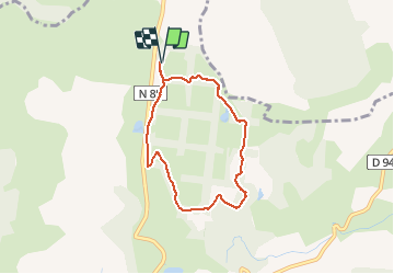
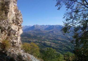
Trail Walking of 6.2 km to be discovered at Provence-Alpes-Côte d'Azur, Hautes-Alpes, Gap. This trail is proposed by Rangabe.

Description

Tour du golfe du col Bayard en suivant le parcours sportif avec départ du parking du Golf

Elevation profile

Positioning

Country:
France
Region :
Provence-Alpes-Côte d'Azur
Department/Province :
Hautes-Alpes
Municipality :
Gap
Location:
Gap
Start:(UTM)
268628 ; 4944914 (32T) N.

Trails nearby

Trail Walking Gap - Brèche et croix de Charance - Photo
Walking
GUIDE
R@ph

Walking

Easy
(1)
Gap, Provence-Alpes-Côte d'Azur, Hautes-Alpes, France
8.6 km | 18.5 km-effort
2h 13min
No
Trail Walking Gap - R17   la Breche de Charance - Photo
Walking
GUIDE+

Walking

Medium
Gap, Provence-Alpes-Côte d'Azur, Hautes-Alpes, France
6.3 km | 14.1 km-effort
2h 48min
Yes
Trail Walking Gap - R16   Le parc de Charance - Photo
Walking
GUIDE+

Walking

Very easy
Gap, Provence-Alpes-Côte d'Azur, Hautes-Alpes, France
3.6 km | 5.2 km-effort
1h 8min
Yes
Trail Walking Laye - Sentier de la Cuque prolongé - Photo
Walking
frederique.marti@laposte.net

Walking

Very easy
(1)
Laye, Provence-Alpes-Côte d'Azur, Hautes-Alpes, France
11.8 km | 19.7 km-effort
2h 24min
Yes
Trail Walking Gap - Brèche de Charance - Col de Gleize - Photo
Walking
GUIDE
R@ph

Walking

Difficult
Gap, Provence-Alpes-Côte d'Azur, Hautes-Alpes, France
8 km | 18.1 km-effort
2h 29min
No
Trail Walking Saint-Laurent-du-Cros - St Laurent du Cros 27/01/24 - Photo
Walking
GUIDE
R@ph

Walking

Easy
Saint-Laurent-du-Cros, Provence-Alpes-Côte d'Azur, Hautes-Alpes, France
6.9 km | 9.2 km-effort
2h 4min
Yes
Trail Walking Gap - 3-pics-gleize_randonnee-40057005 - Photo
Walking
PapouBertrand

Walking

Difficult
Gap, Provence-Alpes-Côte d'Azur, Hautes-Alpes, France
6.9 km | 13.7 km-effort
3h 6min
Yes
Trail Walking Gap - Pic de Charance - Photo
Walking
Marco05

Walking

Medium
Gap, Provence-Alpes-Côte d'Azur, Hautes-Alpes, France
8.9 km | 19 km-effort
4h 18min
Yes
Trail Walking Gap - Pic de Gleize - Photo
Walking
Marco05

Walking

Medium
Gap, Provence-Alpes-Côte d'Azur, Hautes-Alpes, France
4.8 km | 10.6 km-effort
2h 25min
Yes


Close
My subscriptions