Trail Walking Viroflay - La grande traversée des forêts des Hauts de Seine - Photo

La grande traversée des forêts des Hauts de Seine

© OpenStreetMap contributors
Length
Length
18.7 km
Max alt
Max alt
185 m
Uphill gradient
Uphill gradient
343 m
Km-Effort
Km-Effort  
24 km
Min alt
Min alt
44 m
Downhill gradient
Downhill gradient
415 m
Boucle
Boucle
No
Creation date :
2020-02-25 08:11:51.384
Updated on :
2020-03-02 11:39:04.164

(0 Reviews)

Walking
Walking
6h30
Difficulty : Easy

Scan this QR Code to open this trail in the SityTrail application

FREE GPS app for hiking

Logo SityTrail SityTrail

IGN / Geographical institutes

Download SityTrail from the App Store Download SityTrail from Google Play

Logo SityTrail SityTrail World

The world is yours!

Download SityTrail from the App Store Download SityTrail from Google Play Download SityTrail on Huawei AppGallery

About

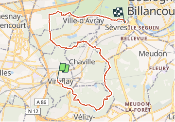
Trail Walking of 18.7 km to be discovered at Ile-de-France, Yvelines, Viroflay. This trail is proposed by c.chehere.

Description

De la station T "Viroflay Rive gauche" à la station T2 "musée de Sèvres"
Itinéraire décrit dans l'autre sens dans le topoguide FFRP "Villes, parcs et forêts des  hauts de Seine .... à pied

Elevation profile

Photos

Positioning

Country:
France
Region :
Ile-de-France
Department/Province :
Yvelines
Municipality :
Viroflay
Location:
Unknown
Start:(UTM)
439158 ; 5405646 (31U) N.

Trails nearby

Trail Walking Chaville - Le Sentier des 7 étangs - Photo
Walking
tracegps

Walking

Difficult
(5)
Chaville, Ile-de-France, Hauts-de-Seine, France
23 km | 31 km-effort
5h 0min
Yes
Trail Walking Viroflay - Les 3 Forêts; Meudon, Fausses Reposes et Versailles - Photo
Walking
tracegps

Walking

Difficult
(2)
Viroflay, Ile-de-France, Yvelines, France
25 km | 32 km-effort
5h 19min
Yes
Trail Walking Chaville - Sentier des deux Forêts - Meudon et Verrières - Photo
Walking
tracegps

Walking

Difficult
(2)
Chaville, Ile-de-France, Hauts-de-Seine, France
23 km | 29 km-effort
5h 0min
Yes
Trail Walking Buc - Le Tour de Satory - Photo
Walking
tracegps

Walking

Difficult
(2)
Buc, Ile-de-France, Yvelines, France
23 km | 28 km-effort
4h 49min
Yes
Trail Walking Boulogne-Billancourt - Parc de St Cloud et forêt de Fausses Reposes - Photo
Walking
tracegps

Walking

Medium
(1)
Boulogne-Billancourt, Ile-de-France, Hauts-de-Seine, France
18.2 km | 23 km-effort
4h 30min
No
Trail Other activity Versailles - Parc de Versailles - Photo
Other activity
irokoitennis

Other activity

Very easy
(1)
Versailles, Ile-de-France, Yvelines, France
8.9 km | 9.7 km-effort
1h 49min
Yes
Trail Cycle Chaville - chaville - maison lafitte - Photo
Cycle
Letizia

Cycle

Medium
(1)
Chaville, Ile-de-France, Hauts-de-Seine, France
44 km | 50 km-effort
3h 27min
No
Trail Mountain bike Chaville - grand circuit VTT - Photo
Mountain bike
macleon

Mountain bike

Very easy
(1)
Chaville, Ile-de-France, Hauts-de-Seine, France
32 km | 40 km-effort
Unknown
Yes
Trail Walking Vélizy-Villacoublay - Les forêts de Meudon et Versailles  - Photo
Walking
c.chehere

Walking

Easy
Vélizy-Villacoublay, Ile-de-France, Yvelines, France
14.5 km | 17.2 km-effort
3h 50min
Yes


Close
My subscriptions