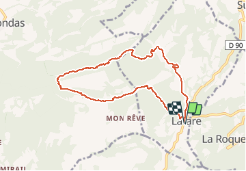
12.4 km | 22 km-effort
DENTELLES DE MONTMIRAIL PAR LAFARE
FLORENSAC
User
Length
9.2 km
Max alt
582 m
Uphill gradient
550 m
Km-Effort
16.5 km
Min alt
156 m
Downhill gradient
550 m
Boucle
Yes
Creation date :
2020-03-08 08:31:25.776
Updated on :
2020-03-16 12:05:04.309
5h38
Difficulty : Difficult
FREE GPS app for hiking
About
Trail Walking of 9.2 km to be discovered at Provence-Alpes-Côte d'Azur, Vaucluse, Lafare. This trail is proposed by FLORENSAC.
Description
Départ parking de LAFARE
suivre le tracé un peu sportif par endroit
deux dernières descentes bien abruptes
Positioning
Country:
France
Region :
Provence-Alpes-Côte d'Azur
Department/Province :
Vaucluse
Municipality :
Lafare
Location:
Unknown
Start:(Dec)
Start:(UTM)
664052 ; 4890106 (31T) N.
Comments
Trails nearby
Dentelles Montmirail - Gigondas
Walking
Very difficult
(3)
Gigondas,
Provence-Alpes-Côte d'Azur,
Vaucluse,
France
7h 0min
Yes
Le tour du Grand Montmirail - Lafare
Walking
Medium
(3)
Lafare,
Provence-Alpes-Côte d'Azur,
Vaucluse,
France
9.1 km | 13.9 km-effort
2h 30min
Yes
Le graveron petit circuit
Walking
Easy
(1)
Saint-Hippolyte-le-Graveyron,
Provence-Alpes-Côte d'Azur,
Vaucluse,
France
5.7 km | 8.8 km-effort
2h 5min
Yes
Une approche des Dentelles de Montmirail
Walking
Medium
(2)
Lafare,
Provence-Alpes-Côte d'Azur,
Vaucluse,
France
6.6 km | 11.4 km-effort
3h 0min
Yes
Gigondas Dentelles Sarasines Grande Montagne
Walking
Difficult
(1)
Gigondas,
Provence-Alpes-Côte d'Azur,
Vaucluse,
France
15.4 km | 26 km-effort
5h 57min
Yes
Grand Montmirail par 3 Yeux
Walking
Medium
(2)
Gigondas,
Provence-Alpes-Côte d'Azur,
Vaucluse,
France
13.3 km | 21 km-effort
4h 29min
Yes
dentelles de Montmirail
Walking
Very easy
(1)
Gigondas,
Provence-Alpes-Côte d'Azur,
Vaucluse,
France
15.7 km | 26 km-effort
8h 9min
Yes
Lac du Barroux
Walking
Very easy
(2)
Le Barroux,
Provence-Alpes-Côte d'Azur,
Vaucluse,
France
5.8 km | 8 km-effort
1h 42min
Yes
Sortie Barroux
Running
Very easy
(1)
Le Barroux,
Provence-Alpes-Côte d'Azur,
Vaucluse,
France
12.9 km | 20 km-effort
1h 47min
Yes