Trail Walking Champéry - Champéry - Col de Cou - Photo

Champéry - Col de Cou

© OpenStreetMap contributors
Length
Length
17.3 km
Max alt
Max alt
1935 m
Uphill gradient
Uphill gradient
422 m
Km-Effort
Km-Effort  
26 km
Min alt
Min alt
1034 m
Downhill gradient
Downhill gradient
1321 m
Boucle
Boucle
No
Creation date :
2014-12-11 00:00:00.0
Updated on :
2014-12-11 00:00:00.0

(0 Reviews)

Walking
Walking
5h56
Difficulty : Unknown

Scan this QR Code to open this trail in the SityTrail application

FREE GPS app for hiking

Logo SityTrail SityTrail

IGN / Geographical institutes

Download SityTrail from the App Store Download SityTrail from Google Play

Logo SityTrail SityTrail World

The world is yours!

Download SityTrail from the App Store Download SityTrail from Google Play Download SityTrail on Huawei AppGallery

About

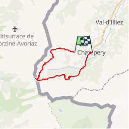
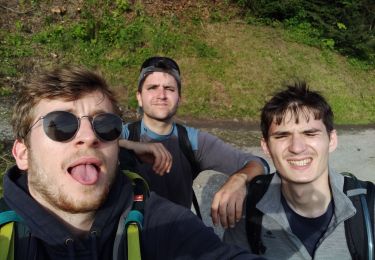
Trail Walking of 17.3 km to be discovered at Valais/Wallis, Monthey, Champéry. This trail is proposed by otchampery.

Description

Mit der Gondel von Champéry gelangen sie schnell und einfach zum Croix-de-Culet auf 2000 Meter über dem Meeresspiegel. Nehmen Sie sich die Zeit die Landschaft zu bewundern, den Glocken der Bergkühe zu lauschen.

Elevation profile

Points of interest

Point of interest Champéry - Départ - Photo
otchampery
CHAMPÉRY 
Point of interest Val-d'Illiez - Restaurant la Croix de Culet - Photo
otchampery
Point of interest Champéry -  - Photo
otchampery
CHAMPÉRY 
Point of interest Champéry - Gîte d'alpage Lapisa - Photo
otchampery
Point of interest Champéry - Hôtel-Restaurant Paradis - Photo
otchampery
Point of interest Champéry - Escalade - Photo
otchampery
CHAMPÉRY 
Point of interest Champéry - Gîte d'alpage La Pierre - Photo
otchampery
Point of interest Champéry -  - Photo
otchampery
CHAMPÉRY 
Point of interest Champéry - Arrivée - Photo
otchampery
CHAMPÉRY 
Point of interest Champéry - Office du Tourisme - Photo
otchampery
Point of interest Champéry - Champéry - Photo
otchampery
CHAMPÉRY 
Point of interest Champéry - Champéry TCP - Photo
otchampery
CHAMPÉRY 
Point of interest Champéry - Planachaux - Photo
otchampery
CHAMPÉRY 
Point of interest Champéry - Cantine les Dents-Blanches - Photo
otchampery
Point of interest Champéry - Cantine Barmaz - Photo
otchampery
CHAMPÉRY 

Positioning

Country:
Switzerland
Region :
Valais/Wallis
Department/Province :
Monthey
Municipality :
Champéry
Location:
Unknown
Start:(UTM)
333728 ; 5115765 (32T) N.

Trails nearby

Trail On foot Val-d'Illiez - Les Crosets-Sur Cou - Photo
On foot
PRO

On foot

Easy
Val-d'Illiez, Valais/Wallis, Monthey, Switzerland
3.6 km | 4.8 km-effort
1h 6min
No
Trail Walking Champéry - Champéry - Die Galérie Défago - Photo
Walking
otchampery

Walking

Very easy
(1)
Champéry, Valais/Wallis, Monthey, Switzerland
10.1 km | 15 km-effort
3h 38min
No
Trail Walking Val-d'Illiez - Lac de Soi - Photo
Walking
bozo1970

Walking

Very difficult
Val-d'Illiez, Valais/Wallis, Monthey, Switzerland
14.6 km | 30 km-effort
5h 19min
Yes
Trail Walking Montriond - J11GR5Nord - Photo
Walking
annehc

Walking

Very difficult
Montriond, Auvergne-Rhône-Alpes, Upper Savoy, France
15.3 km | 27 km-effort
4h 31min
No
Trail sport Val-d'Illiez - Vtt électrique aux Portes du soleil  - Photo
sport
Alfredy

sport

Very easy
Val-d'Illiez, Valais/Wallis, Monthey, Switzerland
52 km | 81 km-effort
Unknown
Yes
Trail Walking Val-d'Illiez - lac de soi par signal de soi - Photo
Walking
ajpbm

Walking

Difficult
Val-d'Illiez, Valais/Wallis, Monthey, Switzerland
10.4 km | 25 km-effort
4h 5min
Yes
Trail Walking Champéry - hike33 - Photo
Walking
GUIDE+

Walking

Very easy
Champéry, Valais/Wallis, Monthey, Switzerland
9.1 km | 15.9 km-effort
Unknown
No
Trail Walking Champéry - vs_hike808c - Photo
Walking
GUIDE+

Walking

Very easy
Champéry, Valais/Wallis, Monthey, Switzerland
102 km | 194 km-effort
36h 47min
Yes
Trail Walking Champéry - vs_hike808a - Photo
Walking
GUIDE+

Walking

Very easy
Champéry, Valais/Wallis, Monthey, Switzerland
41 km | 89 km-effort
14h 46min
Yes


Close
My subscriptions