Trail Other activity Ayent - VS - Audannes Wildhorn - Photo

VS - Audannes Wildhorn

© OpenStreetMap contributors
Length
Length
11.2 km
Max alt
Max alt
3217 m
Uphill gradient
Uphill gradient
1511 m
Km-Effort
Km-Effort  
29 km
Min alt
Min alt
1781 m
Downhill gradient
Downhill gradient
768 m
Boucle
Boucle
No
Creation date :
2014-12-11 00:00:00.0
Updated on :
2014-12-11 00:00:00.0

(0 Reviews)

Other activity
Other activity
--
Difficulty : Unknown

Scan this QR Code to open this trail in the SityTrail application

FREE GPS app for hiking

Logo SityTrail SityTrail

IGN / Geographical institutes

Download SityTrail from the App Store Download SityTrail from Google Play

Logo SityTrail SityTrail World

The world is yours!

Download SityTrail from the App Store Download SityTrail from Google Play Download SityTrail on Huawei AppGallery

About

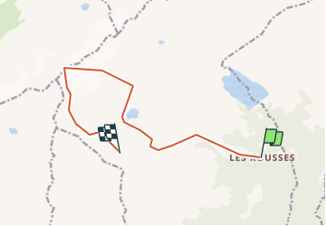
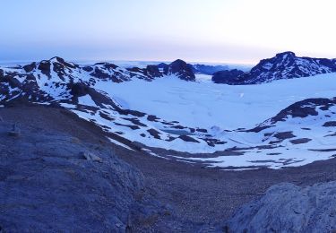
Trail Other activity of 11.2 km to be discovered at Valais/Wallis, Hérens, Ayent. This trail is proposed by sterrettaz.

Description

Départ depuis les Rousses (fond des installations de ski du domaine d''Anzère, côté barrage du Rawyl) en direction de la cabane des Audannes puis du Wildhorn. Possible en 2 jours avec nuit en cabane.

Elevation profile

Positioning

Country:
Switzerland
Region :
Valais/Wallis
Department/Province :
Hérens
Municipality :
Ayent
Location:
Unknown
Start:(UTM)
379678 ; 5132206 (32T) N.

Trails nearby

Trail Walking Crans-Montana - Sentier de Huiton - Photo
Walking
GUIDE+

Walking

Very easy
(2)
Crans-Montana, Valais/Wallis, Sierre, Switzerland
7.1 km | 10.9 km-effort
2h 17min
No
Trail Mountain bike Crans-Montana - Tour des villages - Photo
Mountain bike
GUIDE+

Mountain bike

Very easy
(1)
Crans-Montana, Valais/Wallis, Sierre, Switzerland
23 km | 35 km-effort
3h 0min
Yes
Trail On foot Lens - Cran - Er de Chermignon (Ancien bisse du Ro) - Photo
On foot
GUIDE+

On foot

Easy
Lens, Valais/Wallis, Sierre, Switzerland
6.1 km | 11.5 km-effort
2h 37min
No
Trail On foot Icogne - Pra du taillour-Pas de l'ours - Photo
On foot
GUIDE+

On foot

Easy
Icogne, Valais/Wallis, Sierre, Switzerland
4 km | 7.6 km-effort
1h 42min
No
Trail On foot Icogne - Er de Chermignon-Pra du Taillour - Photo
On foot
GUIDE+

On foot

Easy
Icogne, Valais/Wallis, Sierre, Switzerland
6.4 km | 10.2 km-effort
2h 19min
No
Trail On foot Crans-Montana - Plaine Morte-Les Violettes - Photo
On foot
GUIDE+

On foot

Easy
Crans-Montana, Valais/Wallis, Sierre, Switzerland
4.5 km | 11.5 km-effort
2h 36min
No
Trail Walking Icogne - Bisse du Sillonin - Photo
Walking
GUIDE+

Walking

Very easy
Icogne, Valais/Wallis, Sierre, Switzerland
7.1 km | 9.7 km-effort
2h 15min
No
Trail Mountain bike Crans-Montana - Tour Hauts de Crans - Photo
Mountain bike
GUIDE+

Mountain bike

Very easy
Crans-Montana, Valais/Wallis, Sierre, Switzerland
7.8 km | 11.3 km-effort
1h 30min
Yes
Trail Walking Ayent - Au pied du Wildhorn  - Photo
Walking
pjamin

Walking

Very difficult
(1)
Ayent, Valais/Wallis, Hérens, Switzerland
33 km | 64 km-effort
15h 30min
No


Close
My subscriptions