Trail Horseback riding Goxwiller - Boucle Goxwiller-Heiligenstein- Rosenberg-Gox.  - Photo

Boucle Goxwiller-Heiligenstein- Rosenberg-Gox.

 jmroth
jmroth

User

© OpenStreetMap contributors
Length
Length
9.7 km
Max alt
Max alt
395 m
Uphill gradient
Uphill gradient
249 m
Km-Effort
Km-Effort  
13 km
Min alt
Min alt
167 m
Downhill gradient
Downhill gradient
248 m
Boucle
Boucle
Yes
Creation date :
2020-05-28 07:24:10.728
Updated on :
2020-05-28 09:28:58.699

(0 Reviews)

Horseback riding
Horseback riding
2h00
Difficulty : Medium
Other activity
Other activity
1h20
Difficulty : Medium

Scan this QR Code to open this trail in the SityTrail application

FREE GPS app for hiking

Logo SityTrail SityTrail

IGN / Geographical institutes

Download SityTrail from the App Store Download SityTrail from Google Play

Logo SityTrail SityTrail World

The world is yours!

Download SityTrail from the App Store Download SityTrail from Google Play Download SityTrail on Huawei AppGallery

About

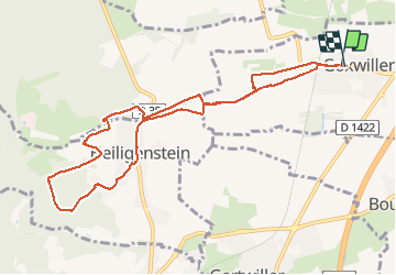
Trail Horseback riding of 9.7 km to be discovered at Grand Est, Bas-Rhin, Goxwiller. This trail is proposed by jmroth.

Description

Départ de Goxwiller
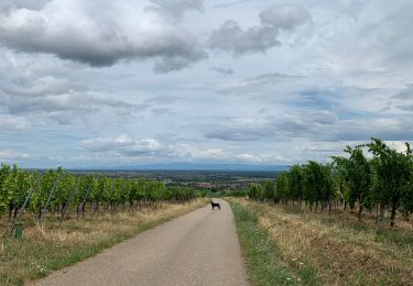
Heiligenstein par les vignes
Passage en forêt
Rosenberg de Heiligenstein
Retour par la route macadam

Elevation profile

Photos

Positioning

Country:
France
Region :
Grand Est
Department/Province :
Bas-Rhin
Municipality :
Goxwiller
Location:
Unknown
Start:(UTM)
387749 ; 5365538 (32U) N.

Trails nearby

Trail Walking Ottrott - Le Mont Sainte-Odile depuis Otrott - Photo
Walking
VacheKiri67

Walking

Medium
(1)
Ottrott, Grand Est, Bas-Rhin, France
13 km | 20 km-effort
6h 18min
Yes
Trail Walking Obernai - Obernai gare - Mont St Odile - Photo
Walking
tracegps

Walking

Difficult
(2)
Obernai, Grand Est, Bas-Rhin, France
20 km | 29 km-effort
5h 0min
Yes
Trail Mountain bike Ottrott - Sainte-Odile East-Face - Photo
Mountain bike
tracegps

Mountain bike

Difficult
(1)
Ottrott, Grand Est, Bas-Rhin, France
24 km | 39 km-effort
3h 0min
Yes
Trail Walking Obernai - sentier des merveilles - Photo
Walking
semila

Walking

Difficult
(1)
Obernai, Grand Est, Bas-Rhin, France
11 km | 16.6 km-effort
4h 8min
Yes
Trail Walking Mittelbergheim - Mittelbergheim - Château du Landsberg - Photo
Walking
tracegps

Walking

Medium
(3)
Mittelbergheim, Grand Est, Bas-Rhin, France
15.4 km | 23 km-effort
5h 0min
Yes
Trail On foot Saint-Nabor - Circuit autour du Mont Ste Odile - Photo
On foot
RichardZ

On foot

Medium
Saint-Nabor, Grand Est, Bas-Rhin, France
13 km | 21 km-effort
4h 43min
Yes
Trail Walking Goxwiller - Goxwiller-Landsberg-Kapellenhausfelsen-Goxwiller - Photo
Walking
Silke Roth

Walking

Medium
Goxwiller, Grand Est, Bas-Rhin, France
17.7 km | 26 km-effort
4h 30min
No
Trail Walking Mittelbergheim - 2023-02-25 Marche Châteaux Andlau Spessbourg Landsberg - Photo
Walking
GUIDE
holtzv

Walking

Very difficult
Mittelbergheim, Grand Est, Bas-Rhin, France
20 km | 30 km-effort
5h 16min
Yes
Trail Walking Andlau - Andlau - château d'Andlau - château du Spesbourg - Photo
Walking
Bart2015

Walking

Easy
Andlau, Grand Est, Bas-Rhin, France
8.6 km | 12.8 km-effort
1h 54min
Yes


Close
My subscriptions