Trail Walking Sentheim - Sentheim Rossberg - Photo

Sentheim Rossberg

 helmut68
helmut68

User

© OpenStreetMap contributors
Length
Length
27 km
Max alt
Max alt
1127 m
Uphill gradient
Uphill gradient
953 m
Km-Effort
Km-Effort  
40 km
Min alt
Min alt
353 m
Downhill gradient
Downhill gradient
954 m
Boucle
Boucle
Yes
Creation date :
2020-06-15 08:31:13.244
Updated on :
2020-07-02 21:47:11.708

(1 Reviews)

Walking
Walking
6h11
Difficulty : Medium

Scan this QR Code to open this trail in the SityTrail application

FREE GPS app for hiking

Logo SityTrail SityTrail

IGN / Geographical institutes

Download SityTrail from the App Store Download SityTrail from Google Play

Logo SityTrail SityTrail World

The world is yours!

Download SityTrail from the App Store Download SityTrail from Google Play Download SityTrail on Huawei AppGallery

About

Trail Walking of 27 km to be discovered at Grand Est, Haut-Rhin, Sentheim. This trail is proposed by helmut68.

Description

Départ place de l'église  de Sentheim, une fois  le pont de la Doller passé suivre le   balisage " rouge blanc rouge "  jusqu'au  Rossberg. Retour par le GR5 jusqu'au Hundsruck. De là reprenez le balisage " rouge blanc rouge " jusqu'au col du Schirm. Retour à Sentheim en suivant le balisage " disque Jaune ".
C'est une belle randonnée, essentiellement sur des chemins forestiers jusqu'aux chaumes du Rossberg (1191m)...
Alors à vos chaussures pour découvrir le rocher du Corbeau, le jardin naturel de Bourbach le Haut, le refuge de la Saeger Hutte et le Rossberg...

Elevation profile

Photos

26 photos in total. Please click on a photo to see them all in the gallery.

Positioning

Country:
France
Region :
Grand Est
Department/Province :
Haut-Rhin
Municipality :
Sentheim
Location:
Unknown
Start:(UTM)
353916 ; 5290648 (32T) N.

Comments

Please log in to post a review or rate the element


Superbe montée du massif Rossberg par le versant adret praticable des les premiers mois de l'année en décrassage hivernal. Abris , refuges de club , auberges et ferme-auberge sur le parcours et possibilités de réduire le 8 du parcours à la première boucle en cas de défaillance... météo ,bien sûr. Point d'orgue: vue sur les Alpes suisses depuis les hauteurs de préférence le matin, généralement plus clair .


Trails nearby

Trail Walking Masevaux-Niederbruck - Masevaux - Rossberg par le belvédère du Fuchsfelsen - Photo
Walking
Bart2015

Walking

Medium
(1)
Masevaux-Niederbruck, Grand Est, Haut-Rhin, France
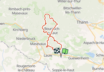
19.9 km | 34 km-effort
4h 44min
Yes
Trail Walking Lauw - 2022-07-14 Marche Lauw Refuge CAF Baerenkopf - Photo
Walking
GUIDE
holtzv

Walking

Very difficult
Lauw, Grand Est, Haut-Rhin, France
18.4 km | 31 km-effort
5h 35min
No
Trail On foot Sentheim - Sentier géologique du Wolfloch - Photo
On foot
PRO

On foot

Easy
Sentheim, Grand Est, Haut-Rhin, France
3.8 km | 4.8 km-effort
1h 5min
No
Trail On foot Sentheim - Sentheim - Bergwald - Eichwald - Guevenheim - Sentheim - Photo
On foot
patrickbeyrath

On foot

Easy
(1)
Sentheim, Grand Est, Haut-Rhin, France
13.4 km | 16.6 km-effort
Unknown
Yes
Trail Walking Sentheim - Knapphutte Saegenkopf Hütte - Photo
Walking
helmut68

Walking

Medium
Sentheim, Grand Est, Haut-Rhin, France
13.8 km | 17.2 km-effort
5h 11min
Yes
Trail Walking Sentheim - Montori - Photo
Walking
helmut68

Walking

Medium
Sentheim, Grand Est, Haut-Rhin, France
17.7 km | 24 km-effort
4h 47min
Yes
Trail Mountain bike Sentheim - AperoDioller - Photo
Mountain bike
helmut68

Mountain bike

Easy
Sentheim, Grand Est, Haut-Rhin, France
24 km | 27 km-effort
1h 23min
Yes
Trail Walking Sentheim - Baerenkopf  - Photo
Walking
helmut68

Walking

Difficult
Sentheim, Grand Est, Haut-Rhin, France
33 km | 49 km-effort
7h 0min
Yes
Trail Walking Sentheim - Lac Seigneurie Soultzbach - Photo
Walking
helmut68

Walking

Easy
Sentheim, Grand Est, Haut-Rhin, France
10.9 km | 12.7 km-effort
3h 26min
Yes


Close
My subscriptions