


PETIT HONECK

surceneux
User
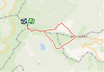

Length
5.9 km

Max alt
1355 m

Uphill gradient
351 m
Km-Effort
10.6 km

Min alt
1001 m

Downhill gradient
350 m
Boucle
Yes
Creation date :
2020-06-22 13:04:58.074
Updated on :
2020-06-22 16:43:32.56
1h30
Difficulty : Medium

FREE GPS app for hiking
 SityTrail
IGN / Geographical institutes
SityTrail Plus
The world is yours!
About
Trail Walking of 5.9 km to be discovered at Grand Est, Haut-Rhin, Stosswihr. This trail is proposed by surceneux.
Description
TOUR DU PETIT HOHNECK RECTANGLE ROUGE GR5 SCHAFFERTHAL SCHIESSROTH GACHNEY SCHELLERN SCHAFFERTHAL HOHNECK
Positioning
Country:
France
Region :
Grand Est
Department/Province :
Haut-Rhin
Municipality :
Stosswihr
Location:
Unknown
Start:(Dec)
Start:(UTM)
352116 ; 5322405 (32U) N.
Comments