Trail Walking Vaux-en-Beaujolais - Vaulx en beaujolais  - Photo
 aurel69
aurel69

User

© OpenStreetMap contributors
Length
Length
14.3 km
Max alt
Max alt
668 m
Uphill gradient
Uphill gradient
581 m
Km-Effort
Km-Effort  
22 km
Min alt
Min alt
291 m
Downhill gradient
Downhill gradient
572 m
Boucle
Boucle
Yes
Creation date :
2020-07-12 06:38:56.0
Updated on :
2020-07-12 11:06:21.726

(1 Reviews)

Walking
Walking
4h25
Difficulty : Easy

Scan this QR Code to open this trail in the SityTrail application

FREE GPS app for hiking

Logo SityTrail SityTrail

IGN / Geographical institutes

Download SityTrail from the App Store Download SityTrail from Google Play

Logo SityTrail SityTrail World

The world is yours!

Download SityTrail from the App Store Download SityTrail from Google Play Download SityTrail on Huawei AppGallery

About

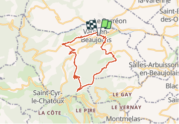
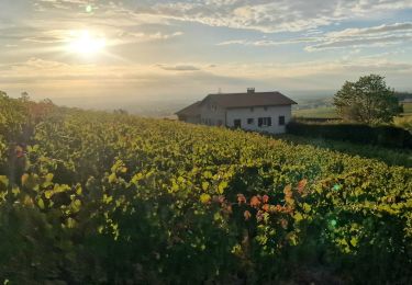
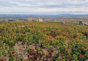
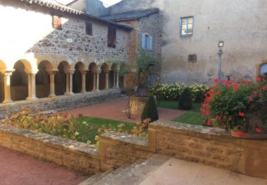
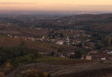
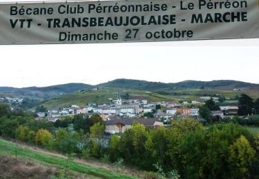
Trail Walking of 14.3 km to be discovered at Auvergne-Rhône-Alpes, Rhône, Vaux-en-Beaujolais. This trail is proposed by aurel69.

Description

Rando sympathique sans trop de difficultés.
Attention peu d’ombre sur le parcours

Elevation profile

Photos

Positioning

Country:
France
Region :
Auvergne-Rhône-Alpes
Department/Province :
Rhône
Municipality :
Vaux-en-Beaujolais
Location:
Unknown
Start:(UTM)
623235 ; 5101517 (31T) N.

Comments

Please log in to post a review or rate the element


Trails nearby

Trail Walking Montmelas-Saint-Sorlin - Col de Saint Bonnet (13-09-18)  - Photo
Walking
Thomasdanielle

Walking

Easy
(1)
Montmelas-Saint-Sorlin, Auvergne-Rhône-Alpes, Rhône, France
8.1 km | 11.9 km-effort
2h 29min
Yes
Trail Walking Saint-Cyr-le-Chatoux - Saint-cyr-le-Chatoux
Walking
Thomasdanielle

Walking

Medium
(2)
Saint-Cyr-le-Chatoux, Auvergne-Rhône-Alpes, Rhône, France
11.7 km | 16.7 km-effort
3h 45min
Yes
Trail On foot Odenas - SityTrail - 3844657 - etape-3 (1) - Photo
On foot
chessyca

On foot

Difficult
Odenas, Auvergne-Rhône-Alpes, Rhône, France
23 km | 36 km-effort
8h 13min
No
Trail On foot Vaux-en-Beaujolais - SityTrail - 3843016 - etape-2 - Photo
On foot
chessyca

On foot

Very difficult
Vaux-en-Beaujolais, Auvergne-Rhône-Alpes, Rhône, France
22 km | 35 km-effort
7h 58min
No
Trail Walking Salles-Arbuissonnas-en-Beaujolais - Salles-Arbuissonnas-en-Beaujolais - Photo
Walking
Thomasdanielle

Walking

Easy
Salles-Arbuissonnas-en-Beaujolais, Auvergne-Rhône-Alpes, Rhône, France
16.4 km | 23 km-effort
4h 55min
Yes
Trail Walking Le Perréon - le Perréon (69) - Photo
Walking
Thomasdanielle

Walking

Easy
Le Perréon, Auvergne-Rhône-Alpes, Rhône, France
10.8 km | 16.5 km-effort
3h 17min
Yes
Trail Mountain bike Le Perréon - La 22ème Transbeaujolaise (2013-VTT-40km) - Le Perréon - Photo
Mountain bike
tracegps

Mountain bike

Difficult
Le Perréon, Auvergne-Rhône-Alpes, Rhône, France
37 km | 48 km-effort
4h 0min
Yes
Trail Mountain bike Le Perréon - La 22ème Transbeaujolaise (2013-VTT-60km) - Le Perréon - Photo
Mountain bike
tracegps

Mountain bike

Very difficult
Le Perréon, Auvergne-Rhône-Alpes, Rhône, France
55 km | 76 km-effort
5h 0min
Yes
Trail Walking Montmelas-Saint-Sorlin - Col de Saint Bonnet (11 km - D. 377 m) - Photo
Walking
Thomasdanielle

Walking

Difficult
(1)
Montmelas-Saint-Sorlin, Auvergne-Rhône-Alpes, Rhône, France
11.2 km | 16.2 km-effort
3h 41min
Yes


Close
My subscriptions