Trail Walking Saint-Cyr-le-Chatoux - Saint-cyr-le-Chatoux

Saint-cyr-le-Chatoux "Les Agneaux"

© OpenStreetMap contributors
Length
Length
11.7 km
Max alt
Max alt
758 m
Uphill gradient
Uphill gradient
372 m
Km-Effort
Km-Effort  
16.7 km
Min alt
Min alt
489 m
Downhill gradient
Downhill gradient
372 m
Boucle
Boucle
Yes
Creation date :
2018-04-17 16:56:58.991
Updated on :
2018-04-17 16:56:58.991

(2 Reviews)

Walking
Walking
3h45
Difficulty : Medium

Scan this QR Code to open this trail in the SityTrail application

FREE GPS app for hiking

Logo SityTrail SityTrail

IGN / Geographical institutes

Download SityTrail from the App Store Download SityTrail from Google Play

Logo SityTrail SityTrail World

The world is yours!

Download SityTrail from the App Store Download SityTrail from Google Play Download SityTrail on Huawei AppGallery

About

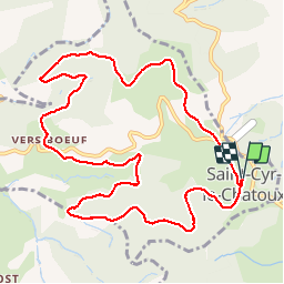
Trail Walking of 11.7 km to be discovered at Auvergne-Rhône-Alpes, Rhône, Saint-Cyr-le-Chatoux. This trail is proposed by Thomasdanielle.

Description

D/A : Parking du cimetière (proche école)
Circuit : suivre les panneaux en jaune "Les agneaux"
11,7 km - D. 485 m

Elevation profile

Positioning

Country:
France
Region :
Auvergne-Rhône-Alpes
Department/Province :
Rhône
Municipality :
Saint-Cyr-le-Chatoux
Location:
Unknown
Start:(UTM)
620509 ; 5098287 (31T) N.

Comments

Please log in to post a review or rate the element


Facile et beaux points de vue.


Trails nearby

Trail Walking Montmelas-Saint-Sorlin - Col de Saint Bonnet (13-09-18)  - Photo
Walking
Thomasdanielle

Walking

Easy
(1)
Montmelas-Saint-Sorlin, Auvergne-Rhône-Alpes, Rhône, France
8.1 km | 11.9 km-effort
2h 29min
Yes
Trail Walking Rivolet - Rivolet - Photo
Walking
jpcoco

Walking

Medium
(2)
Rivolet, Auvergne-Rhône-Alpes, Rhône, France
11.1 km | 17.2 km-effort
3h 42min
No
Trail On foot Vaux-en-Beaujolais - SityTrail - 3843016 - etape-2 - Photo
On foot
chessyca

On foot

Very difficult
Vaux-en-Beaujolais, Auvergne-Rhône-Alpes, Rhône, France
22 km | 35 km-effort
7h 58min
No
Trail Walking Vaux-en-Beaujolais - Vaulx en beaujolais  - Photo
Walking
aurel69

Walking

Easy
(1)
Vaux-en-Beaujolais, Auvergne-Rhône-Alpes, Rhône, France
14.3 km | 22 km-effort
4h 25min
Yes
Trail Walking Le Perréon - le Perréon (69) - Photo
Walking
Thomasdanielle

Walking

Easy
Le Perréon, Auvergne-Rhône-Alpes, Rhône, France
10.8 km | 16.5 km-effort
3h 17min
Yes
Trail Mountain bike Le Perréon - La 22ème Transbeaujolaise (2013-VTT-40km) - Le Perréon - Photo
Mountain bike
tracegps

Mountain bike

Difficult
Le Perréon, Auvergne-Rhône-Alpes, Rhône, France
37 km | 48 km-effort
4h 0min
Yes
Trail Mountain bike Le Perréon - La 22ème Transbeaujolaise (2013-VTT-60km) - Le Perréon - Photo
Mountain bike
tracegps

Mountain bike

Very difficult
Le Perréon, Auvergne-Rhône-Alpes, Rhône, France
55 km | 76 km-effort
5h 0min
Yes
Trail Walking Montmelas-Saint-Sorlin - Col de Saint Bonnet (11 km - D. 377 m) - Photo
Walking
Thomasdanielle

Walking

Difficult
(1)
Montmelas-Saint-Sorlin, Auvergne-Rhône-Alpes, Rhône, France
11.2 km | 16.2 km-effort
3h 41min
Yes
Trail Walking Sainte-Paule - Col du chêne  (8,6km - D. 275 m) - Photo
Walking
Thomasdanielle

Walking

Medium
Sainte-Paule, Auvergne-Rhône-Alpes, Rhône, France
8.6 km | 12.3 km-effort
2h 23min
Yes


Close
My subscriptions