Trail Mountain bike Bussière-Galant - lac bussiere galant - Photo
 mouss65
mouss65

User

© OpenStreetMap contributors
Length
Length
11.2 km
Max alt
Max alt
454 m
Uphill gradient
Uphill gradient
168 m
Km-Effort
Km-Effort  
13.5 km
Min alt
Min alt
387 m
Downhill gradient
Downhill gradient
182 m
Boucle
Boucle
No
Creation date :
2020-07-19 15:32:25.166
Updated on :
2020-07-19 16:35:28.275

(0 Reviews)

Mountain bike
Mountain bike
1h02
Difficulty : Easy

Scan this QR Code to open this trail in the SityTrail application

FREE GPS app for hiking

Logo SityTrail SityTrail

IGN / Geographical institutes

Download SityTrail from the App Store Download SityTrail from Google Play

Logo SityTrail SityTrail World

The world is yours!

Download SityTrail from the App Store Download SityTrail from Google Play Download SityTrail on Huawei AppGallery

About

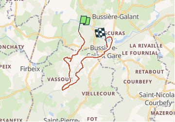
Trail Mountain bike of 11.2 km to be discovered at New Aquitaine, Haute-Vienne, Bussière-Galant. This trail is proposed by mouss65.

Elevation profile

Positioning

Country:
France
Region :
New Aquitaine
Department/Province :
Haute-Vienne
Municipality :
Bussière-Galant
Location:
Unknown
Start:(UTM)
344866 ; 5053672 (31T) N.

Trails nearby

Trail Walking Firbeix - Astier_Coquille_Firbeix - Photo
Walking
kmedone

Walking

Difficult
(3)
Firbeix, New Aquitaine, Dordogne, France
94 km | 116 km-effort
23h 55min
No
Trail Walking Bussière-Galant - Le sentiers des Demoiselles - Photo
Walking
viam19

Walking

Medium
(1)
Bussière-Galant, New Aquitaine, Haute-Vienne, France
14.9 km | 19.5 km-effort
5h 54min
Yes
Trail Walking Saint-Pierre-de-Frugie - Montcigoux - Photo
Walking
ace003

Walking

Easy
Saint-Pierre-de-Frugie, New Aquitaine, Dordogne, France
5.9 km | 7.2 km-effort
1h 26min
Yes
Trail Walking Bussière-Galant - st nicolas  - Photo
Walking
vignaud

Walking

Very easy
Bussière-Galant, New Aquitaine, Haute-Vienne, France
15.3 km | 19.2 km-effort
3h 53min
No
Trail Walking Bussière-Galant - st courbefy - Photo
Walking
Mamidomi

Walking

Difficult
Bussière-Galant, New Aquitaine, Haute-Vienne, France
11.4 km | 15.1 km-effort
3h 25min
Yes
Trail Walking Châlus - 19042022 - Photo
Walking
bernie88

Walking

Medium
Châlus, New Aquitaine, Haute-Vienne, France
20 km | 25 km-effort
7h 23min
No
Trail Walking Châlus - chalus-la coquille  - Photo
Walking
pivol

Walking

Medium
Châlus, New Aquitaine, Haute-Vienne, France
18.4 km | 23 km-effort
5h 45min
No
Trail Walking Bussière-Galant -  courbefy fournial 8k7 3oct19 - Photo
Walking
PhilMarie

Walking

Very easy
(1)
Bussière-Galant, New Aquitaine, Haute-Vienne, France
19.9 km | 26 km-effort
2h 37min
Yes
Trail Cycle Châlus - 4 chalus Bergerac - Photo
Cycle
henri.cordier

Cycle

Very easy
Châlus, New Aquitaine, Haute-Vienne, France
124 km | 148 km-effort
Unknown
No


Close
My subscriptions