Trail Nordic walking Beynat - lac des miel - Roche de vic - Photo

lac des miel - Roche de vic

© OpenStreetMap contributors
Length
Length
16.3 km
Max alt
Max alt
626 m
Uphill gradient
Uphill gradient
387 m
Km-Effort
Km-Effort  
21 km
Min alt
Min alt
429 m
Downhill gradient
Downhill gradient
389 m
Boucle
Boucle
Yes
Creation date :
2020-08-15 05:43:23.949
Updated on :
2020-08-15 09:10:53.953

(0 Reviews)

Nordic walking
Nordic walking
3h10
Difficulty : Easy

Scan this QR Code to open this trail in the SityTrail application

FREE GPS app for hiking

Logo SityTrail SityTrail

IGN / Geographical institutes

Download SityTrail from the App Store Download SityTrail from Google Play

Logo SityTrail SityTrail World

The world is yours!

Download SityTrail from the App Store Download SityTrail from Google Play Download SityTrail on Huawei AppGallery

About

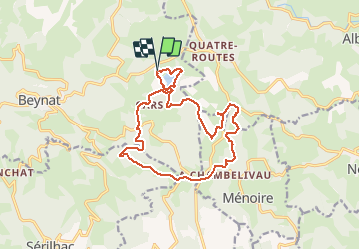
Trail Nordic walking of 16.3 km to be discovered at New Aquitaine, Corrèze, Beynat. This trail is proposed by joebartwix.

Description

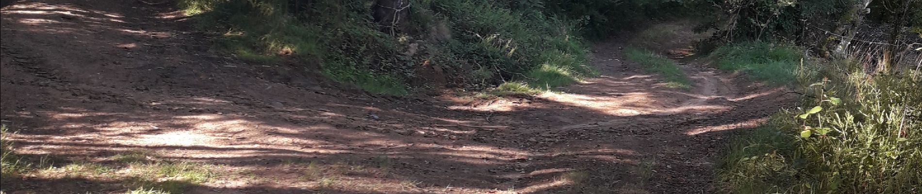
A la photo,  prendre à gauche. Erreur balisage.

Elevation profile

Photos

Positioning

Country:
France
Region :
New Aquitaine
Department/Province :
Corrèze
Municipality :
Beynat
Location:
Unknown
Start:(UTM)
402702 ; 4998358 (31T) N.

Trails nearby

Trail Mountain bike Chenailler-Mascheix - Roche de Vic depuis Mascheix - Photo
Mountain bike
Djebel

Mountain bike

Easy
(1)
Chenailler-Mascheix, New Aquitaine, Corrèze, France
13.2 km | 17.5 km-effort
1h 8min
Yes
Trail Walking Ménoire - menoir 2 - Photo
Walking
chanac les mines

Walking

Difficult
Ménoire, New Aquitaine, Corrèze, France
11.3 km | 14.8 km-effort
3h 18min
Yes
Trail Walking Sérilhac - SityTrail - La Sérilhacoise Grande Rando   - Photo
Walking
Gpoujade

Walking

Difficult
Sérilhac, New Aquitaine, Corrèze, France
8.7 km | 13.8 km-effort
3h 8min
Yes
Trail Walking Sérilhac - La Sérilhacoise Grande Rando   - Photo
Walking
Gpoujade

Walking

Very difficult
Sérilhac, New Aquitaine, Corrèze, France
16.2 km | 23 km-effort
5h 19min
Yes
Trail Mountain bike Beynat - SityTrail - 3810281 - or-vtt-30km - Photo
Mountain bike
Gpoujade

Mountain bike

Difficult
Beynat, New Aquitaine, Corrèze, France
29 km | 39 km-effort
2h 40min
Yes
Trail Walking Ménoire - SityTrail - gorges de mémoire et cascade gourlastine - Photo
Walking
Gpoujade

Walking

Difficult
Ménoire, New Aquitaine, Corrèze, France
10.6 km | 15 km-effort
3h 24min
Yes
Trail Walking Albussac - roche vicq - Photo
Walking
personono

Walking

Difficult
Albussac, New Aquitaine, Corrèze, France
10.4 km | 13.7 km-effort
2h 40min
No
Trail Mountain bike Sérilhac - LA BELLE RANDONNEE DE SERILHAC  - Photo
Mountain bike
Gpoujade

Mountain bike

Difficult
Sérilhac, New Aquitaine, Corrèze, France
25 km | 34 km-effort
2h 38min
Yes
Trail Nordic walking Beynat - territoire de l'ancienne commanderie de Puy de Noix  - Photo
Nordic walking
joebartwix

Nordic walking

Very easy
Beynat, New Aquitaine, Corrèze, France
9 km | 12 km-effort
1h 38min
Yes


Close
My subscriptions