Trail Walking Sixt-Fer-à-Cheval - 2020-08-15 Marche Refuge Grenairon Le Mont Buet Les Fonts Salvagny - Photo

2020-08-15 Marche Refuge Grenairon Le Mont Buet Les Fonts Salvagny

 holtzv
holtzv

User GUIDE

© OpenStreetMap contributors
Length
Length
20 km
Max alt
Max alt
3083 m
Uphill gradient
Uphill gradient
1239 m
Km-Effort
Km-Effort  
40 km
Min alt
Min alt
932 m
Downhill gradient
Downhill gradient
2260 m
Boucle
Boucle
No
Creation date :
2020-08-15 03:03:38.523
Updated on :
2020-08-17 10:20:29.547

(0 Reviews)

Walking
Walking
12h24
Difficulty : Very easy

Scan this QR Code to open this trail in the SityTrail application

FREE GPS app for hiking

Logo SityTrail SityTrail

IGN / Geographical institutes

Download SityTrail from the App Store Download SityTrail from Google Play

Logo SityTrail SityTrail World

The world is yours!

Download SityTrail from the App Store Download SityTrail from Google Play Download SityTrail on Huawei AppGallery

About

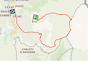
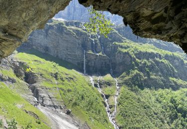
Trail Walking of 20 km to be discovered at Auvergne-Rhône-Alpes, Upper Savoy, Sixt-Fer-à-Cheval. This trail is proposed by holtzv.

Description

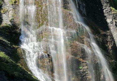
Départ à 5h du Refuge de Grenairon pour l'ascension du Mont Buet en passant par la Cathédrale,  le lac du Plan du Buet, la crète de la montagne des Eves.
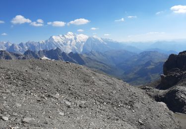
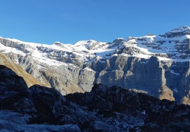
Arrivée au sommet du Mont Buet à 3100m à 10h.
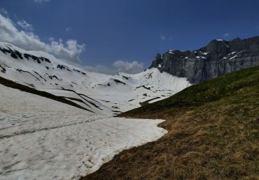
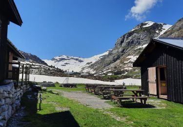
Descente de 2260m de d- par le Grenier de Villy, les Beaux prés, le refuge des Fonts pour une petite mousse, et retour aux voitures à Salvagny.

Elevation profile

Photos

Positioning

Country:
France
Region :
Auvergne-Rhône-Alpes
Department/Province :
Upper Savoy
Municipality :
Sixt-Fer-à-Cheval
Location:
Unknown
Start:(UTM)
329599 ; 5099988 (32T) N.

Trails nearby

Trail Walking Sixt-Fer-à-Cheval - Lac d'Anterne - Photo
Walking
i20

Walking

Medium
(1)
Sixt-Fer-à-Cheval, Auvergne-Rhône-Alpes, Upper Savoy, France
19.8 km | 37 km-effort
5h 9min
Yes
Trail Walking Sixt-Fer-à-Cheval - Gorges des Tines - Gers - Samoens  - Photo
Walking
GUIDE
Kargil

Walking

Difficult
Sixt-Fer-à-Cheval, Auvergne-Rhône-Alpes, Upper Savoy, France
18.6 km | 33 km-effort
5h 52min
Yes
Trail Walking Sixt-Fer-à-Cheval - J9GR5Nord - Photo
Walking
annehc

Walking

Very difficult
Sixt-Fer-à-Cheval, Auvergne-Rhône-Alpes, Upper Savoy, France
16.8 km | 29 km-effort
6h 36min
No
Trail Walking Sixt-Fer-à-Cheval - SIXT PASSY RESERVE: CHALETS DE SALES 2 - Photo
Walking
djeepee74

Walking

Medium
Sixt-Fer-à-Cheval, Auvergne-Rhône-Alpes, Upper Savoy, France
11.5 km | 21 km-effort
4h 50min
Yes
Trail Walking Sixt-Fer-à-Cheval - SIXT PASSY RESERVE: LE BUET MONTEE VIA GRENAIRON - RETOUR PAR LES FONDS - Photo
Walking
djeepee74

Walking

Very difficult
Sixt-Fer-à-Cheval, Auvergne-Rhône-Alpes, Upper Savoy, France
26 km | 56 km-effort
8h 42min
Yes
Trail Walking Sixt-Fer-à-Cheval - Refuge et Lac d'Anterne - Photo
Walking
GuyVachet

Walking

Very difficult
Sixt-Fer-à-Cheval, Auvergne-Rhône-Alpes, Upper Savoy, France
13.9 km | 28 km-effort
6h 59min
Yes
Trail Walking Sixt-Fer-à-Cheval - Refuge de Sales - Photo
Walking
GuyVachet

Walking

Difficult
Sixt-Fer-à-Cheval, Auvergne-Rhône-Alpes, Upper Savoy, France
12 km | 22 km-effort
7h 3min
Yes
Trail Walking Sixt-Fer-à-Cheval - Le bout du monde Sixt fer à cheval - Photo
Walking
daniel34

Walking

Medium
Sixt-Fer-à-Cheval, Auvergne-Rhône-Alpes, Upper Savoy, France
11.9 km | 18.7 km-effort
3h 10min
Yes
Trail Walking Sixt-Fer-à-Cheval - lac de la Vogealle par le pas du Boret - Photo
Walking
arianespace

Walking

Difficult
Sixt-Fer-à-Cheval, Auvergne-Rhône-Alpes, Upper Savoy, France
19.2 km | 35 km-effort
8h 0min
Yes


Close
My subscriptions