Trail Mountain bike Montfaucon-en-Velay - Via Fluvia de Montfaucon au tunnel de Tracol - Photo

Via Fluvia de Montfaucon au tunnel de Tracol

© OpenStreetMap contributors
Length
Length
33 km
Max alt
Max alt
927 m
Uphill gradient
Uphill gradient
573 m
Km-Effort
Km-Effort  
40 km
Min alt
Min alt
781 m
Downhill gradient
Downhill gradient
573 m
Boucle
Boucle
Yes
Creation date :
2020-08-18 06:26:08.0
Updated on :
2020-08-18 09:08:21.255

(0 Reviews)

Mountain bike
Mountain bike
2h41
Difficulty : Very easy

Scan this QR Code to open this trail in the SityTrail application

FREE GPS app for hiking

Logo SityTrail SityTrail

IGN / Geographical institutes

Download SityTrail from the App Store Download SityTrail from Google Play

Logo SityTrail SityTrail World

The world is yours!

Download SityTrail from the App Store Download SityTrail from Google Play Download SityTrail on Huawei AppGallery

About

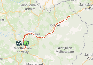
Trail Mountain bike of 33 km to be discovered at Auvergne-Rhône-Alpes, Haute-Loire, Montfaucon-en-Velay. This trail is proposed by Pat_83200.

Description

Par Dunières.

Elevation profile

Photos

Positioning

Country:
France
Region :
Auvergne-Rhône-Alpes
Department/Province :
Haute-Loire
Municipality :
Montfaucon-en-Velay
Location:
Unknown
Start:(UTM)
603331 ; 5004579 (31T) N.

Trails nearby

Trail Mountain bike Montregard - Espace VTT FFC Le Velay des 3 Rivières - N°15 Le Ruisseau de Trifoulou Montregard - Photo
Mountain bike
tracegps

Mountain bike

Medium
(1)
Montregard, Auvergne-Rhône-Alpes, Haute-Loire, France
17.7 km | 23 km-effort
2h 0min
Yes
Trail Walking Montregard - Rando t'est  - Photo
Walking
jroche425@gmail.com

Walking

Easy
(1)
Montregard, Auvergne-Rhône-Alpes, Haute-Loire, France
1.1 km | 1.2 km-effort
19min
Yes
Trail Walking Saint-Pal-de-Mons - chapelle ste julien-7 km - Photo
Walking
famillerudent

Walking

Medium
Saint-Pal-de-Mons, Auvergne-Rhône-Alpes, Haute-Loire, France
7.1 km | 10.5 km-effort
2h 13min
Yes
Trail Walking Montfaucon-en-Velay - Jakobsweg 2014-1 - Photo
Walking
martinstalder

Walking

Easy
(2)
Montfaucon-en-Velay, Auvergne-Rhône-Alpes, Haute-Loire, France
18.7 km | 25 km-effort
5h 22min
No
Trail Mountain bike Dunières - voie verte Duniere Tracol - Photo
Mountain bike
bena42

Mountain bike

Very easy
Dunières, Auvergne-Rhône-Alpes, Haute-Loire, France
21 km | 25 km-effort
3h 48min
Yes
Trail Walking Raucoules - Circuit des Jeannettes - Photo
Walking
Pat_83200

Walking

Very easy
(1)
Raucoules, Auvergne-Rhône-Alpes, Haute-Loire, France
3.5 km | 4.6 km-effort
1h 5min
Yes
Trail Walking Saint-Pal-de-Mons - La Chapelle St Julien 2017 04 15 - Photo
Walking
psesjs

Walking

Medium
Saint-Pal-de-Mons, Auvergne-Rhône-Alpes, Haute-Loire, France
8.3 km | 13.1 km-effort
2h 45min
Yes
Trail Walking Saint-Pal-de-Mons - La Chapelle St Julien 2017 04 15 - Photo
Walking
psesjs

Walking

Medium
Saint-Pal-de-Mons, Auvergne-Rhône-Alpes, Haute-Loire, France
8.3 km | 13.1 km-effort
2h 45min
Yes
Trail Walking Saint-Pal-de-Mons - La Chapelle St Julien 2017 04 15 - Photo
Walking
psesjs

Walking

Medium
Saint-Pal-de-Mons, Auvergne-Rhône-Alpes, Haute-Loire, France
8.3 km | 13.1 km-effort
2h 45min
Yes


Close
My subscriptions