Trail On foot Pontécoulant - Pontecoulant - Photo

ensemble sur les chemins

© OpenStreetMap contributors
Length
Length
4.3 km
Max alt
Max alt
241 m
Uphill gradient
Uphill gradient
124 m
Km-Effort
Km-Effort  
6 km
Min alt
Min alt
134 m
Downhill gradient
Downhill gradient
122 m
Boucle
Boucle
Yes
Creation date :
2020-09-22 13:02:13.032
Updated on :
2020-09-22 13:06:31.965

(0 Reviews)

On foot
On foot
--
Difficulty : Medium

Scan this QR Code to open this trail in the SityTrail application

FREE GPS app for hiking

Logo SityTrail SityTrail

IGN / Geographical institutes

Download SityTrail from the App Store Download SityTrail from Google Play

Logo SityTrail SityTrail World

The world is yours!

Download SityTrail from the App Store Download SityTrail from Google Play Download SityTrail on Huawei AppGallery

About

Trail On foot of 4.3 km to be discovered at Normandy, Calvados, Pontécoulant. This trail is proposed by AACLARANDO.

Description

départ du chateau de Pontecoulant. Direction le point de vue, puis l'Aitre, le Bosq Hamon et retour le chareau.

Elevation profile

Positioning

Country:
France
Region :
Normandy
Department/Province :
Calvados
Municipality :
Pontécoulant
Location:
Unknown
Start:(UTM)
676562 ; 5418769 (30U) N.

Trails nearby

Trail On foot Condé-en-Normandie - La Chapelle Engerbold - Photo
On foot
PRO

On foot

Easy
Condé-en-Normandie, Normandy, Calvados, France
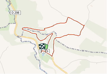
4.3 km | 5.8 km-effort
1h 18min
Yes
Trail On foot Terres de Druance - Le Moulin du Boeuf - Photo
On foot
PRO

On foot

Easy
Terres de Druance, Normandy, Calvados, France
6.1 km | 7.9 km-effort
1h 47min
Yes
Trail On foot Terres de Druance - Tour du Bourg - Photo
On foot
PRO

On foot

Easy
Terres de Druance, Normandy, Calvados, France
3.3 km | 4.2 km-effort
57min
Yes
Trail On foot Condé-en-Normandie - Sur les Traces de la Dame Blanche - Photo
On foot
PRO

On foot

Easy
Condé-en-Normandie, Normandy, Calvados, France
3.2 km | 4.2 km-effort
56min
No
Trail On foot Condé-en-Normandie - Vallée de la Druance - Photo
On foot
PRO

On foot

Easy
Condé-en-Normandie, Normandy, Calvados, France
4.1 km | 5.2 km-effort
1h 11min
No
Trail On foot Condé-en-Normandie - A la Découverte des
On foot
PRO

On foot

Easy
Condé-en-Normandie, Normandy, Calvados, France
10.4 km | 13.6 km-effort
3h 5min
Yes
Trail On foot La Villette - Vers la
On foot
PRO

On foot

Easy
La Villette, Normandy, Calvados, France
4.5 km | 6.3 km-effort
1h 25min
Yes
Trail On foot Condé-en-Normandie - Chemins Creux E - Photo
On foot
PRO

On foot

Easy
Condé-en-Normandie, Normandy, Calvados, France
6.6 km | 8.2 km-effort
1h 51min
Yes
Trail On foot Périgny - Chemins Creux C - Photo
On foot
PRO

On foot

Easy
Périgny, Normandy, Calvados, France
4.2 km | 5.1 km-effort
1h 10min
Yes


Close
My subscriptions