Trail Walking Conat - 20200924 depuis Conat - Photo

20200924 depuis Conat

 ThonyM
ThonyM

User

© OpenStreetMap contributors
Length
Length
14.1 km
Max alt
Max alt
1093 m
Uphill gradient
Uphill gradient
659 m
Km-Effort
Km-Effort  
23 km
Min alt
Min alt
509 m
Downhill gradient
Downhill gradient
656 m
Boucle
Boucle
Yes
Creation date :
2020-09-24 05:37:04.0
Updated on :
2020-09-24 11:05:44.022

(0 Reviews)

Walking
Walking
4h11
Difficulty : Medium

Scan this QR Code to open this trail in the SityTrail application

FREE GPS app for hiking

Logo SityTrail SityTrail

IGN / Geographical institutes

Download SityTrail from the App Store Download SityTrail from Google Play

Logo SityTrail SityTrail World

The world is yours!

Download SityTrail from the App Store Download SityTrail from Google Play Download SityTrail on Huawei AppGallery

About

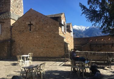
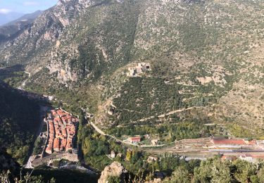
Trail Walking of 14.1 km to be discovered at Occitania, Pyrénées-Orientales, Conat. This trail is proposed by ThonyM.

Description

Superbe parcours rempli d’histoire. Un peu sportif

Elevation profile

Photos

Positioning

Country:
France
Region :
Occitania
Department/Province :
Pyrénées-Orientales
Municipality :
Conat
Location:
Unknown
Start:(UTM)
447360 ; 4718034 (31T) N.

Trails nearby

Trail Walking Ria-Sirach - Sirach-Taurinya-Saint Michel de Cuxa - Photo
Walking
ThonyM

Walking

Easy
(2)
Ria-Sirach, Occitania, Pyrénées-Orientales, France
13.5 km | 17.2 km-effort
2h 31min
Yes
Trail Motor Codalet - Prades - Villefranche de Conflent - Evol  - Photo
Motor
crijack

Motor

Easy
(1)
Codalet, Occitania, Pyrénées-Orientales, France
36 km | 48 km-effort
3h 47min
No
Trail Mountain bike Ria-Sirach - cami del pi - Photo
Mountain bike
fine66

Mountain bike

Very easy
(1)
Ria-Sirach, Occitania, Pyrénées-Orientales, France
11.2 km | 18.4 km-effort
1h 52min
Yes
Trail Walking Fuilla - Ville franche / fort Liberia /Chapelle St André de Bell lloc / St esteve de calmeilles - Photo
Walking
robertperello

Walking

Medium
Fuilla, Occitania, Pyrénées-Orientales, France
11.5 km | 21 km-effort
3h 39min
Yes
Trail Walking Codalet - taurinya tour de corts - Photo
Walking
66Gribouille83

Walking

Very difficult
Codalet, Occitania, Pyrénées-Orientales, France
12.7 km | 19.2 km-effort
6h 16min
Yes
Trail Walking Ria-Sirach - 20221117 une boucle depuis Sirach - Photo
Walking
ThonyM

Walking

Difficult
Ria-Sirach, Occitania, Pyrénées-Orientales, France
18.5 km | 33 km-effort
5h 24min
Yes
Trail Walking Ria-Sirach - 20221018 Redoute-Bergerie depuis Camping Sirach - Photo
Walking
ThonyM

Walking

Medium
Ria-Sirach, Occitania, Pyrénées-Orientales, France
10.2 km | 15.5 km-effort
2h 38min
Yes
Trail Walking Serdinya - flassa. taratera 850 positif 13km 4h30 - Photo
Walking
Erius

Walking

Very difficult
Serdinya, Occitania, Pyrénées-Orientales, France
13.8 km | 25 km-effort
4h 21min
Yes
Trail Walking Fuilla - 20220112 horts  - Photo
Walking
ThonyM

Walking

Difficult
Fuilla, Occitania, Pyrénées-Orientales, France
14.6 km | 27 km-effort
4h 31min
Yes


Close
My subscriptions