Trail Walking Ardoix - 07 ardoix - Photo
© OpenStreetMap contributors
Length
Length
18.2 km
Max alt
Max alt
454 m
Uphill gradient
Uphill gradient
427 m
Km-Effort
Km-Effort  
24 km
Min alt
Min alt
276 m
Downhill gradient
Downhill gradient
429 m
Boucle
Boucle
Yes
Creation date :
2020-09-24 07:26:38.883
Updated on :
2020-09-24 13:23:40.557

(0 Reviews)

Walking
Walking
4h29
Difficulty : Easy

Scan this QR Code to open this trail in the SityTrail application

FREE GPS app for hiking

Logo SityTrail SityTrail

IGN / Geographical institutes

Download SityTrail from the App Store Download SityTrail from Google Play

Logo SityTrail SityTrail World

The world is yours!

Download SityTrail from the App Store Download SityTrail from Google Play Download SityTrail on Huawei AppGallery

About

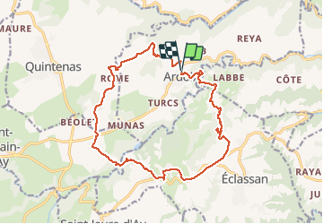
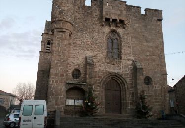
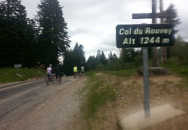
Trail Walking of 18.2 km to be discovered at Auvergne-Rhône-Alpes, Ardèche, Ardoix. This trail is proposed by himba26100.

Description

bcp de goudron
24 09 2020
Joëlle jack gene

Elevation profile

Positioning

Country:
France
Region :
Auvergne-Rhône-Alpes
Department/Province :
Ardèche
Municipality :
Ardoix
Location:
Unknown
Start:(UTM)
636432 ; 5005261 (31T) N.

Trails nearby

Trail Walking Sarras - F07 Sarras Ardoix 2013 12 - Photo
Walking
ageo

Walking

Easy
(3)
Sarras, Auvergne-Rhône-Alpes, Ardèche, France
15 km | 21 km-effort
4h 59min
Yes
Trail Mountain bike Sarras - sarras eclassan ardoix sarras - Photo
Mountain bike
lolo07300

Mountain bike

Easy
(2)
Sarras, Auvergne-Rhône-Alpes, Ardèche, France
31 km | 42 km-effort
2h 40min
Yes
Trail Equestrian Saint-Jeure-d'Ay - 2022-10-11_16h28m56_gpx St Jeure d'Ay-Château d'Iseran - Photo
Equestrian
AnaisLambert

Equestrian

Easy
(1)
Saint-Jeure-d'Ay, Auvergne-Rhône-Alpes, Ardèche, France
24 km | 32 km-effort
Unknown
Yes
Trail Walking Talencieux - 07 talencieux oraganise - Photo
Walking
himba26100

Walking

Easy
Talencieux, Auvergne-Rhône-Alpes, Ardèche, France
14 km | 17.7 km-effort
3h 5min
No
Trail Walking Sarras - 2022-04-03_19h12m07_Sarras 7km.GPX.xml - Photo
Walking
chancha

Walking

Medium
Sarras, Auvergne-Rhône-Alpes, Ardèche, France
6.4 km | 9.9 km-effort
2h 15min
Yes
Trail Walking Quintenas - tour d'Annonay - Photo
Walking
Bgi

Walking

Easy
Quintenas, Auvergne-Rhône-Alpes, Ardèche, France
30 km | 38 km-effort
8h 10min
Yes
Trail Cycle Sarras - Le Haut Vivarais 24 05 2016 - Photo
Cycle
Philippos07

Cycle

Difficult
Sarras, Auvergne-Rhône-Alpes, Ardèche, France
150 km | 193 km-effort
9h 18min
Yes
Trail Walking Quintenas - Quintenas rando - Photo
Walking
Ellierim

Walking

Quintenas, Auvergne-Rhône-Alpes, Ardèche, France
16.6 km | 22 km-effort
6h 20min
Yes
Trail Mountain bike Saint-Jeure-d'Ay - TOUR DES TROIS CLOCHERS - Photo
Mountain bike
Simboï Des Fi

Mountain bike

Medium
Saint-Jeure-d'Ay, Auvergne-Rhône-Alpes, Ardèche, France
18.9 km | 25 km-effort
1h 38min
Yes


Close
My subscriptions