Trail Walking Goldbach-Altenbach - le Grand Ballon depuis Goldbach - Photo

le Grand Ballon depuis Goldbach

 margotte
margotte

User

© OpenStreetMap contributors
Length
Length
14.7 km
Max alt
Max alt
1420 m
Uphill gradient
Uphill gradient
827 m
Km-Effort
Km-Effort  
26 km
Min alt
Min alt
656 m
Downhill gradient
Downhill gradient
826 m
Boucle
Boucle
Yes
Creation date :
2020-09-30 08:31:36.192
Updated on :
2020-10-06 11:51:08.976

(0 Reviews)

Walking
Walking
3h36
Difficulty : Medium

Scan this QR Code to open this trail in the SityTrail application

FREE GPS app for hiking

Logo SityTrail SityTrail

IGN / Geographical institutes

Download SityTrail from the App Store Download SityTrail from Google Play

Logo SityTrail SityTrail World

The world is yours!

Download SityTrail from the App Store Download SityTrail from Google Play Download SityTrail on Huawei AppGallery

About

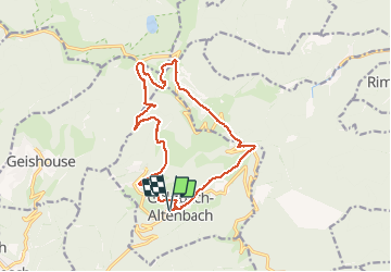
Trail Walking of 14.7 km to be discovered at Grand Est, Haut-Rhin, Goldbach-Altenbach. This trail is proposed by margotte.

Description

Une visite de Goldbach s'impose au départ ou retour de la randonnée.  Panorama à 360° depuis le sommet

Elevation profile

Photos

Positioning

Country:
France
Region :
Grand Est
Department/Province :
Haut-Rhin
Municipality :
Goldbach-Altenbach
Location:
Unknown
Start:(UTM)
358019 ; 5303929 (32T) N.

Trails nearby

Trail Walking Soultz-Haut-Rhin - Hartmannswillerkopf - Circuit découverte - Photo
Walking
VacheKiri67

Walking

Easy
(1)
Soultz-Haut-Rhin, Grand Est, Haut-Rhin, France
3.6 km | 5.2 km-effort
1h 46min
Yes
Trail Walking Soultz-Haut-Rhin - Hartmannswillerkopf - Circuit anneau bleu - Photo
Walking
VacheKiri67

Walking

Medium
(1)
Soultz-Haut-Rhin, Grand Est, Haut-Rhin, France
3.7 km | 5.9 km-effort
1h 37min
Yes
Trail Other activity Steinbach - lac du ballon - Photo
Other activity
rodabruna

Other activity

Very easy
(1)
Steinbach, Grand Est, Haut-Rhin, France
33 km | 64 km-effort
5h 1min
No
Trail On foot Goldbach-Altenbach - Firstacker - Willer sur Thur - Photo
On foot
PRO

On foot

Easy
Goldbach-Altenbach, Grand Est, Haut-Rhin, France
7.4 km | 9.6 km-effort
2h 11min
No
Trail Trail Wattwiller - The History Ultra - stage 1 - Photo
Trail
Olivier Houette

Trail

Very easy
(1)
Wattwiller, Grand Est, Haut-Rhin, France
28 km | 48 km-effort
Unknown
No
Trail On foot Bitschwiller-lès-Thann - Bitschwiller les Thann - Rehbrunnel - Abri du Becherkopf - Roche Albert - Photo
On foot
patrickbeyrath

On foot

Medium
(1)
Bitschwiller-lès-Thann, Grand Est, Haut-Rhin, France
10.3 km | 16.4 km-effort
Unknown
Yes
Trail Walking Soultz-Haut-Rhin - Rando Marcheurs..04/04_2025 - Photo
Walking
boubou68

Walking

Very difficult
Soultz-Haut-Rhin, Grand Est, Haut-Rhin, France
21 km | 35 km-effort
4h 42min
Yes
Trail Walking Soultz-Haut-Rhin - Mon tour des Vosges (4 jours) - Photo
Walking
annefrance70

Walking

Very difficult
Soultz-Haut-Rhin, Grand Est, Haut-Rhin, France
71 km | 113 km-effort
25h 38min
Yes
Trail Walking Moosch - Moosch Haag - Photo
Walking
Estelle Handschin

Walking

Difficult
(1)
Moosch, Grand Est, Haut-Rhin, France
21 km | 0 m-effort
5h 27min
Yes


Close
My subscriptions