Trail Trail Wattwiller - The History Ultra - stage 1 - Photo

The History Ultra - stage 1

© OpenStreetMap contributors
Length
Length
28 km
Max alt
Max alt
1186 m
Uphill gradient
Uphill gradient
1452 m
Km-Effort
Km-Effort  
48 km
Min alt
Min alt
354 m
Downhill gradient
Downhill gradient
1514 m
Boucle
Boucle
No
Creation date :
2021-04-24 11:50:27.28
Updated on :
2021-04-24 11:55:57.056

(1 Reviews)

Trail
Trail
--
Difficulty : Very easy

Scan this QR Code to open this trail in the SityTrail application

FREE GPS app for hiking

Logo SityTrail SityTrail

IGN / Geographical institutes

Download SityTrail from the App Store Download SityTrail from Google Play

Logo SityTrail SityTrail World

The world is yours!

Download SityTrail from the App Store Download SityTrail from Google Play Download SityTrail on Huawei AppGallery

About

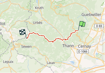
Trail Trail of 28 km to be discovered at Grand Est, Haut-Rhin, Wattwiller. This trail is proposed by Olivier Houette.

Description

The History Ultra - stage 1
Departure: HWK (Historial parking)
Arrival: Ferme auberge du Neuweiher
Updated by Olivier Houette, 24 April 2021

Elevation profile

Positioning

Country:
France
Region :
Grand Est
Department/Province :
Haut-Rhin
Municipality :
Wattwiller
Location:
Unknown
Start:(UTM)
361519 ; 5302141 (32T) N.

Comments

Please log in to post a review or rate the element


Trails nearby

Trail Walking Soultz-Haut-Rhin - Hartmannswillerkopf - Circuit découverte - Photo
Walking
VacheKiri67

Walking

Easy
(1)
Soultz-Haut-Rhin, Grand Est, Haut-Rhin, France
3.6 km | 5.2 km-effort
1h 46min
Yes
Trail Walking Soultz-Haut-Rhin - Hartmannswillerkopf - Circuit anneau bleu - Photo
Walking
VacheKiri67

Walking

Medium
(1)
Soultz-Haut-Rhin, Grand Est, Haut-Rhin, France
3.7 km | 5.9 km-effort
1h 37min
Yes
Trail Other activity Steinbach - lac du ballon - Photo
Other activity
rodabruna

Other activity

Very easy
(1)
Steinbach, Grand Est, Haut-Rhin, France
33 km | 64 km-effort
5h 1min
No
Trail On foot Goldbach-Altenbach - Firstacker - Willer sur Thur - Photo
On foot
PRO

On foot

Easy
Goldbach-Altenbach, Grand Est, Haut-Rhin, France
7.4 km | 9.6 km-effort
2h 11min
No
Trail Walking Thann - SityTrail - 2489713 - thann-roche--albert--grumbachkopf - Photo
Walking
argonneuweg

Walking

Medium
(1)
Thann, Grand Est, Haut-Rhin, France
7.6 km | 12 km-effort
2h 28min
Yes
Trail On foot Bitschwiller-lès-Thann - Bitschwiller les Thann - Rehbrunnel - Abri du Becherkopf - Roche Albert - Photo
On foot
patrickbeyrath

On foot

Medium
(1)
Bitschwiller-lès-Thann, Grand Est, Haut-Rhin, France
10.3 km | 16.4 km-effort
Unknown
Yes
Trail Walking Uffholtz - Molkenrain 1 - Photo
Walking
regisbodilis

Walking

Difficult
(1)
Uffholtz, Grand Est, Haut-Rhin, France
15.4 km | 26 km-effort
4h 0min
Yes
Trail Walking Jungholtz - Rando Retrouvailles...01/03/2024.par Jean Marc - Photo
Walking
boubou68

Walking

Very difficult
Jungholtz, Grand Est, Haut-Rhin, France
11.3 km | 19.2 km-effort
1h 35min
Yes
Trail Walking Steinbach - Rando CLAS du 02/11/2023 - Photo
Walking
boubou68

Walking

Very difficult
Steinbach, Grand Est, Haut-Rhin, France
17.7 km | 27 km-effort
4h 35min
Yes


Close
My subscriptions