Trail Walking Charroux - Le Moulin Parraud  - Photo
 Gegetop
Gegetop

User

© OpenStreetMap contributors
Length
Length
13 km
Max alt
Max alt
422 m
Uphill gradient
Uphill gradient
266 m
Km-Effort
Km-Effort  
16.5 km
Min alt
Min alt
278 m
Downhill gradient
Downhill gradient
266 m
Boucle
Boucle
Yes
Creation date :
2020-10-19 09:51:06.392
Updated on :
2020-10-19 13:37:03.502

(0 Reviews)

Walking
Walking
3h30
Difficulty : Easy
Nordic walking
Nordic walking
3h07
Difficulty : Easy

Scan this QR Code to open this trail in the SityTrail application

FREE GPS app for hiking

Logo SityTrail SityTrail

IGN / Geographical institutes

Download SityTrail from the App Store Download SityTrail from Google Play

Logo SityTrail SityTrail World

The world is yours!

Download SityTrail from the App Store Download SityTrail from Google Play Download SityTrail on Huawei AppGallery

About

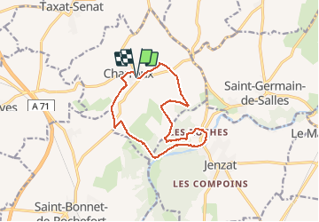
Trail Walking of 13 km to be discovered at Auvergne-Rhône-Alpes, Allier, Charroux. This trail is proposed by Gegetop.

Description

PR. 12
Balade agréable à travers tantôt la Limagne tantôt la forêt de chênes tantôt les Rives de la Sioule.

Elevation profile

Photos

Positioning

Country:
France
Region :
Auvergne-Rhône-Alpes
Department/Province :
Allier
Municipality :
Charroux
Location:
Unknown
Start:(UTM)
512637 ; 5114444 (31T) N.

Trails nearby

Trail Walking Saint-Germain-de-Salles - Les écluses - Photo
Walking
Gegetop

Walking

Easy
Saint-Germain-de-Salles, Auvergne-Rhône-Alpes, Allier, France
12.4 km | 13.5 km-effort
2h 57min
Yes
Trail Walking Charroux - Moulin de Parrot - Photo
Walking
Vincent Bicard

Walking

Medium
Charroux, Auvergne-Rhône-Alpes, Allier, France
14 km | 17.7 km-effort
3h 22min
Yes
Trail Walking Saint-Bonnet-de-Rochefort - les tressots - Photo
Walking
patrickboisard

Walking

Medium
Saint-Bonnet-de-Rochefort, Auvergne-Rhône-Alpes, Allier, France
6.6 km | 8.6 km-effort
1h 37min
Yes
Trail Walking Charroux - Randonnée à Charroux, Vichy, 2023 - Photo
Walking
ezola

Walking

Difficult
Charroux, Auvergne-Rhône-Alpes, Allier, France
13.2 km | 16.7 km-effort
3h 22min
No
Trail Walking Saint-Bonnet-de-Rochefort - Randonnée organisée  - Photo
Walking
Vincent Bicard

Walking

Medium
Saint-Bonnet-de-Rochefort, Auvergne-Rhône-Alpes, Allier, France
6.1 km | 7 km-effort
1h 40min
Yes
Trail Walking Charroux - GR de Pays Val de Sioule - Photo
Walking
loursblanc

Walking

Easy
Charroux, Auvergne-Rhône-Alpes, Allier, France
77 km | 100 km-effort
20h 0min
Yes
Trail Walking Charroux - GR de Pays Val de Sioule - Photo
Walking
loursblanc

Walking

Easy
Charroux, Auvergne-Rhône-Alpes, Allier, France
77 km | 100 km-effort
20h 0min
Yes
Trail Other activity Charroux - charroux  - Photo
Other activity
kronio

Other activity

Easy
Charroux, Auvergne-Rhône-Alpes, Allier, France
9.1 km | 13 km-effort
3h 21min
Yes
Trail Walking Charroux - charroux 2 em marche  - Photo
Walking
jjf

Walking

Very easy
Charroux, Auvergne-Rhône-Alpes, Allier, France
5.9 km | 7.4 km-effort
1h 9min
Yes


Close
My subscriptions