Trail Walking Saint-Rabier - Gd Coderc Grange d'Ans 12 km - Photo

Gd Coderc Grange d'Ans 12 km

 YV24
YV24

User

© OpenStreetMap contributors
Length
Length
11.7 km
Max alt
Max alt
313 m
Uphill gradient
Uphill gradient
285 m
Km-Effort
Km-Effort  
15.5 km
Min alt
Min alt
195 m
Downhill gradient
Downhill gradient
285 m
Boucle
Boucle
Yes
Creation date :
2018-02-19 00:00:00.0
Updated on :
2018-02-19 00:00:00.0

(0 Reviews)

Walking
Walking
3h18
Difficulty : Easy

Scan this QR Code to open this trail in the SityTrail application

FREE GPS app for hiking

Logo SityTrail SityTrail

IGN / Geographical institutes

Download SityTrail from the App Store Download SityTrail from Google Play

Logo SityTrail SityTrail World

The world is yours!

Download SityTrail from the App Store Download SityTrail from Google Play Download SityTrail on Huawei AppGallery

About

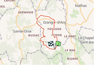
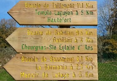
Trail Walking of 11.7 km to be discovered at New Aquitaine, Dordogne, Saint-Rabier. This trail is proposed by YV24.

Description

Boucle de Grange d'Ans Sud étendue.

Elevation profile

Positioning

Country:
France
Region :
New Aquitaine
Department/Province :
Dordogne
Municipality :
Saint-Rabier
Location:
Unknown
Start:(UTM)
352198 ; 5005314 (31T) N.

Trails nearby

Trail Walking Sainte-Orse - Boucle Taille petit variante  - Photo
Walking
NICOLEROBERT

Walking

Medium
Sainte-Orse, New Aquitaine, Dordogne, France
12 km | 15.3 km-effort
3h 5min
Yes
Trail Walking Nailhac - Boucle de Nailhac  - Photo
Walking
swp648

Walking

Easy
Nailhac, New Aquitaine, Dordogne, France
11.7 km | 14.9 km-effort
2h 54min
Yes
Trail Mountain bike Sainte-Orse - De Sainte Orse au Verdoyant - Photo
Mountain bike
tracegps

Mountain bike

Difficult
Sainte-Orse, New Aquitaine, Dordogne, France
32 km | 40 km-effort
3h 0min
No
Trail Walking Granges-d'Ans - Paysage et nature depuis Granges-d’Ans - Photo
Walking
houbart

Walking

Difficult
Granges-d'Ans, New Aquitaine, Dordogne, France
11.8 km | 15 km-effort
3h 24min
Yes
Trail Walking La Bachellerie - Boucle de la Bachellerie - Photo
Walking
CC.RIDER

Walking

Difficult
La Bachellerie, New Aquitaine, Dordogne, France
11.9 km | 15.8 km-effort
3h 35min
Yes
Trail Mountain bike La Chapelle-Saint-Jean - La Chapelle Saint Jean - Photo
Mountain bike
heyoka

Mountain bike

Easy
La Chapelle-Saint-Jean, New Aquitaine, Dordogne, France
11.7 km | 14.7 km-effort
3h 20min
No
Trail Walking Sainte-Orse - Ste Orse Taillepetit 13km - Photo
Walking
YV24

Walking

Easy
Sainte-Orse, New Aquitaine, Dordogne, France
12.1 km | 15.2 km-effort
3h 20min
Yes
Trail Walking Sainte-Orse - St Orse Boucle de Gabillou - Photo
Walking
swp648

Walking

Easy
Sainte-Orse, New Aquitaine, Dordogne, France
11.1 km | 13.4 km-effort
2h 38min
Yes
Trail Mountain bike Thenon - Sortie Thenon - Photo
Mountain bike
guycouderc

Mountain bike

Medium
Thenon, New Aquitaine, Dordogne, France
25 km | 30 km-effort
1h 59min
Yes


Close
My subscriptions