Trail Walking Pontorson - GR 34 Etape 1 Pontorson Palluel Saint Marcan 12-10-2020 - Photo

GR 34 Etape 1 Pontorson Palluel Saint Marcan 12-10-2020

 Kargil
Kargil

User GUIDE

© OpenStreetMap contributors
Length
Length
27 km
Max alt
Max alt
82 m
Uphill gradient
Uphill gradient
191 m
Km-Effort
Km-Effort  
29 km
Min alt
Min alt
2 m
Downhill gradient
Downhill gradient
188 m
Boucle
Boucle
No
Creation date :
2020-10-24 15:09:27.606
Updated on :
2020-10-24 15:43:11.011

(0 Reviews)

Walking
Walking
6h29
Difficulty : Medium

Scan this QR Code to open this trail in the SityTrail application

FREE GPS app for hiking

Logo SityTrail SityTrail

IGN / Geographical institutes

Download SityTrail from the App Store Download SityTrail from Google Play

Logo SityTrail SityTrail World

The world is yours!

Download SityTrail from the App Store Download SityTrail from Google Play Download SityTrail on Huawei AppGallery

About

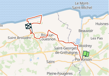
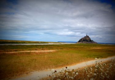
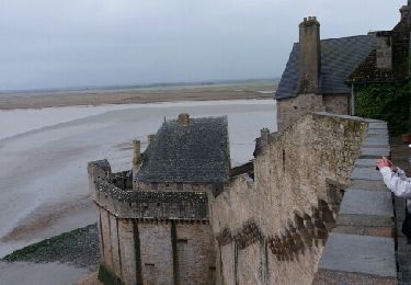
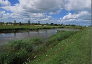
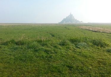
Trail Walking of 27 km to be discovered at Normandy, Manche, Pontorson. This trail is proposed by Kargil.

Description

Etape de 16 km jusqu'au gîte avec 11 km de bonus sans sac.

Elevation profile

Points of interest

Point of interest Saint-Marcan - Gîte Les Fleurettes - Photo
Kargil
SAINT-MARCAN 

Positioning

Country:
France
Region :
Normandy
Department/Province :
Manche
Municipality :
Pontorson
Location:
Pontorson
Start:(UTM)
609752 ; 5378853 (30U) N.

Trails nearby

Trail On foot Saint-Georges-de-Gréhaigne - Circuit du Petit Bois & de la Grève - Photo
On foot
PRO

On foot

Easy
Saint-Georges-de-Gréhaigne, Brittany, Ille-et-Vilaine, France
9.1 km | 10.4 km-effort
2h 21min
Yes
Trail Mountain bike Beauvoir - SityTrail - 2506836 - beauvoir_20200724_092923 - Photo
Mountain bike
GUIDE
pascalou73

Mountain bike

Medium
Beauvoir, Normandy, Manche, France
29 km | 32 km-effort
Unknown
Yes
Trail Walking Pleine-Fougères - GR_37_AB_16_Pleine-Fougeres_Val-Couesnon_20210522 - Photo
Walking
patrickdanilo

Walking

Easy
Pleine-Fougères, Brittany, Ille-et-Vilaine, France
16.6 km | 19.4 km-effort
3h 45min
No
Trail Walking Pontorson - Les bords du Couesnon - Photo
Walking
cecillon

Walking

Very easy
Pontorson, Normandy, Manche, France
10 km | 10.6 km-effort
2h 7min
Yes
Trail Walking Pontorson - sentier roman pontorson - Mont Saint Michel - Photo
Walking
MoulinPierrick

Walking

Easy
Pontorson, Normandy, Manche, France
11.4 km | 12.4 km-effort
2h 44min
No
Trail Walking Pontorson - pontorson - Mont Saint Michel - Photo
Walking
MoulinPierrick

Walking

Easy
Pontorson, Normandy, Manche, France
11.4 km | 12.4 km-effort
2h 24min
No
Trail Mountain bike Pontorson - De Pontorson à la chapelle Sainte-Anne - Photo
Mountain bike
tracegps

Mountain bike

Medium
Pontorson, Normandy, Manche, France
32 km | 33 km-effort
3h 0min
Yes
Trail Walking Pontorson - GR34 étape 6 - Photo
Walking
lagardienne

Walking

Easy
Pontorson, Normandy, Manche, France
23 km | 25 km-effort
5h 30min
No
Trail Mountain bike Pontorson - Randonnée de Pontorson au Mont Saint Michel - Photo
Mountain bike
tracegps

Mountain bike

Medium
Pontorson, Normandy, Manche, France
20 km | 22 km-effort
2h 30min
Yes


Close
My subscriptions