Trail Horseback riding Molsheim - SityTrail - Boucle Avolsheim Soultz-Les-Bains - Photo

SityTrail - Boucle Avolsheim Soultz-Les-Bains

Promouvoir le Tourisme Equestre en Alsace GUIDE+

© OpenStreetMap contributors
Length
Length
18.3 km
Max alt
Max alt
358 m
Uphill gradient
Uphill gradient
416 m
Km-Effort
Km-Effort  
24 km
Min alt
Min alt
165 m
Downhill gradient
Downhill gradient
416 m
Boucle
Boucle
Yes
Creation date :
2020-10-29 16:34:13.357
Updated on :
2021-03-19 14:35:32.77

(0 Reviews)

Horseback riding
Horseback riding
2h57
Difficulty : Medium

Scan this QR Code to open this trail in the SityTrail application

FREE GPS app for hiking

Logo SityTrail SityTrail

IGN / Geographical institutes

Download SityTrail from the App Store Download SityTrail from Google Play

Logo SityTrail SityTrail World

The world is yours!

Download SityTrail from the App Store Download SityTrail from Google Play Download SityTrail on Huawei AppGallery

About

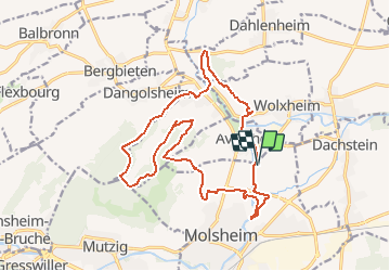
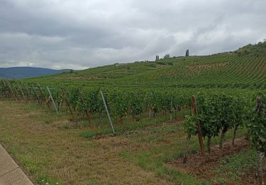
Trail Horseback riding of 18.3 km to be discovered at Grand Est, Bas-Rhin, Molsheim. This trail is proposed by Tourisme Equestre Alsace.

Description

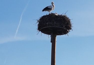
Balade au départ de la chapelle du Dompeter à Avolsheim, avec passage aux haltes équestre du Kaltbrunn et du Holtzbrunnen, disposant tous 2 de fontaines et tables de pique-nique. Possibilité de se baigner dans la Bruche.

Elevation profile

Photos

Points of interest

Point of interest Soultz-les-Bains - Halte équestre du Holtzbrunnen - Photo
holtzv

Positioning

Country:
France
Region :
Grand Est
Department/Province :
Bas-Rhin
Municipality :
Molsheim
Location:
Unknown
Start:(UTM)
389640 ; 5379244 (32U) N.

Trails nearby

Trail Walking Mutzig - Les sanctuaires autour de Mutzig - Photo
Walking
VacheKiri67

Walking

Medium
(1)
Mutzig, Grand Est, Bas-Rhin, France
13.6 km | 17.9 km-effort
5h 0min
Yes
Trail Walking Wolxheim - wolxheim, chapelle st-denis. - Photo
Walking
jo-da

Walking

Medium
(1)
Wolxheim, Grand Est, Bas-Rhin, France
6.9 km | 8.3 km-effort
2h 19min
Yes
Trail Walking Mutzig - Les sanctuaires autour de Mutzig - Photo
Walking
tracegps

Walking

Difficult
(1)
Mutzig, Grand Est, Bas-Rhin, France
12.7 km | 16.8 km-effort
4h 0min
Yes
Trail Walking Dorlisheim - Escapade dans le vignoble de Dorlisheim - Photo
Walking
tracegps

Walking

Medium
(1)
Dorlisheim, Grand Est, Bas-Rhin, France
9.7 km | 12.6 km-effort
3h 0min
Yes
Trail Walking Mutzig - Autour du Fort de Mutzig - Photo
Walking
VacheKiri67

Walking

Difficult
(2)
Mutzig, Grand Est, Bas-Rhin, France
18.7 km | 26 km-effort
6h 30min
Yes
Trail Walking Molsheim - Les Chapelles entre vignoble et canal - Photo
Walking
VacheKiri67

Walking

Medium
(2)
Molsheim, Grand Est, Bas-Rhin, France
14.8 km | 17 km-effort
3h 43min
Yes
Trail Nordic walking Bergbieten - Bergbieten 20240307 - Photo
Nordic walking
Michel 67170

Nordic walking

Very easy
Bergbieten, Grand Est, Bas-Rhin, France
11.3 km | 15.3 km-effort
2h 42min
Yes
Trail Road bike Molsheim - Molsheim - Turckheim  - Photo
Road bike
apa

Road bike

Medium
Molsheim, Grand Est, Bas-Rhin, France
78 km | 88 km-effort
5h 3min
No
Trail Walking Molsheim - Molsheim - les bords de la Bruche - Dompeter - Photo
Walking
Bart2015

Walking

Easy
Molsheim, Grand Est, Bas-Rhin, France
11.5 km | 12.3 km-effort
2h 18min
Yes


Close
My subscriptions