Trail Walking Molsheim - Molsheim - les bords de la Bruche - Dompeter - Photo

Molsheim - les bords de la Bruche - Dompeter

 Bart2015
Bart2015

User

© OpenStreetMap contributors
Length
Length
11.5 km
Max alt
Max alt
177 m
Uphill gradient
Uphill gradient
60 m
Km-Effort
Km-Effort  
12.3 km
Min alt
Min alt
160 m
Downhill gradient
Downhill gradient
61 m
Boucle
Boucle
Yes
Creation date :
2023-02-12 10:02:03.313
Updated on :
2023-02-13 11:47:29.264

(0 Reviews)

Walking
Walking
2h18
Difficulty : Easy

Scan this QR Code to open this trail in the SityTrail application

FREE GPS app for hiking

Logo SityTrail SityTrail

IGN / Geographical institutes

Download SityTrail from the App Store Download SityTrail from Google Play

Logo SityTrail SityTrail World

The world is yours!

Download SityTrail from the App Store Download SityTrail from Google Play Download SityTrail on Huawei AppGallery

About

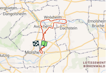
Trail Walking of 11.5 km to be discovered at Grand Est, Bas-Rhin, Molsheim. This trail is proposed by Bart2015.

Description

Randonnée sympa en bordure de la Bruche mêlant voie cyclable et sentiers. Une petite halte à Dompeter s'impose ... Il est fort probable de rencontrer des cigognes, des hérons ou des martins pêcheurs ...
Attention les sentiers risquent d'être boueux en période de pluie.
Bonne balade ...

Elevation profile

Photos

Positioning

Country:
France
Region :
Grand Est
Department/Province :
Bas-Rhin
Municipality :
Molsheim
Location:
Unknown
Start:(UTM)
389182 ; 5377811 (32U) N.

Trails nearby

Trail Walking Mutzig - Les sanctuaires autour de Mutzig - Photo
Walking
VacheKiri67

Walking

Medium
(1)
Mutzig, Grand Est, Bas-Rhin, France
13.6 km | 17.9 km-effort
5h 0min
Yes
Trail Walking Wolxheim - wolxheim, chapelle st-denis. - Photo
Walking
jo-da

Walking

Medium
(1)
Wolxheim, Grand Est, Bas-Rhin, France
6.9 km | 8.3 km-effort
2h 19min
Yes
Trail Walking Mutzig - Les sanctuaires autour de Mutzig - Photo
Walking
tracegps

Walking

Difficult
(1)
Mutzig, Grand Est, Bas-Rhin, France
12.7 km | 16.8 km-effort
4h 0min
Yes
Trail Walking Dorlisheim - Escapade dans le vignoble de Dorlisheim - Photo
Walking
tracegps

Walking

Medium
(1)
Dorlisheim, Grand Est, Bas-Rhin, France
9.7 km | 12.6 km-effort
3h 0min
Yes
Trail Walking Mutzig - Autour du Fort de Mutzig - Photo
Walking
VacheKiri67

Walking

Difficult
(2)
Mutzig, Grand Est, Bas-Rhin, France
18.7 km | 26 km-effort
6h 30min
Yes
Trail Walking Molsheim - Les Chapelles entre vignoble et canal - Photo
Walking
VacheKiri67

Walking

Medium
(2)
Molsheim, Grand Est, Bas-Rhin, France
14.8 km | 17 km-effort
3h 43min
Yes
Trail On foot Rosheim - Circuit du Vignoble - Photo
On foot
PRO

On foot

Easy
Rosheim, Grand Est, Bas-Rhin, France
8.8 km | 11.7 km-effort
2h 38min
Yes
Trail Mountain bike Rosheim - schnacker tour le grand 8 circuit magique - Photo
Mountain bike
raphnou

Mountain bike

Difficult
(1)
Rosheim, Grand Est, Bas-Rhin, France
29 km | 39 km-effort
2h 30min
Yes
Trail Walking Rosenwiller - 2015-05-17 Marche Gourmande Rosenwiller - Photo
Walking
GUIDE
holtzv

Walking

Easy
(1)
Rosenwiller, Grand Est, Bas-Rhin, France
8.8 km | 11 km-effort
2h 23min
No


Close
My subscriptions