Trail Walking Azerat - Azérat  Douime - Photo
 YV24
YV24

User

© OpenStreetMap contributors
Length
Length
12.4 km
Max alt
Max alt
294 m
Uphill gradient
Uphill gradient
217 m
Km-Effort
Km-Effort  
15.3 km
Min alt
Min alt
131 m
Downhill gradient
Downhill gradient
220 m
Boucle
Boucle
Yes
Creation date :
2014-12-10 00:00:00.0
Updated on :
2014-12-10 00:00:00.0

(1 Reviews)

Walking
Walking
3h17
Difficulty : Easy

Scan this QR Code to open this trail in the SityTrail application

FREE GPS app for hiking

Logo SityTrail SityTrail

IGN / Geographical institutes

Download SityTrail from the App Store Download SityTrail from Google Play

Logo SityTrail SityTrail World

The world is yours!

Download SityTrail from the App Store Download SityTrail from Google Play Download SityTrail on Huawei AppGallery

About

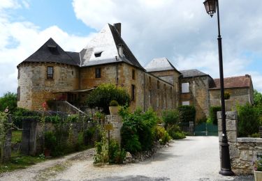
Trail Walking of 12.4 km to be discovered at New Aquitaine, Dordogne, Azerat. This trail is proposed by YV24.

Description

PDIPR Azérat Boucle du Douime.
Dépar parking au dessus de la mairie.
Tracé sympa, varié, vallonné,  bien balisé et panneauté. Plusieurs jolis hameaux sur le parcours.

Elevation profile

Positioning

Country:
France
Region :
New Aquitaine
Department/Province :
Dordogne
Municipality :
Azerat
Location:
Unknown
Start:(UTM)
352599 ; 5001281 (31T) N.

Comments

Please log in to post a review or rate the element


Trails nearby

Trail Mountain bike Thenon - Du Verdoyant à Saint Léon-sur-Vézère - Photo
Mountain bike
tracegps

Mountain bike

Difficult
Thenon, New Aquitaine, Dordogne, France
30 km | 40 km-effort
3h 0min
No
Trail Mountain bike Thenon - Du Verdoyant à St Orse avec la boucle du Boscornut -  Thenon - Photo
Mountain bike
tracegps

Mountain bike

Difficult
Thenon, New Aquitaine, Dordogne, France
35 km | 46 km-effort
3h 0min
No
Trail Walking La Bachellerie - Boucle de la Bachellerie - Photo
Walking
CC.RIDER

Walking

Difficult
La Bachellerie, New Aquitaine, Dordogne, France
11.9 km | 15.8 km-effort
3h 35min
Yes
Trail Mountain bike Thenon - Au départ du Verdoyant - Thenon - Photo
Mountain bike
tracegps

Mountain bike

Difficult
Thenon, New Aquitaine, Dordogne, France
34 km | 45 km-effort
3h 0min
Yes
Trail Mountain bike La Chapelle-Saint-Jean - 2 - Photo
Mountain bike
christophe binet

Mountain bike

Very difficult
La Chapelle-Saint-Jean, New Aquitaine, Dordogne, France
41 km | 52 km-effort
1h 47min
No
Trail Walking La Bachellerie - la bachellerie (24) azeirat st rabier - Photo
Walking
miremi

Walking

Difficult
La Bachellerie, New Aquitaine, Dordogne, France
12.3 km | 16.3 km-effort
3h 28min
Yes
Trail Walking Saint-Rabier - chateau coderc - Photo
Walking
personono

Walking

Easy
Saint-Rabier, New Aquitaine, Dordogne, France
7.1 km | 9 km-effort
1h 52min
Yes
Trail Walking Auriac-du-Périgord - Auriac Azérat 16km - Photo
Walking
YV24

Walking

Easy
Auriac-du-Périgord, New Aquitaine, Dordogne, France
15.3 km | 21 km-effort
4h 11min
Yes
Trail Walking Saint-Rabier - Gd Coderc Grange d'Ans 12 km - Photo
Walking
YV24

Walking

Easy
Saint-Rabier, New Aquitaine, Dordogne, France
11.7 km | 15.5 km-effort
3h 18min
Yes


Close
My subscriptions