Trail Walking Lay-Saint-Remy - circuit des tunnels - Photo
 mannequ1
mannequ1

User

© OpenStreetMap contributors
Length
Length
16.6 km
Max alt
Max alt
382 m
Uphill gradient
Uphill gradient
383 m
Km-Effort
Km-Effort  
22 km
Min alt
Min alt
244 m
Downhill gradient
Downhill gradient
381 m
Boucle
Boucle
Yes
Creation date :
2014-12-10 00:00:00.0
Updated on :
2014-12-10 00:00:00.0

(0 Reviews)

Walking
Walking
4h39
Difficulty : Medium

Scan this QR Code to open this trail in the SityTrail application

FREE GPS app for hiking

Logo SityTrail SityTrail

IGN / Geographical institutes

Download SityTrail from the App Store Download SityTrail from Google Play

Logo SityTrail SityTrail World

The world is yours!

Download SityTrail from the App Store Download SityTrail from Google Play Download SityTrail on Huawei AppGallery

About

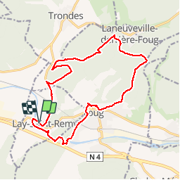
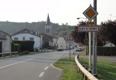
Trail Walking of 16.6 km to be discovered at Grand Est, Meurthe-et-Moselle, Lay-Saint-Remy. This trail is proposed by mannequ1.

Description

circuit proposé par l'association sentiers de la linotte

Elevation profile

Positioning

Country:
France
Region :
Grand Est
Department/Province :
Meurthe-et-Moselle
Municipality :
Lay-Saint-Remy
Location:
Unknown
Start:(UTM)
703156 ; 5395714 (31U) N.

Trails nearby

Trail On foot Laneuveville-derrière-Foug - Circuit de Domfontaine - Photo
On foot
PRO

On foot

Easy
Laneuveville-derrière-Foug, Grand Est, Meurthe-et-Moselle, France
9.5 km | 12.6 km-effort
2h 51min
Yes
Trail On foot Trondes - Circuit du Romont - Photo
On foot
PRO

On foot

Easy
Trondes, Grand Est, Meurthe-et-Moselle, France
6.8 km | 8.1 km-effort
1h 50min
Yes
Trail On foot Foug - Circuit de Grammont - Photo
On foot
PRO

On foot

Easy
Foug, Grand Est, Meurthe-et-Moselle, France
15.6 km | 19.3 km-effort
4h 23min
No
Trail On foot Choloy-Ménillot - Boucle des Sources - Photo
On foot
PRO

On foot

Easy
Choloy-Ménillot, Grand Est, Meurthe-et-Moselle, France
10.4 km | 11.9 km-effort
2h 42min
No
Trail On foot Lay-Saint-Remy - Circuit des Tunnels - Photo
On foot
PRO

On foot

Easy
Lay-Saint-Remy, Grand Est, Meurthe-et-Moselle, France
11.1 km | 14.2 km-effort
3h 14min
No
Trail On foot Laneuveville-derrière-Foug - Circuit du Point du Jour - Photo
On foot
PRO

On foot

Easy
Laneuveville-derrière-Foug, Grand Est, Meurthe-et-Moselle, France
6.8 km | 8 km-effort
1h 49min
No
Trail Walking Écrouves - Ecrouves 16 700m +323m - Photo
Walking
DanielROLLET

Walking

Easy
Écrouves, Grand Est, Meurthe-et-Moselle, France
16.8 km | 21 km-effort
5h 41min
Yes
Trail Equestrian Trondes - baignade Troussey - Photo
Equestrian
sandra54570

Equestrian

Medium
Trondes, Grand Est, Meurthe-et-Moselle, France
19.8 km | 25 km-effort
2h 56min
Yes
Trail Walking Choloy-Ménillot - Cholloy-Ménillot 14 150m +335m - Photo
Walking
DanielROLLET

Walking

Difficult
Choloy-Ménillot, Grand Est, Meurthe-et-Moselle, France
14.2 km | 18.6 km-effort
3h 30min
Yes


Close
My subscriptions