Trail Walking Plan-d'Aups-Sainte-Baume - source Huveaune, chemin des rois - Photo
© OpenStreetMap contributors
Length
Length
15.4 km
Max alt
Max alt
706 m
Uphill gradient
Uphill gradient
594 m
Km-Effort
Km-Effort  
23 km
Min alt
Min alt
404 m
Downhill gradient
Downhill gradient
595 m
Boucle
Boucle
Yes
Creation date :
2021-01-26 08:35:21.02
Updated on :
2021-02-01 13:17:04.666

(0 Reviews)

Walking
Walking
6h03
Difficulty : Medium

Scan this QR Code to open this trail in the SityTrail application

FREE GPS app for hiking

Logo SityTrail SityTrail

IGN / Geographical institutes

Download SityTrail from the App Store Download SityTrail from Google Play

Logo SityTrail SityTrail World

The world is yours!

Download SityTrail from the App Store Download SityTrail from Google Play Download SityTrail on Huawei AppGallery

About

Trail Walking of 15.4 km to be discovered at Provence-Alpes-Côte d'Azur, Var, Plan-d'Aups-Sainte-Baume. This trail is proposed by cdanielrando.

Description

Départ du pk de l'hôtellerie . Se diriger vers le nord et suivre le sentier rive droite de l'Huveaune  bien balisé. Arrivé aux sources, traverser pour accéder rive gauche d' où la vue sur les vasques est plus spectaculaire. Si le courant est trop fort, continuer rive droite , rejoindre le gr 9 et le suivre vers la gauche pour récupérer l'itinéraire qui monte vers nans les pins.
Des ruines du château, un aller retour à la croix  pour bénéficier d'un point de vue magnifique, sur un paysage qui va jusqu'aux Alpes vaut vraiment l'effort. La remontée par le  chemin des rois et ses calvaires termine bien ce circuit  magnifique.

Elevation profile

Photos

Positioning

Country:
France
Region :
Provence-Alpes-Côte d'Azur
Department/Province :
Var
Municipality :
Plan-d'Aups-Sainte-Baume
Location:
Unknown
Start:(UTM)
723426 ; 4801827 (31T) N.

Trails nearby

Trail Walking Plan-d'Aups-Sainte-Baume - Sainte Baume 8,5 km - Photo
Walking
GUIDE
rvapeldo

Walking

Medium
(1)
Plan-d'Aups-Sainte-Baume, Provence-Alpes-Côte d'Azur, Var, France
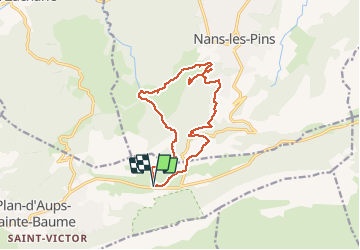
8.4 km | 15.5 km-effort
4h 38min
Yes
Trail Walking Nans-les-Pins - Le baou des glacières - Photo
Walking
GUIDE
amiral13

Walking

Medium
(1)
Nans-les-Pins, Provence-Alpes-Côte d'Azur, Var, France
7.6 km | 12.2 km-effort
4h 27min
Yes
Trail Walking Plan-d'Aups-Sainte-Baume - SityTrail - Sentier merveilleux - La Ste baume - Le Plan d'aups  - Photo
Walking
GUIDE
affinetataille

Walking

Medium
(1)
Plan-d'Aups-Sainte-Baume, Provence-Alpes-Côte d'Azur, Var, France
15 km | 23 km-effort
6h 0min
Yes
Trail Walking Plan-d'Aups-Sainte-Baume - Crêts de la Ste Baume - Photo
Walking
tracegps

Walking

Medium
(2)
Plan-d'Aups-Sainte-Baume, Provence-Alpes-Côte d'Azur, Var, France
15.4 km | 23 km-effort
5h 0min
Yes
Trail Walking Nans-les-Pins - La Croix des Glacières, Sainte-Baume - Photo
Walking
tracegps

Walking

Medium
(1)
Nans-les-Pins, Provence-Alpes-Côte d'Azur, Var, France
7.2 km | 12 km-effort
3h 19min
Yes
Trail Walking Plan-d'Aups-Sainte-Baume - Du Col du Saint-Pilon au Pas de l'Aï, Sainte Baume - Photo
Walking
tracegps

Walking

Medium
(1)
Plan-d'Aups-Sainte-Baume, Provence-Alpes-Côte d'Azur, Var, France
13.1 km | 20 km-effort
5h 15min
Yes
Trail Walking Riboux - Riboux - Forêt de Malaucène - Photo
Walking
tracegps

Walking

Medium
(4)
Riboux, Provence-Alpes-Côte d'Azur, Var, France
12.2 km | 15.2 km-effort
2h 40min
Yes
Trail Walking Plan-d'Aups-Sainte-Baume - La Grotte aux oiseaux - Plan d'Aups  - Photo
Walking
tracegps

Walking

Medium
(1)
Plan-d'Aups-Sainte-Baume, Provence-Alpes-Côte d'Azur, Var, France
8.8 km | 12.5 km-effort
2h 30min
Yes
Trail On foot Plan-d'Aups-Sainte-Baume - Massif Sainte Baume et pas de l’Aï 15 km - Photo
On foot
GUIDE
rvapeldo

On foot

Medium
Plan-d'Aups-Sainte-Baume, Provence-Alpes-Côte d'Azur, Var, France
15 km | 22 km-effort
5h 0min
Yes


Close
My subscriptions