Trail Walking Montregard - Vallée de la St bonette - Photo
 phcol
phcol

User

© OpenStreetMap contributors
Length
Length
11.2 km
Max alt
Max alt
1074 m
Uphill gradient
Uphill gradient
413 m
Km-Effort
Km-Effort  
16.7 km
Min alt
Min alt
870 m
Downhill gradient
Downhill gradient
415 m
Boucle
Boucle
Yes
Creation date :
2021-02-10 16:55:06.118
Updated on :
2021-02-10 17:01:44.745

(0 Reviews)

Walking
Walking
3h48
Difficulty : Difficult

Scan this QR Code to open this trail in the SityTrail application

FREE GPS app for hiking

Logo SityTrail SityTrail

IGN / Geographical institutes

Download SityTrail from the App Store Download SityTrail from Google Play

Logo SityTrail SityTrail World

The world is yours!

Download SityTrail from the App Store Download SityTrail from Google Play Download SityTrail on Huawei AppGallery

About

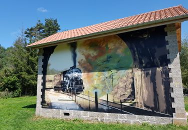
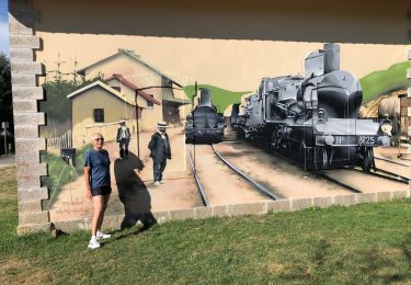
Trail Walking of 11.2 km to be discovered at Auvergne-Rhône-Alpes, Haute-Loire, Montregard. This trail is proposed by phcol.

Description

Boucle qui part juste après l'élevage de cochon de la Raille sur la route de Lérissel et limenesse.

Elevation profile

Positioning

Country:
France
Region :
Auvergne-Rhône-Alpes
Department/Province :
Haute-Loire
Municipality :
Montregard
Location:
Unknown
Start:(UTM)
607042 ; 5004318 (31T) N.

Trails nearby

Trail Mountain bike Montregard - Espace VTT FFC Le Velay des 3 Rivières - N°15 Le Ruisseau de Trifoulou Montregard - Photo
Mountain bike
tracegps

Mountain bike

Medium
(1)
Montregard, Auvergne-Rhône-Alpes, Haute-Loire, France
17.7 km | 23 km-effort
2h 0min
Yes
Trail Walking Montregard - lalyret  - Photo
Walking
poterie

Walking

Difficult
(1)
Montregard, Auvergne-Rhône-Alpes, Haute-Loire, France
10.8 km | 14.6 km-effort
3h 18min
Yes
Trail Walking Montregard - Rando t'est  - Photo
Walking
jroche425@gmail.com

Walking

Easy
(1)
Montregard, Auvergne-Rhône-Alpes, Haute-Loire, France
1.1 km | 1.2 km-effort
19min
Yes
Trail Walking Montfaucon-en-Velay - Jakobsweg 2014-1 - Photo
Walking
martinstalder

Walking

Easy
(2)
Montfaucon-en-Velay, Auvergne-Rhône-Alpes, Haute-Loire, France
18.7 km | 25 km-effort
5h 22min
No
Trail Mountain bike Riotord - Ru de Saint Meyras - Riotord - Photo
Mountain bike
tracegps

Mountain bike

Difficult
Riotord, Auvergne-Rhône-Alpes, Haute-Loire, France
14.8 km | 20 km-effort
1h 30min
Yes
Trail Walking Riotord - Ru de Saint Meyras - Riotord - Photo
Walking
tracegps

Walking

Difficult
Riotord, Auvergne-Rhône-Alpes, Haute-Loire, France
14.8 km | 20 km-effort
4h 0min
Yes
Trail Road bike Riotord - 42 st genest malifaux passerelle lijgnon yssingeaux - Photo
Road bike
himba26100

Road bike

Medium
Riotord, Auvergne-Rhône-Alpes, Haute-Loire, France
90 km | 111 km-effort
5h 48min
No
Trail Mountain bike Dunières - voie verte Duniere Tracol - Photo
Mountain bike
bena42

Mountain bike

Very easy
Dunières, Auvergne-Rhône-Alpes, Haute-Loire, France
21 km | 25 km-effort
3h 48min
Yes
Trail Mountain bike Montfaucon-en-Velay - Via Fluvia de Montfaucon au tunnel de Tracol - Photo
Mountain bike
Pat_83200

Mountain bike

Very easy
Montfaucon-en-Velay, Auvergne-Rhône-Alpes, Haute-Loire, France
33 km | 40 km-effort
2h 41min
Yes


Close
My subscriptions