


PHR TM Day 9

ARVIEU
User
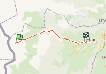

Length
8.4 km

Max alt
1860 m

Uphill gradient
29 m
Km-Effort
12 km

Min alt
894 m

Downhill gradient
984 m
Boucle
No
Creation date :
2021-02-19 06:31:07.715
Updated on :
2021-02-19 06:32:00.416
2h42
Difficulty : Medium

FREE GPS app for hiking
 SityTrail
IGN / Geographical institutes
SityTrail Plus
The world is yours!
About
Trail Walking of 8.4 km to be discovered at New Aquitaine, Pyrénées-Atlantiques, Lescun. This trail is proposed by ARVIEU.
Positioning
Country:
France
Region :
New Aquitaine
Department/Province :
Pyrénées-Atlantiques
Municipality :
Lescun
Location:
Unknown
Start:(Dec)
Start:(UTM)
685896 ; 4755819 (30T) N.
Comments