Lescun, Pyrénées-Atlantiques: Best trails, routes and walks

7 comments

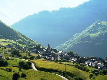
Lescun: Discover the best trails: 115 hiking trails and 1 bike and mountain-bike routes. All these trails, routes and outdoor activities are available in our SityTrail applications for smartphones and tablets.


The best trails (121)

Trail Walking Lescun - Le plateau de Sanchèse - Lescun - Photo
Walking 5.389
Km

Walking

Easy
(1)
Lescun, New Aquitaine, Pyrénées-Atlantiques, France
5.4 km | 7.4 km-effort
2h 0min
153 m
153 m
Yes
tracegps

Trail Walking Lescun - Lac de Lhurs - Photo
Walking 9.454
Km

Walking

Medium
(2)
Lescun, New Aquitaine, Pyrénées-Atlantiques, France
9.5 km | 19.2 km-effort
4h 0min
732 m
731 m
Yes
tracegps

Trail On foot Lescun - Cabanes et Lac de Lhurs asp51 - Photo
On foot 5.865
Km
PRO

On foot

Easy
Lescun, New Aquitaine, Pyrénées-Atlantiques, France
5.9 km | 13.2 km-effort
2h 59min
726 m
16 m
No
SityTrail - itinéraires balisés pédestres

• Trail created by Communauté de Communes du Haut-Béarn. Randonnée difficile 5h10 aller-retour Symbol: bar Website:...

Trail On foot Lescun - Tour du Belvédère asp47 - Photo
On foot 4.442
Km
PRO

On foot

Easy
Lescun, New Aquitaine, Pyrénées-Atlantiques, France
4.4 km | 8.9 km-effort
2h 1min
335 m
325 m
Yes
SityTrail - itinéraires balisés pédestres

• Trail created by Communauté de Communes du Haut-Béarn. Randonnée facile 2h45 semi-boucle Symbol: bar Website: htt...

Trail On foot Lescun - Refuge de Linza par le Col de Pétragème asp119 - Photo
On foot 13.114
Km
PRO

On foot

Medium
Lescun, New Aquitaine, Pyrénées-Atlantiques, France
13.1 km | 27 km-effort
6h 14min
1169 m
797 m
No
SityTrail - itinéraires balisés pédestres

• Trail created by Communauté de Communes du Haut-Béarn / Ayuntamiento de Ansó. Randonnée difficile 6h00 aller simple ...

Trail Walking Lescun - Cirque de Lescun - Photo
Walking 5.543
Km

Walking

Medium
(1)
Lescun, New Aquitaine, Pyrénées-Atlantiques, France
5.5 km | 7.8 km-effort
1h 46min
168 m
169 m
Yes
HaschKnight

Trail Walking Lescun - LESCUN Laberouat pas d azun LPC G3/G4
Walking 9.433
Km
GUIDE

Walking

Difficult
Lescun, New Aquitaine, Pyrénées-Atlantiques, France
9.4 km | 15.5 km-effort
3h 15min
457 m
458 m
Yes
marmotte65

Trail Walking Lescun - Lac d'Ansabère suivi du lac d'Achérito - Photo
Walking 12.337
Km

Walking

Difficult
Lescun, New Aquitaine, Pyrénées-Atlantiques, France
12.3 km | 25 km-effort
5h 35min
918 m
917 m
Yes
bedous

Trail Walking Lescun - Lac et cabane de Lurhs - Photo
Walking 9.28
Km

Walking

Medium
Lescun, New Aquitaine, Pyrénées-Atlantiques, France
9.3 km | 17.7 km-effort
4h 1min
634 m
637 m
Yes
bedous

Trail Walking Lescun - Lac et cabane de lhurs - Photo
Walking 11.727
Km

Walking

Medium
Lescun, New Aquitaine, Pyrénées-Atlantiques, France
11.7 km | 21 km-effort
5h 57min
722 m
722 m
Yes
Ipoh64

Trail On foot Lescun - LESCUN le cayolar du Boué G4
On foot 8.937
Km
GUIDE

On foot

Easy
Lescun, New Aquitaine, Pyrénées-Atlantiques, France
8.9 km | 13 km-effort
2h 57min
305 m
304 m
Yes
marmotte65

Trail On foot Lescun - Cabanes et Lac d'Ansabe asp52 - Photo
On foot 6.85
Km
PRO

On foot

Easy
Lescun, New Aquitaine, Pyrénées-Atlantiques, France
6.8 km | 16 km-effort
3h 38min
910 m
14 m
No
SityTrail - itinéraires balisés pédestres

• Trail created by Communauté de Communes du Haut-Béarn. Randonnée difficile 6h00 aller-retour Symbol: bar Website:...

Trail On foot Lescun - Cabane du Boué asp48 - Photo
On foot 3.737
Km
PRO

On foot

Easy
Lescun, New Aquitaine, Pyrénées-Atlantiques, France
3.7 km | 5.7 km-effort
1h 17min
165 m
84 m
No
SityTrail - itinéraires balisés pédestres

• Trail created by Communauté de Communes du Haut-Béarn. Randonnée facile 2h00 aller-retour Symbol: bar Website: ht...

Trail On foot Lescun - Chemin de Compostelle par le Col de Paü asp120 - Photo
On foot 15.936
Km
PRO

On foot

Medium
Lescun, New Aquitaine, Pyrénées-Atlantiques, France
15.9 km | 31 km-effort
6h 55min
1187 m
810 m
No
SityTrail - itinéraires balisés pédestres

• Trail created by Communauté de Communes du Haut-Béarn - Parc National des Pyrénées & Parque Natural de los Valles Occ...

Trail On foot Lescun - Col de Pétragème asp53 - Photo
On foot 6.844
Km
PRO

On foot

Easy
Lescun, New Aquitaine, Pyrénées-Atlantiques, France
6.8 km | 18.5 km-effort
4h 12min
1161 m
15 m
No
SityTrail - itinéraires balisés pédestres

• Trail created by Communauté de Communes du Haut-Béarn. Randonnée difficile 7h30 aller-retour Symbol: bar Website:...

Trail On foot Lescun - Col de Paü asp54 - Photo
On foot 10.556
Km
PRO

On foot

Medium
Lescun, New Aquitaine, Pyrénées-Atlantiques, France
10.6 km | 23 km-effort
5h 8min
1175 m
90 m
No
SityTrail - itinéraires balisés pédestres

• Trail created by Communauté de Communes du Haut-Béarn - PLR de la Vallée d'Aspe / Parc National des Pyrénées. Randon...

Trail Walking Lescun - LESCUN Laberouat pas d azun    reco G3 2911602 - Photo
Walking 9.44
Km
GUIDE

Walking

Medium
Lescun, New Aquitaine, Pyrénées-Atlantiques, France
9.4 km | 15.9 km-effort
3h 21min
481 m
487 m
Yes
marmotte65

Trail Walking Lescun - GR 10 - 13ème étape : Lescun - col de Barrancq - Borce  - Photo
Walking 15.843
Km

Walking

Medium
Lescun, New Aquitaine, Pyrénées-Atlantiques, France
15.8 km | 28 km-effort
5h 0min
870 m
1102 m
No
LEGUE

Trail Walking Lescun - Pic de Borcq - Photo
Walking 14.759
Km

Walking

Difficult
Lescun, New Aquitaine, Pyrénées-Atlantiques, France
14.8 km | 29 km-effort
6h 24min
1071 m
1078 m
Yes
bedous

Trail Walking Lescun - Béarn - Lescun - Du refuge de l'Abérouat à la grange de la Baitch - Photo
Walking 8.497
Km

Walking

Easy
Lescun, New Aquitaine, Pyrénées-Atlantiques, France
8.5 km | 13.2 km-effort
4h 22min
351 m
350 m
Yes
bedous

20 trails displayed on 121

FREE GPS app for hiking

Logo SityTrail SityTrail

IGN / Geographical institutes

Download SityTrail from the App Store Download SityTrail from Google Play

Logo SityTrail SityTrail World

The world is yours!

Download SityTrail from the App Store Download SityTrail from Google Play Download SityTrail on Huawei AppGallery

Activities

Close
My subscriptions