Trail Walking Hautot-sur-Seine - Hautot-sur-seine par Sahurs et montée vers la forêt po - Photo

Hautot-sur-seine par Sahurs et montée vers la forêt po

© OpenStreetMap contributors
Length
Length
11 km
Max alt
Max alt
60 m
Uphill gradient
Uphill gradient
94 m
Km-Effort
Km-Effort  
12.2 km
Min alt
Min alt
-2 m
Downhill gradient
Downhill gradient
90 m
Boucle
Boucle
Yes
Creation date :
2021-02-21 12:21:39.666
Updated on :
2021-02-21 15:09:16.484

(0 Reviews)

Walking
Walking
2h46
Difficulty : Medium

Scan this QR Code to open this trail in the SityTrail application

FREE GPS app for hiking

Logo SityTrail SityTrail

IGN / Geographical institutes

Download SityTrail from the App Store Download SityTrail from Google Play

Logo SityTrail SityTrail World

The world is yours!

Download SityTrail from the App Store Download SityTrail from Google Play Download SityTrail on Huawei AppGallery

About

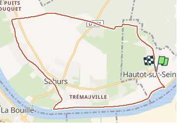
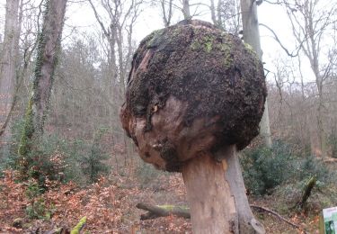
Trail Walking of 11 km to be discovered at Normandy, Seine-Maritime, Hautot-sur-Seine. This trail is proposed by MichelRando7656.

Description


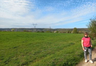
Promenade de 3 km le long de la Seine . Par un joli chemin perpendiculaire traversée vers Marbeuf. Parcours à travers Sahurs jusqu'à la ligne HT et montée vers la forêt.  Parcours de 3 km puis retour au parking

Elevation profile

Photos

Positioning

Country:
France
Region :
Normandy
Department/Province :
Seine-Maritime
Municipality :
Hautot-sur-Seine
Location:
Unknown
Start:(UTM)
353250 ; 5469524 (31U) N.

Trails nearby

Trail Walking Hautot-sur-Seine - Hautot-sur-seine  11km  - Photo
Walking
MichelRando7656

Walking

Medium
(2)
Hautot-sur-Seine, Normandy, Seine-Maritime, France
11 km | 12.2 km-effort
2h 37min
Yes
Trail Walking Petit-Couronne - Petit-couronne. Vers le puis Hébert 10 Km - Photo
Walking
MichelRando7656

Walking

Difficult
(1)
Petit-Couronne, Normandy, Seine-Maritime, France
9.7 km | 12.3 km-effort
2h 18min
Yes
Trail Walking Moulineaux - Robert-le-Diable - château - GD - V2 - Photo
Walking
philippe76

Walking

Difficult
(1)
Moulineaux, Normandy, Seine-Maritime, France
10.4 km | 13.1 km-effort
2h 58min
Yes
Trail On foot Saint-Pierre-de-Manneville - Du coté du Manoir de Villers - Photo
On foot
JMCMoreau

On foot

Easy
(1)
Saint-Pierre-de-Manneville, Normandy, Seine-Maritime, France
11 km | 12.5 km-effort
2h 45min
Yes
Trail Walking Petit-Couronne - Petit-Couronne  Rando 9km200 - Photo
Walking
MichelRando7656

Walking

Medium
(1)
Petit-Couronne, Normandy, Seine-Maritime, France
9.2 km | 11 km-effort
2h 48min
Yes
Trail Walking Saint-Pierre-de-Manneville - st pierre de mainneville - Photo
Walking
Philippe Auguste

Walking

Medium
Saint-Pierre-de-Manneville, Normandy, Seine-Maritime, France
7.6 km | 8.9 km-effort
1h 25min
Yes
Trail Walking La Bouille - La Bouille- Cote Albert Lambert-Robert le Diable - Photo
Walking
MichelRando7656

Walking

Difficult
La Bouille, Normandy, Seine-Maritime, France
14.9 km | 18.8 km-effort
4h 23min
Yes
Trail Walking Moulineaux - 20240227-Moulineaux  Cool - Photo
Walking
doudet

Walking

Easy
Moulineaux, Normandy, Seine-Maritime, France
7.8 km | 8.7 km-effort
1h 49min
Yes
Trail Walking Grand-Couronne - 20240213-Les Essarts Cool - Photo
Walking
doudet

Walking

Easy
Grand-Couronne, Normandy, Seine-Maritime, France
7.2 km | 8.5 km-effort
1h 47min
Yes


Close
My subscriptions