


Mont EREBI 583m.

DECHAMPD
User

Length
13.5 km

Max alt
553 m

Uphill gradient
621 m
Km-Effort
22 km

Min alt
192 m

Downhill gradient
622 m
Boucle
Yes
Creation date :
2019-01-14 17:35:51.497
Updated on :
2019-01-14 17:35:51.573
5h40
Difficulty : Medium

FREE GPS app for hiking
 SityTrail
IGN / Geographical institutes
SityTrail Plus
The world is yours!
About
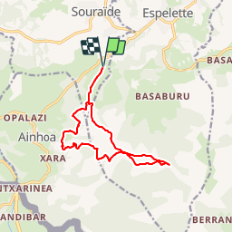
Trail Walking of 13.5 km to be discovered at New Aquitaine, Pyrénées-Atlantiques, Souraïde. This trail is proposed by DECHAMPD.
Description
depuis le col dePINADIETA, Mendiondoa, la chapelle d'Arantze et le calvaire, le col des trois croix, le refuge Gainekoborda avec contour de l'Atzulegi, la face nord de l'Erebi par le GR10.
Points of interest


Positioning
Country:
France
Region :
New Aquitaine
Department/Province :
Pyrénées-Atlantiques
Municipality :
Souraïde
Location:
Unknown
Start:(Dec)
Start:(UTM)
623854 ; 4798177 (30T) N.
Comments