Trail Walking Maing - Maing-circuit pas de boeuf, version 11km - Photo

Maing-circuit pas de boeuf, version 11km

 papiou
papiou

User

© OpenStreetMap contributors
Length
Length
11.2 km
Max alt
Max alt
89 m
Uphill gradient
Uphill gradient
100 m
Km-Effort
Km-Effort  
12.5 km
Min alt
Min alt
37 m
Downhill gradient
Downhill gradient
104 m
Boucle
Boucle
Yes
Creation date :
2021-03-28 07:25:52.108
Updated on :
2021-03-29 15:10:38.288

(0 Reviews)

Walking
Walking
2h32
Difficulty : Medium

Scan this QR Code to open this trail in the SityTrail application

FREE GPS app for hiking

Logo SityTrail SityTrail

IGN / Geographical institutes

Download SityTrail from the App Store Download SityTrail from Google Play

Logo SityTrail SityTrail World

The world is yours!

Download SityTrail from the App Store Download SityTrail from Google Play Download SityTrail on Huawei AppGallery

About

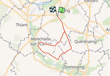
Trail Walking of 11.2 km to be discovered at Hauts-de-France, Nord, Maing. This trail is proposed by papiou.

Description

RDV parking Zola/rue 19/3. prendre CD 59 vers cimetière anglais et suivre l'appli. Attention au calvaire de Verchain en direction Querenaing ne pas prendre chemin de terre sur la gauche (nombreux obstacles de pierres anti inondation plus des arbres couchés en travers chemin.) En haut de la côte prendre 1ere à gauche pour revenir au départ.

Elevation profile

Photos

Positioning

Country:
France
Region :
Hauts-de-France
Department/Province :
Nord
Municipality :
Maing
Location:
Unknown
Start:(UTM)
534256 ; 5572451 (31U) N.

Trails nearby

Trail Mountain bike Wavrechain-sous-Denain - Direction Le Quesnoy - Denain - Photo
Mountain bike
tracegps

Mountain bike

Medium
(1)
Wavrechain-sous-Denain, Hauts-de-France, Nord, France
63 km | 70 km-effort
3h 0min
Yes
Trail Walking Vendegies-sur-Écaillon - Vendegies sur Ecaillon - Menhir 16,8 k - Photo
Walking
GUIDE
rvapeldo

Walking

Medium
Vendegies-sur-Écaillon, Hauts-de-France, Nord, France
16.8 km | 19.5 km-effort
4h 51min
Yes
Trail Walking Quérénaing - la querenaingeoise trace faite - Photo
Walking
papiou

Walking

Very easy
Quérénaing, Hauts-de-France, Nord, France
9.1 km | 10.2 km-effort
1h 33min
Yes
Trail Mountain bike Wavrechain-sous-Denain - Entre les canaux de la Scarpe et l'Escaut - Wavrechain-sous-Denain  - Photo
Mountain bike
tracegps

Mountain bike

Medium
Wavrechain-sous-Denain, Hauts-de-France, Nord, France
53 km | 57 km-effort
2h 30min
Yes
Trail Mountain bike Maing - boucle autour de Maing - Photo
Mountain bike
Obeone2264

Mountain bike

Medium
Maing, Hauts-de-France, Nord, France
16.5 km | 18.1 km-effort
2h 0min
Yes
Trail Mountain bike Wavrechain-sous-Denain - Sortie VTT Porte du Hainaut - Wavrechain sous Denain - Photo
Mountain bike
tracegps

Mountain bike

Easy
Wavrechain-sous-Denain, Hauts-de-France, Nord, France
54 km | 58 km-effort
2h 30min
Yes
Trail Walking Aulnoy-lez-Valenciennes - La vallée de la Rhonelle - Aulnoy-lez-Valenciennes - Photo
Walking
tracegps

Walking

Medium
Aulnoy-lez-Valenciennes, Hauts-de-France, Nord, France
9.9 km | 11 km-effort
2h 30min
Yes
Trail Walking Vendegies-sur-Écaillon - Circuit des Larris - Vendegies-sur-Ecaillon - Photo
Walking
tracegps

Walking

Difficult
Vendegies-sur-Écaillon, Hauts-de-France, Nord, France
16.3 km | 19 km-effort
4h 0min
Yes
Trail Walking Vendegies-sur-Écaillon - La balade du menhir   (Vendegies-sur-Ecaillon) - Photo
Walking
tracegps

Walking

Medium
Vendegies-sur-Écaillon, Hauts-de-France, Nord, France
11.3 km | 13 km-effort
2h 49min
Yes


Close
My subscriptions