Trail Walking Sentheim - Sentheim Rammersmatt Bourbach/Bas - Photo

Sentheim Rammersmatt Bourbach/Bas

 helmut68
helmut68

User

© OpenStreetMap contributors
Length
Length
20 km
Max alt
Max alt
678 m
Uphill gradient
Uphill gradient
627 m
Km-Effort
Km-Effort  
28 km
Min alt
Min alt
353 m
Downhill gradient
Downhill gradient
628 m
Boucle
Boucle
Yes
Creation date :
2021-03-28 08:30:47.028
Updated on :
2021-03-28 16:05:30.95

(0 Reviews)

Walking
Walking
4h40
Difficulty : Medium

Scan this QR Code to open this trail in the SityTrail application

FREE GPS app for hiking

Logo SityTrail SityTrail

IGN / Geographical institutes

Download SityTrail from the App Store Download SityTrail from Google Play

Logo SityTrail SityTrail World

The world is yours!

Download SityTrail from the App Store Download SityTrail from Google Play Download SityTrail on Huawei AppGallery

About

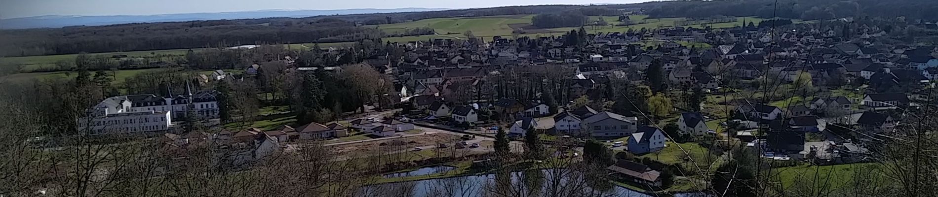
Trail Walking of 20 km to be discovered at Grand Est, Haut-Rhin, Sentheim. This trail is proposed by helmut68.

Description

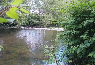
Belle boucle printanière au départ et arrivée : place de jeu de Sentheim.Apres avoir traversé la Doller ( pont des vignes ), suivez le balisage " rectangle rouge blanc rouge" direction col du Schirm . Quelques centaines de mètres avant prenez la direction Thann , balisage " triangle jaune" jusqu'à la tombe du soldat inconnu. Là reprenez le balisage " rectangle rouge blanc rouge " jusqu'à Bourbach le Bas ,puis pour finir le balisage " triangle rouge" jusqu'à Sentheim.
Point d'intérêt : sentier de découverte Rammersmatt- Bourbach le Bas .

Elevation profile

Photos

36 photos in total. Please click on a photo to see them all in the gallery.

Positioning

Country:
France
Region :
Grand Est
Department/Province :
Haut-Rhin
Municipality :
Sentheim
Location:
Unknown
Start:(UTM)
353919 ; 5290668 (32T) N.

Trails nearby

Trail Walking Masevaux-Niederbruck - Masevaux - Rossberg par le belvédère du Fuchsfelsen - Photo
Walking
Bart2015

Walking

Medium
(1)
Masevaux-Niederbruck, Grand Est, Haut-Rhin, France
19.9 km | 34 km-effort
4h 44min
Yes
Trail Walking Sentheim - Sentheim Rossberg - Photo
Walking
helmut68

Walking

Medium
(1)
Sentheim, Grand Est, Haut-Rhin, France
27 km | 40 km-effort
6h 11min
Yes
Trail Walking Lauw - 2022-07-14 Marche Lauw Refuge CAF Baerenkopf - Photo
Walking
GUIDE
holtzv

Walking

Very difficult
Lauw, Grand Est, Haut-Rhin, France
18.4 km | 31 km-effort
5h 35min
No
Trail On foot Sentheim - Sentier géologique du Wolfloch - Photo
On foot
PRO

On foot

Easy
Sentheim, Grand Est, Haut-Rhin, France
3.8 km | 4.8 km-effort
1h 5min
No
Trail On foot Sentheim - Sentheim - Bergwald - Eichwald - Guevenheim - Sentheim - Photo
On foot
patrickbeyrath

On foot

Easy
(1)
Sentheim, Grand Est, Haut-Rhin, France
13.4 km | 16.6 km-effort
Unknown
Yes
Trail Walking Sentheim - Randonnée Pentecôte 2024 - Photo
Walking
helmut68

Walking

Medium
Sentheim, Grand Est, Haut-Rhin, France
14.8 km | 18.3 km-effort
4h 0min
Yes
Trail Walking Sentheim - Knapphutte Saegenkopf Hütte - Photo
Walking
helmut68

Walking

Medium
Sentheim, Grand Est, Haut-Rhin, France
13.8 km | 17.2 km-effort
5h 11min
Yes
Trail Walking Sentheim - Montori - Photo
Walking
helmut68

Walking

Medium
Sentheim, Grand Est, Haut-Rhin, France
17.7 km | 24 km-effort
4h 47min
Yes
Trail Mountain bike Sentheim - AperoDioller - Photo
Mountain bike
helmut68

Mountain bike

Easy
Sentheim, Grand Est, Haut-Rhin, France
24 km | 27 km-effort
1h 23min
Yes


Close
My subscriptions