Trail Walking Saint-Pierre-de-Chignac - Lardimalie, chai, chateau, le puy - Photo

Lardimalie, chai, chateau, le puy

 jcc24
jcc24

User

© OpenStreetMap contributors
Length
Length
8.9 km
Max alt
Max alt
253 m
Uphill gradient
Uphill gradient
173 m
Km-Effort
Km-Effort  
11.3 km
Min alt
Min alt
162 m
Downhill gradient
Downhill gradient
186 m
Boucle
Boucle
Yes
Creation date :
2021-04-05 12:40:33.865
Updated on :
2021-04-05 17:08:18.838

(2 Reviews)

Walking
Walking
2h20
Difficulty : Easy

Scan this QR Code to open this trail in the SityTrail application

FREE GPS app for hiking

Logo SityTrail SityTrail

IGN / Geographical institutes

Download SityTrail from the App Store Download SityTrail from Google Play

Logo SityTrail SityTrail World

The world is yours!

Download SityTrail from the App Store Download SityTrail from Google Play Download SityTrail on Huawei AppGallery

About

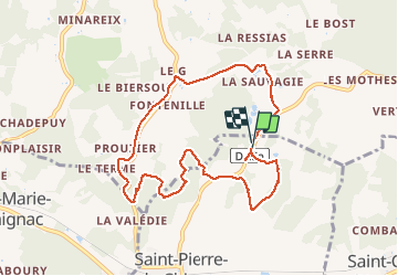
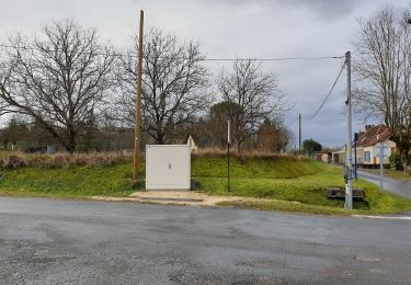
Trail Walking of 8.9 km to be discovered at New Aquitaine, Dordogne, Saint-Pierre-de-Chignac. This trail is proposed by jcc24.

Description

Départ du parking du Musée du Chai de Lardimalie. Alternance de forets, chemins et routes.

Elevation profile

Positioning

Country:
France
Region :
New Aquitaine
Department/Province :
Dordogne
Municipality :
Saint-Pierre-de-Chignac
Location:
Unknown
Start:(UTM)
332356 ; 5000451 (31T) N.

Comments

Please log in to post a review or rate the element


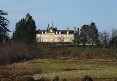
Beau site. Accessible tout le monde. Beaux bâtiments du chai.


Trails nearby

Trail On foot Saint-Pierre-de-Chignac - Boucle du Lavoir - Photo
On foot
PRO

On foot

Easy
Saint-Pierre-de-Chignac, New Aquitaine, Dordogne, France
5.3 km | 7.1 km-effort
1h 37min
Yes
Trail On foot Saint-Pierre-de-Chignac - Boucle de la Chapelle - Photo
On foot
PRO

On foot

Easy
Saint-Pierre-de-Chignac, New Aquitaine, Dordogne, France
14.7 km | 18.7 km-effort
4h 14min
No
Trail Walking Saint-Pierre-de-Chignac - boucle chai lamardie - Photo
Walking
fab0202

Walking

Easy
Saint-Pierre-de-Chignac, New Aquitaine, Dordogne, France
8.6 km | 11 km-effort
2h 45min
Yes
Trail On foot Saint-Crépin-d'Auberoche - Boucle de la Tuillère - Photo
On foot
PRO

On foot

Easy
(1)
Saint-Crépin-d'Auberoche, New Aquitaine, Dordogne, France
7.6 km | 9.5 km-effort
2h 9min
Yes
Trail On foot Saint-Crépin-d'Auberoche - Boucle de la Tuillère (Variante courte) - Photo
On foot
PRO

On foot

Easy
Saint-Crépin-d'Auberoche, New Aquitaine, Dordogne, France
5.2 km | 6.8 km-effort
1h 33min
Yes
Trail Walking Bassillac et Auberoche - Eyliac Milpas - Photo
Walking
pascalmilpas

Walking

Difficult
Bassillac et Auberoche, New Aquitaine, Dordogne, France
12.4 km | 15.8 km-effort
3h 2min
Yes
Trail Walking Bassillac et Auberoche - blis et born - Photo
Walking
bidnick

Walking

Very easy
Bassillac et Auberoche, New Aquitaine, Dordogne, France
6.2 km | 7.9 km-effort
55min
Yes
Trail Walking Saint-Pierre-de-Chignac - st pierre de chignac - Photo
Walking
ANNIEXAVE

Walking

Medium
Saint-Pierre-de-Chignac, New Aquitaine, Dordogne, France
10.9 km | 14.4 km-effort
2h 46min
Yes
Trail Walking Saint-Pierre-de-Chignac - St ¨Pierer de Chignac 11km - Photo
Walking
YV24

Walking

Easy
(1)
Saint-Pierre-de-Chignac, New Aquitaine, Dordogne, France
10.1 km | 13.5 km-effort
Unknown
Yes


Close
My subscriptions