Trail On foot Aspres-sur-Buëch - 9587028 - Photo

Les Hautes Alpes à découvrir ! GUIDE+

© OpenStreetMap contributors
Length
Length
3.4 km
Max alt
Max alt
1147 m
Uphill gradient
Uphill gradient
144 m
Km-Effort
Km-Effort  
5.3 km
Min alt
Min alt
999 m
Downhill gradient
Downhill gradient
141 m
Boucle
Boucle
Yes
Creation date :
2021-04-30 11:34:51.712
Updated on :
2021-04-30 12:57:28.384

(0 Reviews)

On foot
On foot
1h12
Difficulty : Easy

Scan this QR Code to open this trail in the SityTrail application

FREE GPS app for hiking

Logo SityTrail SityTrail

IGN / Geographical institutes

Download SityTrail from the App Store Download SityTrail from Google Play

Logo SityTrail SityTrail World

The world is yours!

Download SityTrail from the App Store Download SityTrail from Google Play Download SityTrail on Huawei AppGallery

About

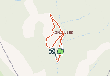
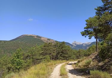
Trail On foot of 3.4 km to be discovered at Provence-Alpes-Côte d'Azur, Hautes-Alpes, Aspres-sur-Buëch. This trail is proposed by Camping Les Rives du Lac.

Description

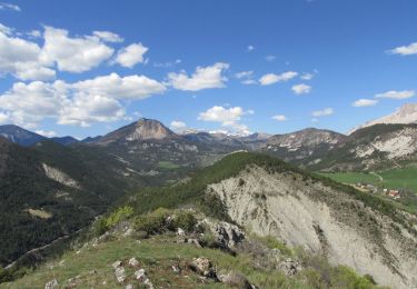
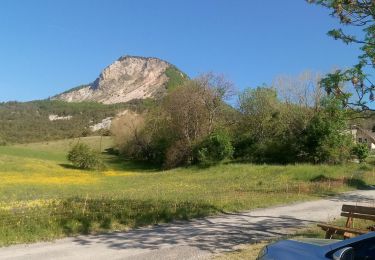
Petite boucle d'accès facile idéale en famille et en grande partie ombragée. Idéal pour un pique-nique en famille.
Départ : Parking 500 mètres avant le village d'Agnielles

Elevation profile

Photos

Positioning

Country:
France
Region :
Provence-Alpes-Côte d'Azur
Department/Province :
Hautes-Alpes
Municipality :
Aspres-sur-Buëch
Location:
Unknown
Start:(UTM)
721036 ; 4940105 (31T) N.

Trails nearby

Trail Walking La Faurie - R40   Les Marmites du Diable - Photo
Walking
GUIDE+

Walking

Medium
(6)
La Faurie, Provence-Alpes-Côte d'Azur, Hautes-Alpes, France
5.9 km | 10.4 km-effort
2h 7min
Yes
Trail Walking Veynes - R06   glaise - Photo
Walking
GUIDE+

Walking

Easy
(1)
Veynes, Provence-Alpes-Côte d'Azur, Hautes-Alpes, France
9.1 km | 14.9 km-effort
3h 4min
Yes
Trail Walking Aspres-sur-Buëch - R42   La Longeagne - Photo
Walking
GUIDE+

Walking

Very easy
(1)
Aspres-sur-Buëch, Provence-Alpes-Côte d'Azur, Hautes-Alpes, France
7.1 km | 11.2 km-effort
2h 23min
Yes
Trail Walking Veynes - Champérus-Oriol - Photo
Walking
Marco05

Walking

Difficult
Veynes, Provence-Alpes-Côte d'Azur, Hautes-Alpes, France
8 km | 16.6 km-effort
3h 45min
No
Trail Walking Veynes - col de la selle  Glaise  - Photo
Walking
Magali 83

Walking

Medium
Veynes, Provence-Alpes-Côte d'Azur, Hautes-Alpes, France
8.4 km | 14.1 km-effort
2h 42min
Yes
Trail Walking Veynes - Col de Combe noire-Veynes - Photo
Walking
Marco05

Walking

Medium
Veynes, Provence-Alpes-Côte d'Azur, Hautes-Alpes, France
9.7 km | 17.6 km-effort
4h 0min
Yes
Trail Walking Veynes - Champérus - Photo
Walking
Marco05

Walking

Medium
Veynes, Provence-Alpes-Côte d'Azur, Hautes-Alpes, France
5 km | 10.5 km-effort
2h 23min
Yes
Trail Walking Veynes - Charajaille - Photo
Walking
Marco05

Walking

Difficult
(1)
Veynes, Provence-Alpes-Côte d'Azur, Hautes-Alpes, France
8.1 km | 16.2 km-effort
3h 41min
Yes
Trail Mountain bike Aspres-sur-Buëch - Gorges de l'Agnielle - Photo
Mountain bike
jeanboulay

Mountain bike

Medium
Aspres-sur-Buëch, Provence-Alpes-Côte d'Azur, Hautes-Alpes, France
12 km | 16.7 km-effort
2h 25min
Yes


Close
My subscriptions