Trail Walking Port-Vendres - sentier du littoral Catalan - Photo

sentier du littoral Catalan

© OpenStreetMap contributors
Length
Length
18.4 km
Max alt
Max alt
112 m
Uphill gradient
Uphill gradient
436 m
Km-Effort
Km-Effort  
24 km
Min alt
Min alt
-2 m
Downhill gradient
Downhill gradient
439 m
Boucle
Boucle
No
Creation date :
2021-05-15 11:02:55.849
Updated on :
2021-05-15 21:18:31.531

(0 Reviews)

Walking
Walking
9h37
Difficulty : Medium

Scan this QR Code to open this trail in the SityTrail application

FREE GPS app for hiking

Logo SityTrail SityTrail

IGN / Geographical institutes

Download SityTrail from the App Store Download SityTrail from Google Play

Logo SityTrail SityTrail World

The world is yours!

Download SityTrail from the App Store Download SityTrail from Google Play Download SityTrail on Huawei AppGallery

About

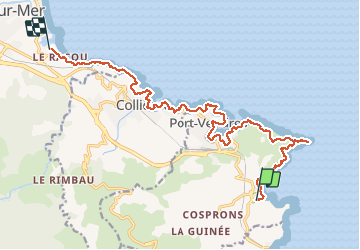
Trail Walking of 18.4 km to be discovered at Occitania, Pyrénées-Orientales, Port-Vendres. This trail is proposed by PVERTICAL.

Description

Se garer au parking du Racou. Prendre le bus à 1 euro au port d"Argelès jusqu'à l'arrêt Paulilles. les plus belles portions = de l'anse de Paulilles au Cap Bear et de Collioure au village côtier du Racou

Elevation profile

Photos

Positioning

Country:
France
Region :
Occitania
Department/Province :
Pyrénées-Orientales
Municipality :
Port-Vendres
Location:
Unknown
Start:(UTM)
510038 ; 4705381 (31T) N.

Trails nearby

Trail Walking Port-Vendres - Le sentier des douaniers (Port-Vendres) - Photo
Walking
tracegps

Walking

Medium
(5)
Port-Vendres, Occitania, Pyrénées-Orientales, France
14.5 km | 19.1 km-effort
4h 0min
Yes
Trail Walking Collioure - Collioure-le racou - Photo
Walking
jeromelacoste

Walking

Medium
(1)
Collioure, Occitania, Pyrénées-Orientales, France
7.2 km | 9.3 km-effort
2h 1min
Yes
Trail Walking Collioure - 66 COLLIOURE - les balcons de Madeloc - circuit de la tour et des fortifications  - Photo
Walking
jeff66

Walking

Difficult
(1)
Collioure, Occitania, Pyrénées-Orientales, France
9.3 km | 14.9 km-effort
2h 4min
Yes
Trail Walking Port-Vendres - PORT-VENDRES 66 - Sentier littoral jusqu'à BANYULS-SUR-MER - retour par l'arrière pays et le vignoble - Photo
Walking
jeff66

Walking

Medium
(2)
Port-Vendres, Occitania, Pyrénées-Orientales, France
10.1 km | 14 km-effort
2h 21min
Yes
Trail Walking Banyuls-sur-Mer - BANYULS- SUR-MER 66 - Sentier littoral - cap Rederis - col de la Creu - Photo
Walking
jeff66

Walking

Difficult
(2)
Banyuls-sur-Mer, Occitania, Pyrénées-Orientales, France
15.1 km | 22 km-effort
3h 45min
Yes
Trail Walking Collioure - COLLIOURE 66 - Ermitage ND de consolation - tour MADELOC - Photo
Walking
jeff66

Walking

Difficult
(4)
Collioure, Occitania, Pyrénées-Orientales, France
14.7 km | 23 km-effort
3h 41min
Yes
Trail Walking Banyuls-sur-Mer - Littoral Banyuls-Cerbere - Photo
Walking
perittel

Walking

Medium
(1)
Banyuls-sur-Mer, Occitania, Pyrénées-Orientales, France
13.6 km | 18.8 km-effort
4h 33min
Yes
Trail Walking Port-Vendres - port vendres - Photo
Walking
perittel

Walking

Very easy
(1)
Port-Vendres, Occitania, Pyrénées-Orientales, France
10.9 km | 14.8 km-effort
3h 42min
Yes
Trail Walking Banyuls-sur-Mer - Banyuls Cerbère - Littoral retour bus - 10km 4h 320m déniv. - Photo
Walking
jopost

Walking

Difficult
(1)
Banyuls-sur-Mer, Occitania, Pyrénées-Orientales, France
10 km | 14.3 km-effort
4h 12min
No


Close
My subscriptions