Trail Walking Banyuls-sur-Mer - BANYULS- SUR-MER 66 - Sentier littoral - cap Rederis - col de la Creu - Photo

BANYULS- SUR-MER 66 - Sentier littoral - cap Rederis - col de la Creu

 jeff66
jeff66

User

© OpenStreetMap contributors
Length
Length
15.1 km
Max alt
Max alt
253 m
Uphill gradient
Uphill gradient
490 m
Km-Effort
Km-Effort  
22 km
Min alt
Min alt
2 m
Downhill gradient
Downhill gradient
491 m
Boucle
Boucle
Yes
Creation date :
2015-06-13 00:00:00.0
Updated on :
2015-06-13 00:00:00.0

(2 Reviews)

Walking
Walking
3h45
Difficulty : Difficult

Scan this QR Code to open this trail in the SityTrail application

FREE GPS app for hiking

Logo SityTrail SityTrail

IGN / Geographical institutes

Download SityTrail from the App Store Download SityTrail from Google Play

Logo SityTrail SityTrail World

The world is yours!

Download SityTrail from the App Store Download SityTrail from Google Play Download SityTrail on Huawei AppGallery

About

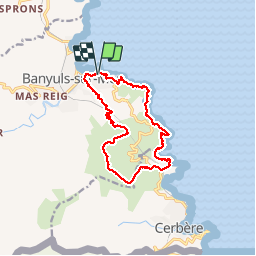
Trail Walking of 15.1 km to be discovered at Occitania, Pyrénées-Orientales, Banyuls-sur-Mer. This trail is proposed by jeff66.

Description

BANYULS- SUR-MER 66 - Thalacap - Sentier littoral - plage et cap du troc  - cap de la VELLA - plage de taillelauque - cap Rederis - Punta d'en Cames - plage de Peyrefite - col de la Creu - Col de grand Bau -

Elevation profile

Photos

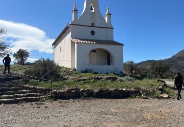
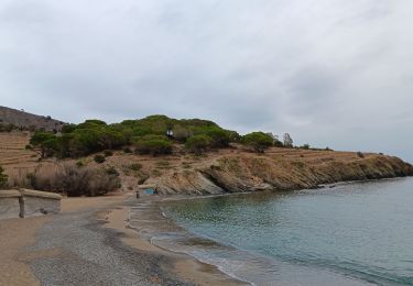
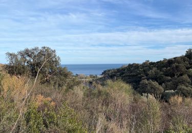
35 photos in total. Please click on a photo to see them all in the gallery.

Points of interest

Point of interest Banyuls-sur-Mer - Point 17 - Photo
jeff66
BANYULS-SUR-MER 

Positioning

Country:
France
Region :
Occitania
Department/Province :
Pyrénées-Orientales
Municipality :
Banyuls-sur-Mer
Location:
Unknown
Start:(UTM)
511268 ; 4703123 (31T) N.

Comments

Please log in to post a review or rate the element


rando trop ancienne le chemin du retour qui part de la route est totalement fermé par la végétation par ronces et piquants ,on est remonté jusqu au col en longeant la route ,pas top ,puis retour par le littoral


Trails nearby

Trail Walking Port-Vendres - Le sentier des douaniers (Port-Vendres) - Photo
Walking
tracegps

Walking

Medium
(5)
Port-Vendres, Occitania, Pyrénées-Orientales, France
14.5 km | 19.1 km-effort
4h 0min
Yes
Trail Walking Port-Vendres - PORT-VENDRES 66 - Sentier littoral jusqu'à BANYULS-SUR-MER - retour par l'arrière pays et le vignoble - Photo
Walking
jeff66

Walking

Medium
(2)
Port-Vendres, Occitania, Pyrénées-Orientales, France
10.1 km | 14 km-effort
2h 21min
Yes
Trail Walking Banyuls-sur-Mer - Littoral Banyuls-Cerbere - Photo
Walking
perittel

Walking

Medium
(1)
Banyuls-sur-Mer, Occitania, Pyrénées-Orientales, France
13.6 km | 18.8 km-effort
4h 33min
Yes
Trail Walking Port-Vendres - port vendres - Photo
Walking
perittel

Walking

Very easy
(1)
Port-Vendres, Occitania, Pyrénées-Orientales, France
10.9 km | 14.8 km-effort
3h 42min
Yes
Trail Walking Banyuls-sur-Mer - Banyuls Cerbère - Littoral retour bus - 10km 4h 320m déniv. - Photo
Walking
jopost

Walking

Difficult
(1)
Banyuls-sur-Mer, Occitania, Pyrénées-Orientales, France
10 km | 14.3 km-effort
4h 12min
No
Trail Walking Banyuls-sur-Mer - RP 66 BANYULS SUR MER - PUIG del Mas - PUIG JOAN - le 10.03.2017 - Photo
Walking
jeff66

Walking

Medium
(1)
Banyuls-sur-Mer, Occitania, Pyrénées-Orientales, France
9.7 km | 16 km-effort
2h 21min
Yes
Trail Walking Banyuls-sur-Mer - Banyuls sur Mer, chapelle notre Dame de la Salette - Photo
Walking
nandaf

Walking

Banyuls-sur-Mer, Occitania, Pyrénées-Orientales, France
6.7 km | 10.5 km-effort
2h 47min
Yes
Trail Walking Port-Vendres - anse des paulilles - cap bear / retour par les vignes - Photo
Walking
stef789

Walking

Medium
Port-Vendres, Occitania, Pyrénées-Orientales, France
5 km | 7.1 km-effort
2h 41min
Yes
Trail Walking Port-Vendres - Cosprons - Photo
Walking
nandaf

Walking

Port-Vendres, Occitania, Pyrénées-Orientales, France
5.5 km | 7.5 km-effort
1h 51min
Yes


Close
My subscriptions