La Celle St Cloud depuis Viroflay
c.chehere
User
Length
16.9 km
Max alt
184 m
Uphill gradient
286 m
Km-Effort
21 km
Min alt
114 m
Downhill gradient
285 m
Boucle
Yes
Creation date :
2021-05-18 05:52:19.611
Updated on :
2021-05-18 13:05:51.142
3h43
Difficulty : Easy
FREE GPS app for hiking
About
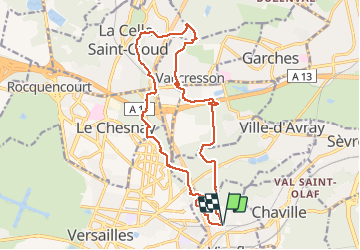
Trail Walking of 16.9 km to be discovered at Ile-de-France, Yvelines, Viroflay. This trail is proposed by c.chehere.
Description
Depuis Viroflay RD T6 ou RER L .
Belle rando en majeure partie forestière.
Pas de difficulté particulière, quelques montées pas bien méchantes
Positioning
Country:
France
Region :
Ile-de-France
Department/Province :
Yvelines
Municipality :
Viroflay
Location:
Unknown
Start:(Dec)
Start:(UTM)
438971 ; 5406199 (31U) N.
Comments
Trails nearby
Le Sentier des 7 étangs
Walking
Difficult
(5)
Chaville,
Ile-de-France,
Hauts-de-Seine,
France
23 km | 31 km-effort
5h 0min
Yes
Les 3 Forêts; Meudon, Fausses Reposes et Versailles
Walking
Difficult
(2)
Viroflay,
Ile-de-France,
Yvelines,
France
25 km | 32 km-effort
5h 19min
Yes
Sentier des deux Forêts - Meudon et Verrières
Walking
Difficult
(2)
Chaville,
Ile-de-France,
Hauts-de-Seine,
France
23 km | 29 km-effort
5h 0min
Yes
Le Tour de Satory
Walking
Difficult
(2)
Buc,
Ile-de-France,
Yvelines,
France
23 km | 28 km-effort
4h 49min
Yes
Parc de St Cloud et forêt de Fausses Reposes
Walking
Medium
(1)
Boulogne-Billancourt,
Ile-de-France,
Hauts-de-Seine,
France
18.2 km | 23 km-effort
4h 30min
No
Parc de Versailles
Other activity
Very easy
(1)
Versailles,
Ile-de-France,
Yvelines,
France
8.9 km | 9.7 km-effort
1h 49min
Yes
chaville - maison lafitte
Cycle
Medium
(1)
Chaville,
Ile-de-France,
Hauts-de-Seine,
France
44 km | 50 km-effort
3h 27min
No
grand circuit VTT
Mountain bike
Very easy
(1)
Chaville,
Ile-de-France,
Hauts-de-Seine,
France
32 km | 40 km-effort
Unknown
Yes
Etang Corot
Walking
Easy
Ville-d'Avray,
Ile-de-France,
Hauts-de-Seine,
France
3.8 km | 5 km-effort
1h 12min
Yes