


Gaschney

pascalloos
User
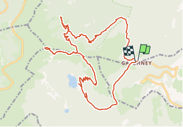

Length
14.5 km

Max alt
1355 m

Uphill gradient
712 m
Km-Effort
24 km

Min alt
934 m

Downhill gradient
707 m
Boucle
Yes
Creation date :
2021-06-12 07:04:09.13
Updated on :
2021-06-12 15:24:33.119
6h30
Difficulty : Difficult

FREE GPS app for hiking
 SityTrail
IGN / Geographical institutes
SityTrail Plus
The world is yours!
About
Trail Walking of 14.5 km to be discovered at Grand Est, Haut-Rhin, Stosswihr. This trail is proposed by pascalloos.
Description
Gaschney Frankental Schaeffer Tal
Honeck schissrothried auberge et lac et retour
Positioning
Country:
France
Region :
Grand Est
Department/Province :
Haut-Rhin
Municipality :
Stosswihr
Location:
Unknown
Start:(Dec)
Start:(UTM)
354412 ; 5321995 (32U) N.
Comments