Trail Walking Servoz - CHAMONIX (Chalets et lac de Pormenaz. - Photo

CHAMONIX (Chalets et lac de Pormenaz.

© OpenStreetMap contributors
Length
Length
7.1 km
Max alt
Max alt
2040 m
Uphill gradient
Uphill gradient
1070 m
Km-Effort
Km-Effort  
18.1 km
Min alt
Min alt
975 m
Downhill gradient
Downhill gradient
97 m
Boucle
Boucle
No
Creation date :
2017-06-28 00:00:00.0
Updated on :
2017-06-28 00:00:00.0

(0 Reviews)

Walking
Walking
8h01
Difficulty : Medium

Scan this QR Code to open this trail in the SityTrail application

FREE GPS app for hiking

Logo SityTrail SityTrail

IGN / Geographical institutes

Download SityTrail from the App Store Download SityTrail from Google Play

Logo SityTrail SityTrail World

The world is yours!

Download SityTrail from the App Store Download SityTrail from Google Play Download SityTrail on Huawei AppGallery

About

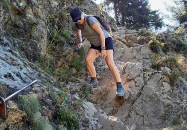
Trail Walking of 7.1 km to be discovered at Auvergne-Rhône-Alpes, Upper Savoy, Servoz. This trail is proposed by GerardBouche.

Description

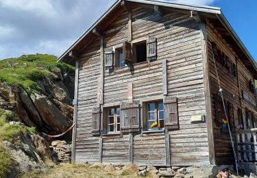
Au départ de SERVOZ depuis le parking du lieu dit "Le Mont)un sentier ombragé puis à découvert vous emmène vers les chalets de Pormenaz et le Lac de Pormenaz... une journée de marche A/R.

Elevation profile

Positioning

Country:
France
Region :
Auvergne-Rhône-Alpes
Department/Province :
Upper Savoy
Municipality :
Servoz
Location:
Unknown
Start:(UTM)
327142 ; 5089834 (32T) N.

Trails nearby

Trail Walking Passy - Tour des Ayères - Passy Plaine-Joux - Photo
Walking
tracegps

Walking

Medium
(6)
Passy, Auvergne-Rhône-Alpes, Upper Savoy, France
9 km | 14.3 km-effort
2h 30min
Yes
Trail Walking Passy - Plaine Joux Barmus Ayères Lac Vert  - Photo
Walking
GUIDE
Kargil

Walking

Very easy
(1)
Passy, Auvergne-Rhône-Alpes, Upper Savoy, France
7.6 km | 12.2 km-effort
2h 18min
Yes
Trail Walking Chamonix-Mont-Blanc - Glacier des Bossons Les Houches Chamonix - Photo
Walking
tracegps

Walking

Difficult
(2)
Chamonix-Mont-Blanc, Auvergne-Rhône-Alpes, Upper Savoy, France
13.1 km | 28 km-effort
5h 0min
Yes
Trail Walking Passy - Plaine Joux-Passage du derochoir-Col de Portette-Platé - Photo
Walking
GUIDE
Kargil

Walking

Difficult
Passy, Auvergne-Rhône-Alpes, Upper Savoy, France
14.4 km | 30 km-effort
6h 42min
Yes
Trail Running Passy - grimpe de chedde ayeres - Photo
Running
winbat11

Running

Very easy
(1)
Passy, Auvergne-Rhône-Alpes, Upper Savoy, France
15 km | 28 km-effort
2h 46min
No
Trail Walking Les Houches - Chalets de Charlousse - Photo
Walking
YannPro81

Walking

Easy
(2)
Les Houches, Auvergne-Rhône-Alpes, Upper Savoy, France
9.2 km | 14.1 km-effort
2h 28min
Yes
Trail Walking Les Houches - boucle aiguillette des houches ,refuge bel-lachat - Photo
Walking
carton-fils@orange.fr

Walking

Very difficult
Les Houches, Auvergne-Rhône-Alpes, Upper Savoy, France
10.4 km | 24 km-effort
2h 49min
Yes
Trail Walking Les Houches - échec refuge de bellachat - Photo
Walking
carton-fils@orange.fr

Walking

Medium
Les Houches, Auvergne-Rhône-Alpes, Upper Savoy, France
3.9 km | 8.1 km-effort
2h 38min
Yes
Trail Walking Les Houches - Parc Animalier Merlet - Chalets de Chailloux - Aiguillettes des Houches - Photo
Walking
LtZIP

Walking

Difficult
Les Houches, Auvergne-Rhône-Alpes, Upper Savoy, France
11 km | 23 km-effort
5h 17min
Yes


Close
My subscriptions