![](/images/other/stat-length.png)
![Trail Walking Laruns - Cascade de Seris Laruns 64 - Photo](https://media.geolcdn.com/t/1900/400/ext.pjpeg?maxdim=2&url=https%3A%2F%2Fstatic1.geolcdn.com%2Fsiteimages%2Fupload%2Ffiles%2F1553511878bg_sport_marche.png)
Cascade de Seris Laruns 64
rogerpoirier
User
![Length](/images/other/stat-length.png)
Length
3.2 km
![Max alt](https://static1.geolcdn.com/siteimages/upload/files/1508320355ic_sort_altitude_max_24dp.png)
Max alt
857 m
![Uphill gradient](https://static1.geolcdn.com/siteimages/upload/files/1508320355ic_sort_den_pos_24dp.png)
Uphill gradient
271 m
![Km-Effort](/images/other/stat-length.png)
Km-Effort
6.8 km
![Min alt](https://static1.geolcdn.com/siteimages/upload/files/1508320355ic_sort_altitude_min_24dp.png)
Min alt
552 m
![Downhill gradient](https://static1.geolcdn.com/siteimages/upload/files/1508320355ic_sort_den_neg_24dp.png)
Downhill gradient
271 m
![Boucle](https://static1.geolcdn.com/siteimages/upload/files/16400158638029165_repeat_loop_refresh_sync_direction_icon.png)
Boucle
Yes
Creation date :
2021-07-24 15:57:51.465
Updated on :
2021-07-26 16:30:16.853
![Walking](https://static1.geolcdn.com/sitytour/trail-icons/101.png)
1h32
Difficulty : Medium
![Scan this QR Code to open this trail in the SityTrail application](https://capi.geolives.com/qq0zvz2zws4bq2lad0pu/sitytour/trails/2872483/qr.png?size=200)
FREE GPS app for hiking
About
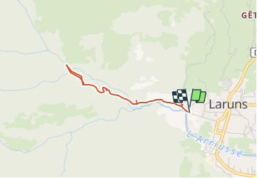
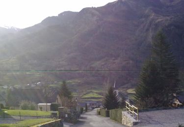
Trail Walking of 3.2 km to be discovered at New Aquitaine, Pyrénées-Atlantiques, Laruns. This trail is proposed by rogerpoirier.
Description
Chemin ombragé, montée soutenue, mais souvent des pavés humides, attention à la descente. Mais la beauté de cette cascade de 35 mètres. Ne pas oublier, après la cascade d'accéder au promontoire, à quelques minutes, d'où l'on a une vue totale de la cascade et de sa vasque.
Positioning
Country:
France
Region :
New Aquitaine
Department/Province :
Pyrénées-Atlantiques
Municipality :
Laruns
Location:
Unknown
Start:(Dec)
Start:(UTM)
709411 ; 4762633 (30T) N.
Comments
Trails nearby
![Trail Walking Béost - Behost - Photo](https://media.geolcdn.com/t/375/260/ext.jpg?maxdim=2&url=https%3A%2F%2Fservices.sitytrail.com%2FGeolivesWS%2FDownloadMedia.ashx%3FTrailID%3D970820%26Media%3Dfix__20180521114303.jpg)
![Walking Walking](https://static1.geolcdn.com/sitytour/trail-icons/101.png)
Behost
Walking
Easy
(1)
Béost,
New Aquitaine,
Pyrénées-Atlantiques,
France
![](/images/other/stat-length.png)
6 km | 9.9 km-effort
2h 59min
![](https://static1.geolcdn.com/siteimages/upload/files/16400158638029165_repeat_loop_refresh_sync_direction_icon.png)
Yes
![Trail Walking Bielle - Pics de Cambeilh et petit Gerbe - Photo](https://media.geolcdn.com/t/375/260/ext.jpg?maxdim=2&url=https%3A%2F%2Fservices.sitytrail.com%2FGeolivesWS%2FDownloadMedia.ashx%3FTrailID%3D521181%26Media%3Dfix__20160202151847.jpg)
![Walking Walking](https://static1.geolcdn.com/sitytour/trail-icons/101.png)
Pics de Cambeilh et petit Gerbe
Walking
Easy
(1)
Bielle,
New Aquitaine,
Pyrénées-Atlantiques,
France
![](/images/other/stat-length.png)
13.7 km | 27 km-effort
5h 24min
![](https://static1.geolcdn.com/siteimages/upload/files/16400158638029165_repeat_loop_refresh_sync_direction_icon.png)
Yes
![Trail Walking Laruns - LARUNS le tour du valentin G3](https://media.geolcdn.com/t/375/260/ext.jpg?maxdim=2&url=https%3A%2F%2Fmedia.geolcdn.com%2Ff%2Fab9ea3e2-49dc-47a2-9b64-4673b336581b.jpg)
![Walking Walking](https://static1.geolcdn.com/sitytour/trail-icons/101.png)
LARUNS le tour du valentin G3 "3717878"
Walking
Difficult
Laruns,
New Aquitaine,
Pyrénées-Atlantiques,
France
![](/images/other/stat-length.png)
9.1 km | 14.7 km-effort
3h 20min
![](https://static1.geolcdn.com/siteimages/upload/files/16400158638029165_repeat_loop_refresh_sync_direction_icon.png)
Yes
![Trail On foot Eaux-Bonnes - La promenade horizontale - Photo](https://media.geolcdn.com/t/375/260/ext.jpg?maxdim=2&url=https%3A%2F%2Fmedia.geolcdn.com%2Ff%2F65015aca-92a7-4f38-9cb0-181d1c21acb1.jpeg)
![On foot On foot](https://static1.geolcdn.com/sitytour/trail-icons/100.png)
La promenade horizontale
On foot
Easy
Eaux-Bonnes,
New Aquitaine,
Pyrénées-Atlantiques,
France
![](/images/other/stat-length.png)
3.5 km | 5.3 km-effort
1h 12min
![](https://static1.geolcdn.com/siteimages/upload/files/16400158638029165_repeat_loop_refresh_sync_direction_icon.png)
Yes
![Trail On foot Eaux-Bonnes - Les thermes - Photo](https://media.geolcdn.com/t/375/260/ext.jpg?maxdim=2&url=https%3A%2F%2Fmedia.geolcdn.com%2Ff%2F65015aca-92a7-4f38-9cb0-181d1c21acb1.jpeg)
![On foot On foot](https://static1.geolcdn.com/sitytour/trail-icons/100.png)
Les thermes
On foot
Easy
Eaux-Bonnes,
New Aquitaine,
Pyrénées-Atlantiques,
France
![](/images/other/stat-length.png)
3.6 km | 5.9 km-effort
1h 20min
![](https://static1.geolcdn.com/siteimages/upload/files/16400158638029165_repeat_loop_refresh_sync_direction_icon.png)
Yes
![Trail On foot Laruns - L'eau - Photo](https://media.geolcdn.com/t/375/260/ext.jpg?maxdim=2&url=https%3A%2F%2Fmedia.geolcdn.com%2Ff%2F63c634b8-343f-473c-b626-d31545ed6396.jpeg)
![On foot On foot](https://static1.geolcdn.com/sitytour/trail-icons/100.png)
L'eau
On foot
Easy
Laruns,
New Aquitaine,
Pyrénées-Atlantiques,
France
![](/images/other/stat-length.png)
4.8 km | 5.9 km-effort
1h 20min
![](https://static1.geolcdn.com/siteimages/upload/files/16400158638029165_repeat_loop_refresh_sync_direction_icon.png)
Yes
![Trail On foot Eaux-Bonnes - La montagne verte - Photo](https://media.geolcdn.com/t/375/260/ext.jpg?maxdim=2&url=https%3A%2F%2Fmedia.geolcdn.com%2Ff%2F065373cf-29fb-4e68-99c0-c8817fd47c70.jpeg)
![On foot On foot](https://static1.geolcdn.com/sitytour/trail-icons/100.png)
La montagne verte
On foot
Easy
Eaux-Bonnes,
New Aquitaine,
Pyrénées-Atlantiques,
France
![](/images/other/stat-length.png)
10.4 km | 17.8 km-effort
4h 2min
![](https://static1.geolcdn.com/siteimages/upload/files/16400158638029165_repeat_loop_refresh_sync_direction_icon.png)
Yes
![Trail On foot Louvie-Soubiron - Les carrières - Photo](https://media.geolcdn.com/t/375/260/ext.jpg?maxdim=2&url=https%3A%2F%2Fmedia.geolcdn.com%2Ff%2F42bd8070-fba7-4e59-8765-7818609a2f81.jpeg)
![On foot On foot](https://static1.geolcdn.com/sitytour/trail-icons/100.png)
Les carrières
On foot
Easy
Louvie-Soubiron,
New Aquitaine,
Pyrénées-Atlantiques,
France
![](/images/other/stat-length.png)
3.4 km | 7 km-effort
1h 35min
![](https://static1.geolcdn.com/siteimages/upload/files/16400158638029165_repeat_loop_refresh_sync_direction_icon.png)
Yes
![Trail On foot Béost - La promenade des trois villages - Photo](https://media.geolcdn.com/t/375/260/ext.jpg?maxdim=2&url=https%3A%2F%2Fmedia.geolcdn.com%2Ff%2Fb95395a3-1e10-4876-a4b8-b1081a1283f7.jpeg)
![On foot On foot](https://static1.geolcdn.com/sitytour/trail-icons/100.png)
La promenade des trois villages
On foot
Easy
Béost,
New Aquitaine,
Pyrénées-Atlantiques,
France
![](/images/other/stat-length.png)
5.1 km | 8.6 km-effort
1h 56min
![](https://static1.geolcdn.com/siteimages/upload/files/16400158638029165_repeat_loop_refresh_sync_direction_icon.png)
Yes