Trail On foot Bailleul - boucle de 13km à OUTTERSTEENE - Photo

boucle de 13km à OUTTERSTEENE

© OpenStreetMap contributors
Length
Length
13.1 km
Max alt
Max alt
38 m
Uphill gradient
Uphill gradient
63 m
Km-Effort
Km-Effort  
13.9 km
Min alt
Min alt
15 m
Downhill gradient
Downhill gradient
61 m
Boucle
Boucle
Yes
Creation date :
2021-08-14 11:55:25.735
Updated on :
2021-08-14 11:57:22.049

(0 Reviews)

On foot
On foot
3h09
Difficulty : Easy

Scan this QR Code to open this trail in the SityTrail application

FREE GPS app for hiking

Logo SityTrail SityTrail

IGN / Geographical institutes

Download SityTrail from the App Store Download SityTrail from Google Play

Logo SityTrail SityTrail World

The world is yours!

Download SityTrail from the App Store Download SityTrail from Google Play Download SityTrail on Huawei AppGallery

About

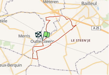
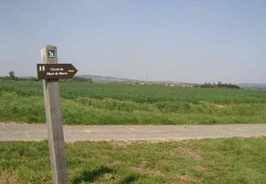
Trail On foot of 13.1 km to be discovered at Hauts-de-France, Nord, Bailleul. This trail is proposed by eaea7charles.

Description

BOUCLE FACILE SUR DES CHEMINS GOUDRONNES

Elevation profile

Positioning

Country:
France
Region :
Hauts-de-France
Department/Province :
Nord
Municipality :
Bailleul
Location:
Unknown
Start:(UTM)
477551 ; 5617854 (31U) N.

Trails nearby

Trail Motor Bailleul - 104 - Photo
Motor
abalcerek

Motor

Very easy
(3)
Bailleul, Hauts-de-France, Nord, France
127 km | 140 km-effort
3h 49min
No
Trail Running Bailleul - bailleul - Photo
Running
jamboxland

Running

Easy
Bailleul, Hauts-de-France, Nord, France
14.4 km | 16.6 km-effort
1h 20min
Yes
Trail Walking Flêtre - Sentier du Bois Greffier - Flêtre - Photo
Walking
tracegps

Walking

Medium
Flêtre, Hauts-de-France, Nord, France
11.5 km | 13.2 km-effort
2h 55min
Yes
Trail Walking Méteren - Sentier des 4 fils Aymon - Méteren - Photo
Walking
tracegps

Walking

Medium
Méteren, Hauts-de-France, Nord, France
10.9 km | 13.1 km-effort
2h 45min
Yes
Trail Walking Bailleul - Sentier du Ravensberg - Bailleul - Photo
Walking
tracegps

Walking

Difficult
Bailleul, Hauts-de-France, Nord, France
14.4 km | 16.8 km-effort
3h 40min
Yes
Trail Mountain bike Strazeele - Circuit de Strazeele - Photo
Mountain bike
tracegps

Mountain bike

Easy
(1)
Strazeele, Hauts-de-France, Nord, France
7.5 km | 8.2 km-effort
40min
Yes
Trail Walking Strazeele - Circuit de Strazeele - Photo
Walking
tracegps

Walking

Easy
Strazeele, Hauts-de-France, Nord, France
7.5 km | 8.2 km-effort
1h 49min
Yes
Trail Mountain bike Merris - Circuit du Mont de Merris - Photo
Mountain bike
tracegps

Mountain bike

Easy
Merris, Hauts-de-France, Nord, France
11.1 km | 12 km-effort
55min
Yes
Trail Walking Merris - Circuit du Mont de Merris - Photo
Walking
tracegps

Walking

Medium
Merris, Hauts-de-France, Nord, France
11.1 km | 12 km-effort
2h 45min
Yes


Close
My subscriptions