Trail Walking Violay - Départ de Violay - Photo
© OpenStreetMap contributors
Length
Length
16.2 km
Max alt
Max alt
874 m
Uphill gradient
Uphill gradient
498 m
Km-Effort
Km-Effort  
23 km
Min alt
Min alt
646 m
Downhill gradient
Downhill gradient
477 m
Boucle
Boucle
No
Creation date :
2021-08-19 11:59:50.843
Updated on :
2021-08-22 12:54:11.693

(0 Reviews)

Walking
Walking
4h50
Difficulty : Medium

Scan this QR Code to open this trail in the SityTrail application

FREE GPS app for hiking

Logo SityTrail SityTrail

IGN / Geographical institutes

Download SityTrail from the App Store Download SityTrail from Google Play

Logo SityTrail SityTrail World

The world is yours!

Download SityTrail from the App Store Download SityTrail from Google Play Download SityTrail on Huawei AppGallery

About

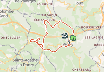
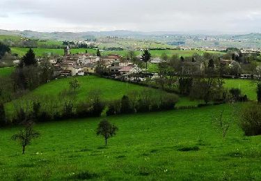
Trail Walking of 16.2 km to be discovered at Auvergne-Rhône-Alpes, Loire, Violay. This trail is proposed by mimi69670.

Description

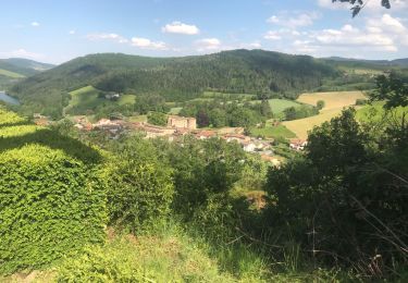
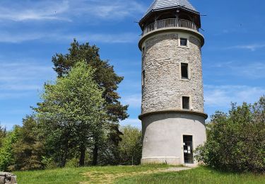
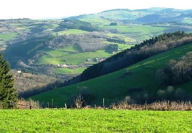
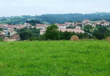
Départ de la mairie de Violay, une perte des sauvages, rando autour des monts du Forez, barrage du Gantet, Croix Armide, Chapelle St Roch, vestige d'un coquillage (chemin de Compostelle) sur la façade du mur de l'hepad Les Jacinthes à Violay(les pèlerins de Compostelle à l''époque se reposait à cet endroit), retour sur Violay en finissant par un bon dénivelé.

Elevation profile

Photos

Positioning

Country:
France
Region :
Auvergne-Rhône-Alpes
Department/Province :
Loire
Municipality :
Violay
Location:
Unknown
Start:(UTM)
605438 ; 5078550 (31T) N.

Trails nearby

Trail Walking Sainte-Agathe-en-Donzy - Sentier botanique de la Belette - Photo
Walking
alain0902

Walking

Easy
(2)
Sainte-Agathe-en-Donzy, Auvergne-Rhône-Alpes, Loire, France
6.3 km | 8.7 km-effort
2h 20min
Yes
Trail Walking Violay - Randonnée au dessus de Violay  - Photo
Walking
dudu42

Walking

Difficult
Violay, Auvergne-Rhône-Alpes, Loire, France
17.3 km | 26 km-effort
5h 26min
Yes
Trail Walking Montchal - randonnée de Montchal - Photo
Walking
dudu42

Walking

Medium
Montchal, Auvergne-Rhône-Alpes, Loire, France
14.1 km | 19.5 km-effort
3h 56min
Yes
Trail Walking Violay - La Tour de Matagrin avec un départ à Violay - Photo
Walking
mimi69670

Walking

Medium
Violay, Auvergne-Rhône-Alpes, Loire, France
14.6 km | 21 km-effort
4h 28min
Yes
Trail Walking Joux - Joux (17 km - D. 625 m) - Photo
Walking
Thomasdanielle

Walking

Very difficult
Joux, Auvergne-Rhône-Alpes, Rhône, France
16.5 km | 25 km-effort
5h 38min
Yes
Trail Walking Violay - Violay - La Tour Matagrin - Photo
Walking
Sigmut

Walking

Medium
Violay, Auvergne-Rhône-Alpes, Loire, France
5.8 km | 8.3 km-effort
1h 56min
Yes
Trail Mountain bike Violay - Rando VTT de l'Ecole Arc en Ciel - Violay - Photo
Mountain bike
tracegps

Mountain bike

Very difficult
Violay, Auvergne-Rhône-Alpes, Loire, France
21 km | 30 km-effort
2h 30min
Yes
Trail Mountain bike Montchal - 24ème Rando VTT de la Tour Matagrin - Montchal (2012) - Photo
Mountain bike
tracegps

Mountain bike

Very difficult
Montchal, Auvergne-Rhône-Alpes, Loire, France
72 km | 98 km-effort
5h 15min
Yes
Trail Mountain bike Sainte-Agathe-en-Donzy - A4 - VTT Montagnes du Matin - Sainte Agathe en Donzy - Photo
Mountain bike
tracegps

Mountain bike

Difficult
Sainte-Agathe-en-Donzy, Auvergne-Rhône-Alpes, Loire, France
17.9 km | 24 km-effort
2h 0min
Yes


Close
My subscriptions