


Gaschney Hohneck kerbholz Gaschney

sit68000
User
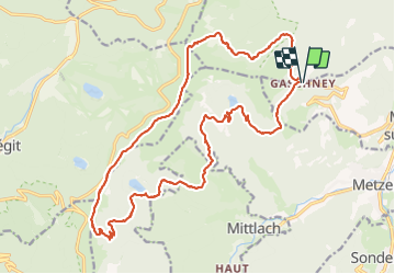

Length
23 km

Max alt
1304 m

Uphill gradient
999 m
Km-Effort
36 km

Min alt
918 m

Downhill gradient
996 m
Boucle
Yes
Creation date :
2021-09-17 07:01:32.103
Updated on :
2021-09-17 18:24:59.799
9h31
Difficulty : Very difficult

FREE GPS app for hiking
 SityTrail
IGN / Geographical institutes
SityTrail Plus
The world is yours!
About
Trail Walking of 23 km to be discovered at Grand Est, Haut-Rhin, Stosswihr. This trail is proposed by sit68000.
Description
Gaschney Hohneck Rainkopf Leibelthal Altenweiher Kerbholz Schliessrothried Gaschney
Positioning
Country:
France
Region :
Grand Est
Department/Province :
Haut-Rhin
Municipality :
Stosswihr
Location:
Unknown
Start:(Dec)
Start:(UTM)
354396 ; 5321962 (32U) N.
Comments