


Vingrau

Ada11
User GUIDE
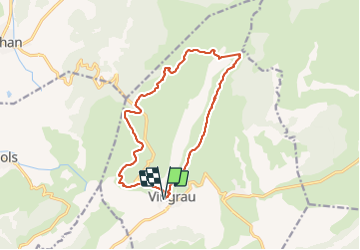

Length
15.5 km

Max alt
551 m

Uphill gradient
485 m
Km-Effort
22 km

Min alt
143 m

Downhill gradient
486 m
Boucle
Yes
Creation date :
2021-09-12 07:12:40.239
Updated on :
2021-09-19 07:34:36.999
4h20
Difficulty : Medium

FREE GPS app for hiking
 SityTrail
IGN / Geographical institutes
SityTrail Plus
The world is yours!
About
Trail Walking of 15.5 km to be discovered at Occitania, Pyrénées-Orientales, Vingrau. This trail is proposed by Ada11.
Description
Belle rando, surtout la moitié sur le relief. À ne pas faire en cas de chaleur ou de pluie.
Photos


Positioning
Country:
France
Region :
Occitania
Department/Province :
Pyrénées-Orientales
Municipality :
Vingrau
Location:
Unknown
Start:(Dec)
Start:(UTM)
481742 ; 4743984 (31T) N.
Comments