Trail Walking Masevaux-Niederbruck - Les Dames nobles de Masevaux  - Photo

Les Dames nobles de Masevaux

 helmut68
helmut68

User

© OpenStreetMap contributors
Length
Length
12.3 km
Max alt
Max alt
765 m
Uphill gradient
Uphill gradient
397 m
Km-Effort
Km-Effort  
17.6 km
Min alt
Min alt
404 m
Downhill gradient
Downhill gradient
400 m
Boucle
Boucle
Yes
Creation date :
2021-10-01 08:49:32.001
Updated on :
2021-10-01 19:42:33.922

(0 Reviews)

Walking
Walking
3h00
Difficulty : Medium

Scan this QR Code to open this trail in the SityTrail application

FREE GPS app for hiking

Logo SityTrail SityTrail

IGN / Geographical institutes

Download SityTrail from the App Store Download SityTrail from Google Play

Logo SityTrail SityTrail World

The world is yours!

Download SityTrail from the App Store Download SityTrail from Google Play Download SityTrail on Huawei AppGallery

About

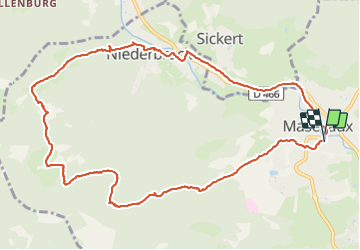
Trail Walking of 12.3 km to be discovered at Grand Est, Haut-Rhin, Masevaux-Niederbruck. This trail is proposed by helmut68.

Description

Départ de l'ancienne abbaye ( place du marché), en suivant les balisages " rectangle jaune et rouge " vers le sud . La route s'élève vers Stoecken où vous passerez devant une petite chapelle. Quelques centaines de mètres plus haut , abandonner sur votre gauche les "rectangles jaune et rouge" pour poursuivre sur le " rectangle bleu " GR 531 jusqu'à la ferme auberge du Bruckenwald.
Après un arrêt salvateur ou non , prendre le balisage " anneau jaune " jusqu'à Niederbruck.
Traverser le village et poursuivez sur  la piste cyclable en direction de Masevaux jusqu'à l'abbaye ...
Alors à vos chaussures...

Elevation profile

Photos

30 photos in total. Please click on a photo to see them all in the gallery.

Positioning

Country:
France
Region :
Grand Est
Department/Province :
Haut-Rhin
Municipality :
Masevaux-Niederbruck
Location:
Unknown
Start:(UTM)
349918 ; 5293034 (32T) N.

Trails nearby

Trail Walking Masevaux-Niederbruck - Masevaux - Rossberg par le belvédère du Fuchsfelsen - Photo
Walking
Bart2015

Walking

Medium
(1)
Masevaux-Niederbruck, Grand Est, Haut-Rhin, France
19.9 km | 34 km-effort
4h 44min
Yes
Trail Walking Sentheim - Sentheim Rossberg - Photo
Walking
helmut68

Walking

Medium
(1)
Sentheim, Grand Est, Haut-Rhin, France
27 km | 40 km-effort
6h 11min
Yes
Trail Walking Bourbach-le-Haut - 2024-01-12_14h17m14_239006910 - Photo
Walking
GUIDE
mumu.larandonneuse

Walking

Difficult
Bourbach-le-Haut, Grand Est, Haut-Rhin, France
11.4 km | 18.5 km-effort
4h 12min
Yes
Trail Walking Lauw - 2022-07-14 Marche Lauw Refuge CAF Baerenkopf - Photo
Walking
GUIDE
holtzv

Walking

Very difficult
Lauw, Grand Est, Haut-Rhin, France
18.4 km | 31 km-effort
5h 35min
No
Trail On foot Sentheim - Sentier géologique du Wolfloch - Photo
On foot
PRO

On foot

Easy
Sentheim, Grand Est, Haut-Rhin, France
3.8 km | 4.8 km-effort
1h 5min
No
Trail On foot Sentheim - Sentheim - Bergwald - Eichwald - Guevenheim - Sentheim - Photo
On foot
patrickbeyrath

On foot

Easy
(1)
Sentheim, Grand Est, Haut-Rhin, France
13.4 km | 16.6 km-effort
Unknown
Yes
Trail Walking Bitschwiller-lès-Thann - 68 Col du Hundsrück  - FA Gsang - retour ThannerHubel - Photo
Walking

Walking

Medium
(1)
Bitschwiller-lès-Thann, Grand Est, Haut-Rhin, France
11.2 km | 18.4 km-effort
3h 48min
Yes
Trail Walking Masevaux-Niederbruck - Rando CLAS du 25/04/2024 - Photo
Walking
boubou68

Walking

Very difficult
Masevaux-Niederbruck, Grand Est, Haut-Rhin, France
17 km | 28 km-effort
4h 24min
Yes
Trail Walking Kirchberg - Rando du 11/04/2024  ..Marcheurs - Photo
Walking
boubou68

Walking

Very difficult
Kirchberg, Grand Est, Haut-Rhin, France
23 km | 37 km-effort
5h 37min
Yes


Close
My subscriptions